7 things you probably didn’t know about maps | CNN

CNN values your feedback

1. How relevant is this ad to you?
2. Did you encounter any technical issues?
Thank You!
Your effort and contribution in providing this feedback is much appreciated.
Close
Ad Feedback
Destinations
Food & Drink
News
Stay
Video
Destinations Food & Drink News Stay Video
Watch Listen Live TV
My Account
  • Settings
  • Newsletters
  • Topics you follow
  • Sign out
Your CNN account Sign in to your CNN account

My Account
  • Settings
  • Newsletters
  • Topics you follow
  • Sign out
Your CNN account Sign in to your CNN account

Live TV Listen Watch
Edition
US
International
Arabic
Español
Edition
  • US
  • International
  • Arabic
  • Español

Destinations
Food & Drink
News
Stay
Video

Follow CNN Travel
Download the CNN App

  • World
    • Africa
    • Americas
    • Asia
    • Australia
    • China
    • Europe
    • India
    • Middle East
    • United Kingdom
  • US Politics
    • Elections 2026
    • Trump
    • Facts First
    • CNN Polls
    • Redistricting Tracker
    • Epstein Files
  • Business
    • Tech
    • Media
    • Calculators
    • Videos
  • Markets
    • Pre-markets
    • After-Hours
    • Fear & Greed
    • Investing
  • Health
    • Life, But Better
    • Fitness
    • Food
    • Sleep
    • Mindfulness
    • Relationships
  • Entertainment
    • Movies
    • Television
    • Celebrity
  • Tech
    • Innovate
  • Style
    • Arts
    • Design
    • Fashion
    • Architecture
    • Luxury
    • Beauty
    • Video
  • Travel
    • Destinations
    • Food & Drink
    • Stay
    • News
    • Videos
  • Sports
    • Football
    • Tennis
    • Golf
    • Motorsport
    • US Sports
    • Olympics
  • Science
    • Space
    • Life
    • Unearthed
  • Climate
    • Solutions
    • Weather
  • Weather
    • Video
    • Climate
  • Ukraine-Russia War
  • Israel-Hamas War
  • Features
    • As Equals
    • Call to Earth
    • Freedom Project
    • Impact Your World
    • Inside Africa
    • CNN Heroes
  • Watch
    • Live TV
    • Featured
    • CNN Fast
    • Shows A-Z
    • CNN 10
    • CNN TV Schedule
  • Listen
    • All There Is with Anderson Cooper
    • Chasing Life with Dr. Sanjay Gupta
    • The Assignment with Audie Cornish
    • Terms of Service with Clare Duffy
    • CNN 5 Things
    • All CNN Podcasts
  • Games
    • Daily Crossword
    • Jumble Crossword
    • Photo Shuffle
    • Sudoblock
    • Sudoku
    • 5 Things Quiz
  • About CNN
    • Photos
    • Investigations
    • CNN Profiles
    • CNN Leadership
    • CNN Newsletters
    • Work for CNN

Download the CNN App
Travel

7 things you probably didn’t know about maps

Updated 4:23 PM EST, Sun February 2, 2014
Link Copied!
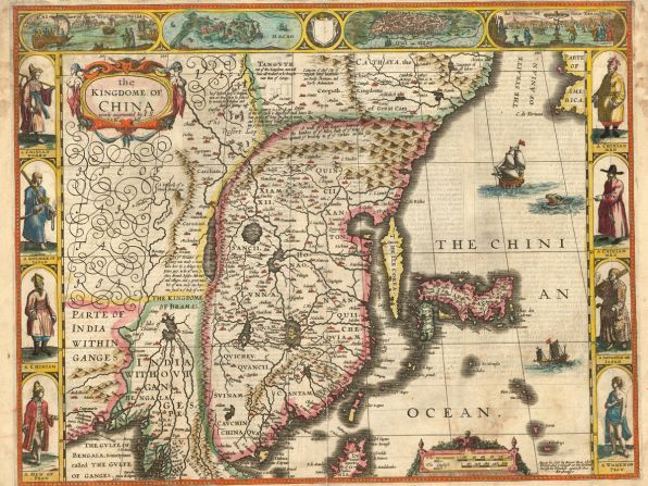
London-based map dealer Daniel Crouch shares a few unusual or rare maps from a recent exhibition in Hong Kong. According to Crouch, maps of BRIC nations (Brazil, Russia, India and China) are rising in popularity among map collectors. This 17th-century map of China is a double-page hand-colored engraved map published in 1665 by John Speed.
'The Kingdome of China,' 1665 —
London-based map dealer Daniel Crouch shares a few unusual or rare maps from a recent exhibition in Hong Kong. According to Crouch, maps of BRIC nations (Brazil, Russia, India and China) are rising in popularity among map collectors. This 17th-century map of China is a double-page hand-colored engraved map published in 1665 by John Speed.
courtesy daniel crouch
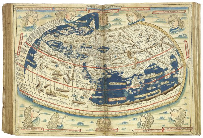
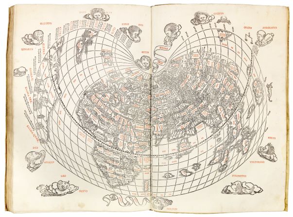
This "very fine" Venetian edition of Ptolemy's Geographica is the first atlas wholly printed in color, and the map (pictured) in the atlas is the first printed map to indicate Japan, and the second Ptolemaic world map to show America.
Ptolomy's 'Geographica,' 1511 —
This "very fine" Venetian edition of Ptolemy's Geographica is the first atlas wholly printed in color, and the map (pictured) in the atlas is the first printed map to indicate Japan, and the second Ptolemaic world map to show America.
courtesy Daniel Crouch
The world map within the 1482 edition of the Ptolemaic corpus is the first printed cartographical representation of Greenland, Iceland and the North Atlantic and the earliest datable printed map to bear a signature -- that of Johannes of Arnsheim.
Ptolemy's 'Cosmographica,' 1482 —
The world map within the 1482 edition of the Ptolemaic corpus is the first printed cartographical representation of Greenland, Iceland and the North Atlantic and the earliest datable printed map to bear a signature -- that of Johannes of Arnsheim.
courtesy daniel crouch
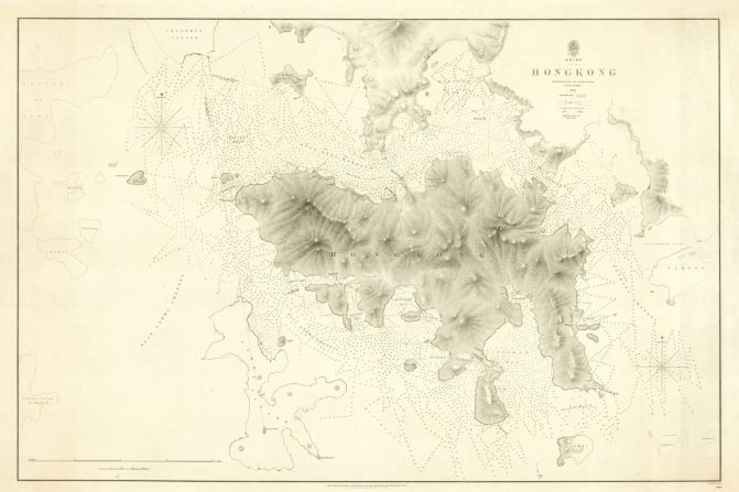
Founded in 1795 by King George III, the British Hydrographic Office produced sea charts and were allowed to sell them to the public. This Admiralty chart was published by Sir Edward Belcher, a British naval officer and explorer involved in the First China War and the capture of Hong Kong.
'First British Survey of Hong Kong,' 1843 —
Founded in 1795 by King George III, the British Hydrographic Office produced sea charts and were allowed to sell them to the public. This Admiralty chart was published by Sir Edward Belcher, a British naval officer and explorer involved in the First China War and the capture of Hong Kong.
courtesy daniel crouch
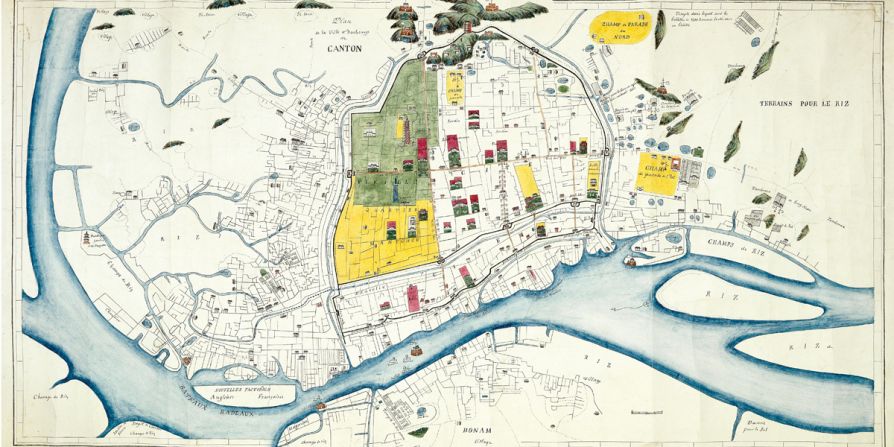
This detailed manuscript plan of Canton (Guangzhou) depicts the city at the end of the Second Opium War. Shown beyond the city walls to the right are parade grounds, numerous hospices and a leper colony.
'Ville et Faubourgs de Canton,' 1860 —
This detailed manuscript plan of Canton (Guangzhou) depicts the city at the end of the Second Opium War. Shown beyond the city walls to the right are parade grounds, numerous hospices and a leper colony.
courtesy daniel crouch
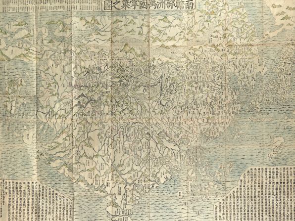
This woodblock is the first Buddhist world map printed in Japan and the prototype for all subsequent Buddhist world maps printed in Japan until the late 19th century. As an amazing example of Buddhist cosmology combined with real world cartography, the map shows a large India, where Buddha was born, as the heart of the world and echoes the pilgrimage route of famous Chinese Buddhist priest Hsuan-Tsang who traveled to India to visit sacred Buddhist places.
'Nansenbushu bankoku shoka no zu,' 1710 —
This woodblock is the first Buddhist world map printed in Japan and the prototype for all subsequent Buddhist world maps printed in Japan until the late 19th century. As an amazing example of Buddhist cosmology combined with real world cartography, the map shows a large India, where Buddha was born, as the heart of the world and echoes the pilgrimage route of famous Chinese Buddhist priest Hsuan-Tsang who traveled to India to visit sacred Buddhist places.
courtesy daniel crouch
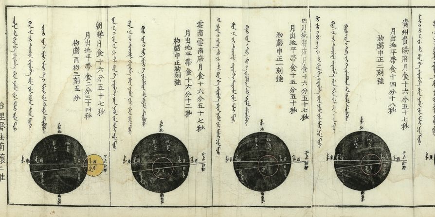
This woodcut, printed in three colors on mulberry paper, was drawn by Felmish born Jesuit missionary to China Ferdinand Verbiest, who was also a mathematician and astronomer. The map shows Verbiest's prognostication for the lunar eclipse of March 25, 1671, which the emperor wanted six months in advance in order to notify the regions of the empire in time. The scroll shows the phases of the eclipse in 17 drawings -- one for each province, and illustrates his attempt to show the superiority of European science over traditional Chinese beliefs.
'Typus eclipsis lunae,' 1671 —
This woodcut, printed in three colors on mulberry paper, was drawn by Felmish born Jesuit missionary to China Ferdinand Verbiest, who was also a mathematician and astronomer. The map shows Verbiest's prognostication for the lunar eclipse of March 25, 1671, which the emperor wanted six months in advance in order to notify the regions of the empire in time. The scroll shows the phases of the eclipse in 17 drawings -- one for each province, and illustrates his attempt to show the superiority of European science over traditional Chinese beliefs.
courtesy daniel crouch
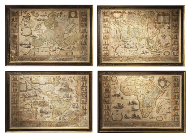
Amsterdam globemaker Willem Blaeu's wall maps are considered to be among the most influential and artistically virtuous masterpieces of baroque cartography, and appeared many times in Vermeer's paintings. The map of Africa shows the European conception of the continent at a time when the coastlines had been explored but the interior remained an enigma.
'Wall maps of the four continents,' 1646 —
Amsterdam globemaker Willem Blaeu's wall maps are considered to be among the most influential and artistically virtuous masterpieces of baroque cartography, and appeared many times in Vermeer's paintings. The map of Africa shows the European conception of the continent at a time when the coastlines had been explored but the interior remained an enigma.
courtesy daniel crouch

My Account
  • Settings
  • Newsletters
  • Topics you follow
  • Sign out
Your CNN account Sign in to your CNN account

Live TV Listen Watch
  • World
    • Africa
    • Americas
    • Asia
    • Australia
    • China
    • Europe
    • India
    • Middle East
    • United Kingdom
  • US Politics
    • Trump
    • Facts First
    • CNN Polls
    • Elections 2026
    • Redistricting Tracker
    • Epstein Files
  • Business
    • Tech
    • Media
    • Calculators
    • Videos
  • Markets
    • Pre-markets
    • After-Hours
    • Fear & Greed
    • Investing
  • Health
    • Life, But Better
    • Fitness
    • Food
    • Sleep
    • Mindfulness
    • Relationships
  • Entertainment
    • Movies
    • Television
    • Celebrity
  • Tech
    • Innovate
  • Style
    • Arts
    • Design
    • Fashion
    • Architecture
    • Luxury
    • Beauty
    • Video
  • Travel
    • Destinations
    • Food & Drink
    • Stay
    • News
    • Videos
  • Sports
    • Football
    • Tennis
    • Golf
    • Motorsport
    • US Sports
    • Olympics
  • Science
    • Space
    • Life
    • Unearthed
  • Climate
    • Solutions
    • Weather
  • Weather
    • Video
    • Climate
  • Ukraine-Russia War
  • Israel-Hamas War
  • Features
    • As Equals
    • Call to Earth
    • Freedom Project
    • Impact Your World
    • Inside Africa
    • CNN Heroes
  • Watch
    • Live TV
    • Featured
    • CNN Headlines
    • Shows A-Z
    • CNN 10
    • CNN TV Schedule
  • Listen
    • All There Is with Anderson Cooper
    • Chasing Life with Dr. Sanjay Gupta
    • The Assignment with Audie Cornish
    • Terms of Service with Clare Duffy
    • CNN 5 Things
    • All CNN Podcasts
  • Games
    • Daily Crossword
    • Jumble Crossword
    • Photo Shuffle
    • Sudoblock
    • Sudoku
    • 5 Things Quiz
  • About CNN
    • Photos
    • Investigations
    • CNN Profiles
    • CNN Leadership
    • CNN Newsletters
    • Work for CNN

Watch Listen Live TV
My Account
  • Settings
  • Newsletters
  • Topics you follow
  • Sign out
Your CNN account Sign in to your CNN account
Follow CNN Travel

Download the CNN app

Terms of Use Privacy Policy Ad Choices Accessibility & CC About Newsletters Transcripts Sitemap

© 2026 Cable News Network. A Warner Bros. Discovery Company. All Rights Reserved.
CNN Sans ™ & © 2016 Cable News Network.

Download the CNN app

Scan the QR code to download the CNN app on Google Play.

Scan the QR code to download the CNN app from Google Play.

Download the CNN app

Scan the QR code to download the CNN app from the Apple Store.

Scan the QR code to download the CNN app from the Apple Store.