These cities were built to be capitals | CNN

CNN values your feedback

1. How relevant is this ad to you?
2. Did you encounter any technical issues?
Thank You!
Your effort and contribution in providing this feedback is much appreciated.
Close
Ad Feedback
Arts
Design
Fashion
Architecture
Luxury
Beauty
Video
More
Arts Design Fashion Architecture Luxury Beauty Video
Watch Listen Live TV
My Account
  • Settings
  • Newsletters
  • Topics you follow
  • Sign out
Your CNN account Sign in to your CNN account

My Account
  • Settings
  • Newsletters
  • Topics you follow
  • Sign out
Your CNN account Sign in to your CNN account

Live TV Listen Watch
Edition
US
International
Arabic
Español
Edition
  • US
  • International
  • Arabic
  • Español

Arts
Design
Fashion
Architecture
Luxury
Beauty
Video

Follow CNN Style
Download the CNN App

  • World
    • Africa
    • Americas
    • Asia
    • Australia
    • China
    • Europe
    • India
    • Middle East
    • United Kingdom
  • US Politics
    • Elections 2026
    • Trump
    • Facts First
    • CNN Polls
    • Redistricting Tracker
    • Epstein Files
  • Business
    • Tech
    • Media
    • Calculators
    • Videos
  • Markets
    • Pre-markets
    • After-Hours
    • Fear & Greed
    • Investing
    • Markets Now
    • Nightcap
  • Health
    • Life, But Better
    • Fitness
    • Food
    • Sleep
    • Mindfulness
    • Relationships
  • Entertainment
    • Movies
    • Television
    • Celebrity
  • Tech
    • Innovate
  • Style
    • Arts
    • Design
    • Fashion
    • Architecture
    • Luxury
    • Beauty
    • Video
  • Travel
    • Destinations
    • Food & Drink
    • Stay
    • News
    • Videos
  • Sports
    • Football
    • Tennis
    • Golf
    • Motorsport
    • US Sports
    • Olympics
  • Science
    • Space
    • Life
    • Unearthed
  • Climate
    • Solutions
    • Weather
  • Weather
    • Video
    • Climate
  • World Cup 2026
  • Ukraine-Russia War
  • Israel-Hamas War
  • Features
    • As Equals
    • Call to Earth
    • Freedom Project
    • Impact Your World
    • Inside Africa
    • CNN Heroes
  • Watch
    • Live TV
    • Featured
    • CNN Fast
    • Shows A-Z
    • CNN 10
    • CNN TV Schedule
  • Listen
    • All There Is with Anderson Cooper
    • Chasing Life with Dr. Sanjay Gupta
    • The Assignment with Audie Cornish
    • Terms of Service with Clare Duffy
    • CNN 5 Things
    • All CNN Podcasts
  • Games
    • Daily Crossword
    • Jumble Crossword
    • Photo Shuffle
    • Sudoblock
    • Sudoku
    • 5 Things Quiz
  • About CNN
    • Photos
    • Investigations
    • CNN Profiles
    • CNN Leadership
    • CNN Newsletters
    • Work for CNN

Download the CNN App

These cities were built to be capitals

Updated 5:50 AM EDT, Sun September 29, 2019
Link Copied!
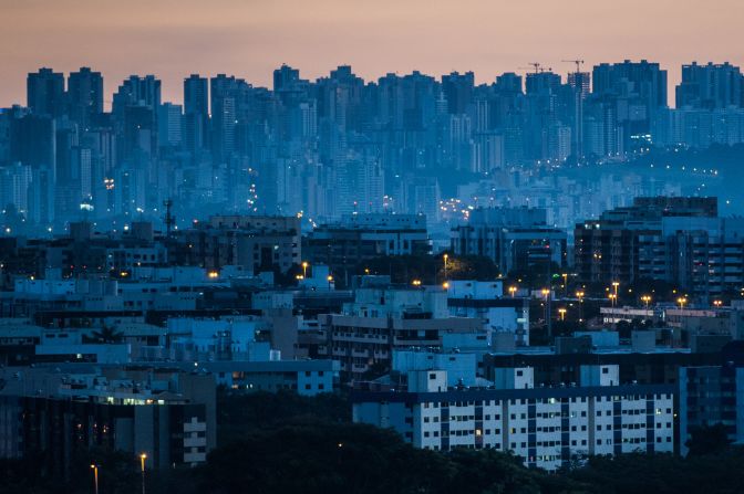
Brasilia, the capital of Brazil, is one of many capital cities in the world that was designed and built for that exact purpose. The idea that the capital should be moved from Rio de Janeiro to somewhere closer to the country's geographical center was included in <a href="index.php?page=&url=https%3A%2F%2Fwww.usip.org%2Fsites%2Fdefault%2Ffiles%2FFraming%2520the%2520State%2FChapter16_Framing.pdf" target="_blank" target="_blank">Brazil's constitution in 1891</a>, although construction only began in the 1950s, under the lead of newly-elected president, Juscelino Kubitschek. The city was planned out by Brazilian architect Lucio Costa -- who designed a layout in the shape of a plane, or a bird in flight -- with key buildings by famed architect Oscar Niemeyer. Residential areas were organized into "superquadras<em>"</em> ("superblocks"), each designed to function as a self-contained neighborhood. An <a href="index.php?page=&url=http%3A%2F%2Fwww.brazil.gov.br%2Fabout-brazil%2Fnews%2F2016%2F09%2Fmeet-brasilia-the-young-capital-of-the-country" target="_blank" target="_blank">artificial lake </a>was built, as were as thousands of miles of highway, which facilitated access to the city, but also to the Amazon rainforest, accelerating deforestation. Over time, the city has struggled to adapt to its growth and has <a href="index.php?page=&url=https%3A%2F%2Fwww.smartcitiesdive.com%2Fex%2Fsustainablecitiescollective%2Funeven-development-planned-cities-brasilia%2F121571%2F" target="_blank" target="_blank">split in two</a>, with the affluent center -- closer to the original plan -- now surrounded by a sprawling periphery where poorer people live in far from ideal conditions.
Brasilia (Brazil) —
Brasilia, the capital of Brazil, is one of many capital cities in the world that was designed and built for that exact purpose. The idea that the capital should be moved from Rio de Janeiro to somewhere closer to the country's geographical center was included in Brazil's constitution in 1891, although construction only began in the 1950s, under the lead of newly-elected president, Juscelino Kubitschek. The city was planned out by Brazilian architect Lucio Costa -- who designed a layout in the shape of a plane, or a bird in flight -- with key buildings by famed architect Oscar Niemeyer. Residential areas were organized into "superquadras" ("superblocks"), each designed to function as a self-contained neighborhood. An artificial lake was built, as were as thousands of miles of highway, which facilitated access to the city, but also to the Amazon rainforest, accelerating deforestation. Over time, the city has struggled to adapt to its growth and has split in two, with the affluent center -- closer to the original plan -- now surrounded by a sprawling periphery where poorer people live in far from ideal conditions.
YASUYOSHI CHIBA/AFP/AFP/Getty Images
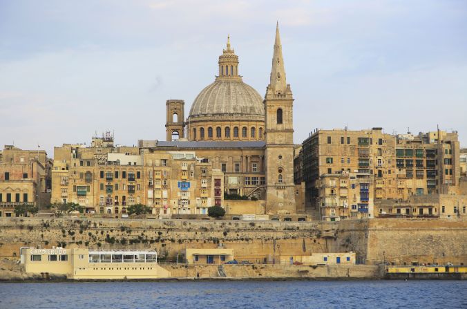
The smallest and southernmost capital city in Europe, Valletta was built after the Great Siege of Malta<a href="index.php?page=&url=https%3A%2F%2Fwww.visitmalta.com%2Fen%2Fvalletta-history" target="_blank" target="_blank"> in 1565</a>. The city was named after Jean de Valette, the victorious Grand Master, and designed by Italian architect Francesco Laparelli, who chose a rectangular grid plan. It was <a href="index.php?page=&url=https%3A%2F%2Fwhc.unesco.org%2Fen%2Flist%2F131%2F" target="_blank" target="_blank">designated </a>a UNESCO World Heritage site in 1980. A new Parliament House was designed by Italian architect Renzo Piano and completed in 2015. Today the city has a population of about 450,000 people.
Valletta (Malta) —
The smallest and southernmost capital city in Europe, Valletta was built after the Great Siege of Malta in 1565. The city was named after Jean de Valette, the victorious Grand Master, and designed by Italian architect Francesco Laparelli, who chose a rectangular grid plan. It was designated a UNESCO World Heritage site in 1980. A new Parliament House was designed by Italian architect Renzo Piano and completed in 2015. Today the city has a population of about 450,000 people.
Geography Photos/UIG/Getty Images
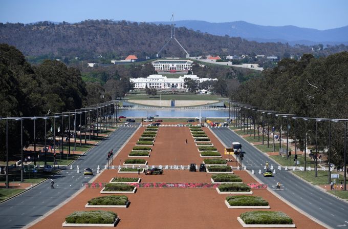
In 1911, a worldwide <a href="index.php?page=&url=http%3A%2F%2Fguides.naa.gov.au%2Frecords-about-act%2Fpart1%2Fchapter2%2F2.5.aspx" target="_blank" target="_blank">competition</a> was launched to design the new Australian capital, and construction began two years later based on the winning plan by American architect <a href="index.php?page=&url=http%3A%2F%2Fwww.naa.gov.au%2Fcollection%2Ffact-sheets%2Ffs95.aspx" target="_blank" target="_blank">Walter Burley Griffin</a>. The plan included geometric motifs and an abundance of green spaces. Capital city status was officially transferred from Melbourne to Canberra <a href="index.php?page=&url=https%3A%2F%2Fcanberra.com.au%2Fcanberra-australias-capital-city%2F" target="_blank" target="_blank">in 1927</a>. Canberra has been expanding ever since, although <a href="index.php?page=&url=http%3A%2F%2Fwww.population.net.au%2Fcanberra-population%2F" target="_blank" target="_blank">fewer than 400,000</a> people call it home.
Canberra (Australia) —
In 1911, a worldwide competition was launched to design the new Australian capital, and construction began two years later based on the winning plan by American architect Walter Burley Griffin. The plan included geometric motifs and an abundance of green spaces. Capital city status was officially transferred from Melbourne to Canberra in 1927. Canberra has been expanding ever since, although fewer than 400,000 people call it home.
Tracey Nearmy/Getty Images
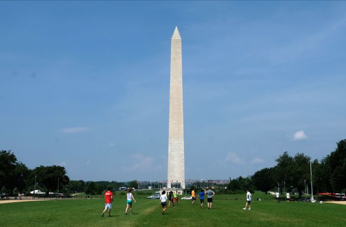
In 1790, the US Congress <a href="index.php?page=&url=https%3A%2F%2Fwww.heritage.org%2Freport%2Fthe-constitution-and-the-district-columbia" target="_blank" target="_blank">set aside</a> the District of Columbia for a city that would host the federal government. It was named in honor of President George Washington, who signed the bill into law. The city was planned by French architect Pierre Charles L'Enfant. His work was <a href="index.php?page=&url=http%3A%2F%2Fblogs.umb.edu%2Fbuildingtheworld%2Ffounding-of-new-cities%2Fthe-founding-of-washington-d-c-united-states%2F" target="_blank" target="_blank">controversial</a>, and in the early 1900s it was revised by a specially formed committee of architects and planners. The resulting McMillan Plan changed the vision of the city significantly, especially its monuments and parks. A <a href="index.php?page=&url=https%3A%2F%2Fwww.nps.gov%2Fnr%2Ftravel%2Fwash%2Flenfant.htm" target="_blank" target="_blank">height restriction </a>for all buildings makes Washington unique among large US cities. The Washington Monument is <a href="index.php?page=&url=https%3A%2F%2Fwww.cnn.com%2F2019%2F09%2F19%2Fpolitics%2Fmelania-trump-washington-monument%2Findex.html" target="_blank">the world's tallest, free-standing masonry structure</a>, at 555 feet or 169 meters.
Washington, DC (United States) —
In 1790, the US Congress set aside the District of Columbia for a city that would host the federal government. It was named in honor of President George Washington, who signed the bill into law. The city was planned by French architect Pierre Charles L'Enfant. His work was controversial, and in the early 1900s it was revised by a specially formed committee of architects and planners. The resulting McMillan Plan changed the vision of the city significantly, especially its monuments and parks. A height restriction for all buildings makes Washington unique among large US cities. The Washington Monument is the world's tallest, free-standing masonry structure, at 555 feet or 169 meters.
Alex Wroblewski/Getty Images
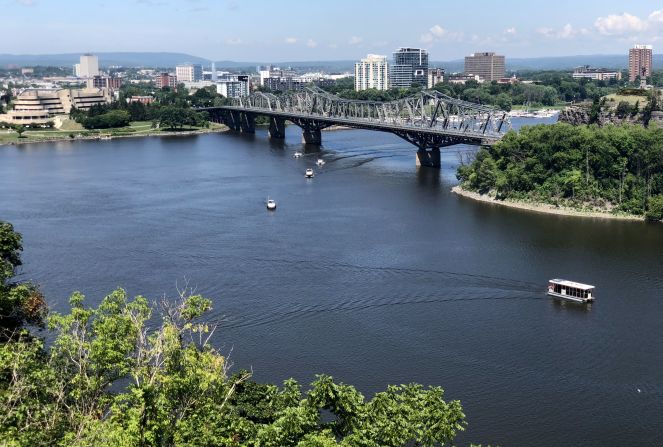
Before being named the capital of the then British colony Province of Canada in 1857, Ottawa was a small lumbering town. It was <a href="index.php?page=&url=https%3A%2F%2Flop.parl.ca%2Fabout%2Fparliament%2Feducation%2Fourcountryourparliament%2Fhtml_booklet%2Fwhy-ottawa-e.html" target="_blank" target="_blank">selected</a> for its location right on the boundary between the country's French-speaking and English-speaking areas. In 1950 it was significantly <a href="index.php?page=&url=http%3A%2F%2Fspacing.ca%2Fottawa%2F2009%2F12%2F22%2Fthe-greber-plan-a-ghost-of-ottawa-past%2F" target="_blank" target="_blank">updated</a> via the Greber Plan, named after French architect Jacques Greber, who set out to make the city more aesthetically pleasant and responsive to the requirements of a capital. Greber created a <a href="index.php?page=&url=http%3A%2F%2Fpublications.gc.ca%2Fcollections%2Fcollection_2014%2Fccn-ncc%2FW93-32-2013-eng.pdf" target="_blank" target="_blank">greenbelt</a> around the city, while removing the street car system and industrial buildings from the center. The city's Rideau Canal, which connects Ottawa to Lake Ontario, was designated a UNESCO World Heritage site in 2007.
Ottawa (Canada) —
Before being named the capital of the then British colony Province of Canada in 1857, Ottawa was a small lumbering town. It was selected for its location right on the boundary between the country's French-speaking and English-speaking areas. In 1950 it was significantly updated via the Greber Plan, named after French architect Jacques Greber, who set out to make the city more aesthetically pleasant and responsive to the requirements of a capital. Greber created a greenbelt around the city, while removing the street car system and industrial buildings from the center. The city's Rideau Canal, which connects Ottawa to Lake Ontario, was designated a UNESCO World Heritage site in 2007.
DANIEL SLIM/AFP/AFP/Getty Images
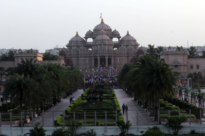
In 1911, King George V, then Emperor of India, <a href="index.php?page=&url=https%3A%2F%2Fwww.ncbi.nlm.nih.gov%2Fpmc%2Farticles%2FPMC5836341%2F" target="_blank" target="_blank">declared</a> that the capital of the British Raj -- the UK's rule over the Indian subcontinent that lasted from 1858 to 1947 -- would be moved from Calcutta to Delhi. He laid the foundation stone of New Delhi about three miles south of the center of the existing city of Delhi. The new capital was inaugurated in 1931 and was designed by British architects with wide avenues and grid patterns that were in stark contrast with the narrow and twisting roads of Old Delhi. To this day, the two cities are distinct, with New Delhi -- the capital of independent India since 1947 -- in the south, and the much larger historic city of Old Delhi in the north. The greater metropolitan area is generally called Delhi and is home to over <a href="index.php?page=&url=https%3A%2F%2Funchronicle.un.org%2Farticle%2Fdelhi-forever-city" target="_blank" target="_blank">16 million people</a>.
New Delhi (India) —
In 1911, King George V, then Emperor of India, declared that the capital of the British Raj -- the UK's rule over the Indian subcontinent that lasted from 1858 to 1947 -- would be moved from Calcutta to Delhi. He laid the foundation stone of New Delhi about three miles south of the center of the existing city of Delhi. The new capital was inaugurated in 1931 and was designed by British architects with wide avenues and grid patterns that were in stark contrast with the narrow and twisting roads of Old Delhi. To this day, the two cities are distinct, with New Delhi -- the capital of independent India since 1947 -- in the south, and the much larger historic city of Old Delhi in the north. The greater metropolitan area is generally called Delhi and is home to over 16 million people.
Mayank Makhija/NurPhoto/Getty Images
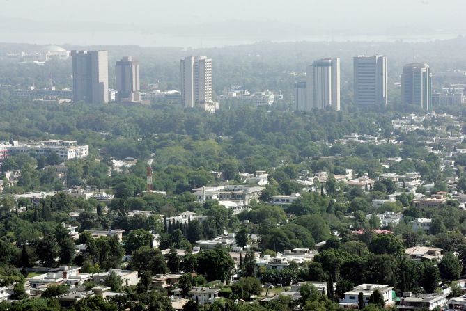
Islamabad (meaning "city of Islam") replaced Karachi as Pakistan's capital<a href="index.php?page=&url=http%3A%2F%2Fwww.cda.gov.pk%2Fabout_islamabad%2Fhistory%2F%23ad-image-0" target="_blank" target="_blank"> in 1963 </a>after three years of construction. The master plan was designed by Greek architect Constantinos Doxiadis, and the city is divided into <a href="index.php?page=&url=https%3A%2F%2Fwww.google.com%2Furl%3Fsa%3Dt%26rct%3Dj%26q%3D%26esrc%3Ds%26source%3Dweb%26cd%3D26%26cad%3Drja%26uact%3D8%26ved%3D2ahUKEwi7zN6H6-nkAhWHasAKHQvKDecQFjAZegQIARAB%26url%3Dhttps%253A%252F%252Fwww.britannica.com%252Fplace%252FIslamabad%26usg%3DAOvVaw3nMqGIPOVQ6k2x19PZNUCB" target="_blank" target="_blank">eight zones</a>: administrative, commercial, education, industrial, diplomatic, residential, rural and green. With a population of around 1 million people, Islamabad is Pakistan's ninth largest city.
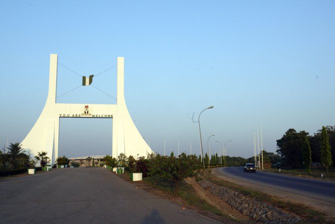
Islamabad (Pakistan) —
Islamabad (meaning "city of Islam") replaced Karachi as Pakistan's capital in 1963 after three years of construction. The master plan was designed by Greek architect Constantinos Doxiadis, and the city is divided into eight zones: administrative, commercial, education, industrial, diplomatic, residential, rural and green. With a population of around 1 million people, Islamabad is Pakistan's ninth largest city.
AAMIR QURESHI/AFP/AFP/Getty Images
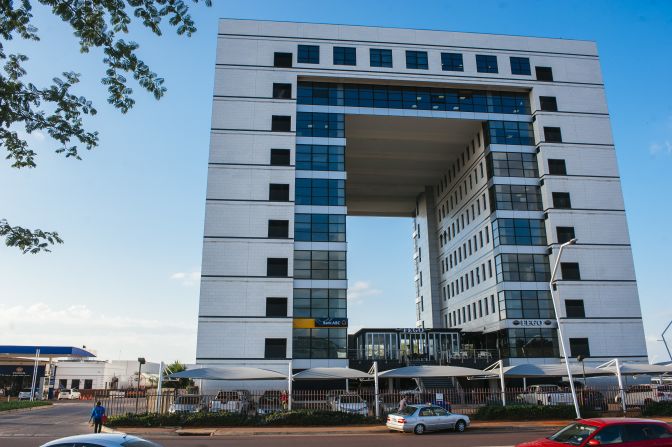
Abuja replaced Lagos as the capital city of Nigeria in 1991. The country had wanted to create a capital city that represented unity and neutrality, and for that reason a location at the center of the country was chosen, with abundant space for expansion and a cooler climate compared to Lagos. Abuja was the fastest growing city in the world between 2000 and 2010, <a href="index.php?page=&url=https%3A%2F%2Fweb.archive.org%2Fweb%2F20151117022953%2Fhttp%3A%2F%2Fblog.euromonitor.com%2F2010%2F03%2Fspecial-report-worlds-fastest-growing-cities-are-in-asia-and-africa.html" target="_blank" target="_blank">according to the UN</a>, and its metropolitan area is now home to nearly 3 million people. The master plan for the city was created by a team of designers including famed Japanese modernist architect <a href="index.php?page=&url=https%3A%2F%2Foma.eu%2Fprojects%2Fabuja-aist" target="_blank" target="_blank">Kenzo Tange</a>.
Abuja (Nigeria) —
Abuja replaced Lagos as the capital city of Nigeria in 1991. The country had wanted to create a capital city that represented unity and neutrality, and for that reason a location at the center of the country was chosen, with abundant space for expansion and a cooler climate compared to Lagos. Abuja was the fastest growing city in the world between 2000 and 2010, according to the UN, and its metropolitan area is now home to nearly 3 million people. The master plan for the city was created by a team of designers including famed Japanese modernist architect Kenzo Tange.
Pius Utomi Ekpei/AFP/Getty Images
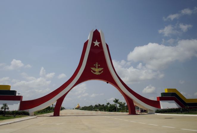
Gaberones became the capital of Botswana in 1965, one year before the country declared its independence from Britain. The name was changed to Gaborone in 1969. Its design is based on "<a href="index.php?page=&url=https%3A%2F%2Fwww.academia.edu%2F3092059%2FNew_towns_in_Africa_Modernity_and_or_Decentralization" target="_blank" target="_blank">garden city</a>" principles, which prioritize wide streets and green areas. The city has experienced rapid urbanization in recent decades and now stretches <a href="index.php?page=&url=https%3A%2F%2Fwww.pahor.de%2Fmaps-and-prints%2Fbotswana-gaborone-urbanism-gaborone-town-plan.html" target="_blank" target="_blank">beyond the borders of the city's original plan.</a>
Gaborone (Botswana) —
Gaberones became the capital of Botswana in 1965, one year before the country declared its independence from Britain. The name was changed to Gaborone in 1969. Its design is based on "garden city" principles, which prioritize wide streets and green areas. The city has experienced rapid urbanization in recent decades and now stretches beyond the borders of the city's original plan.
Waldo Swiegers/Bloomberg/Getty Images
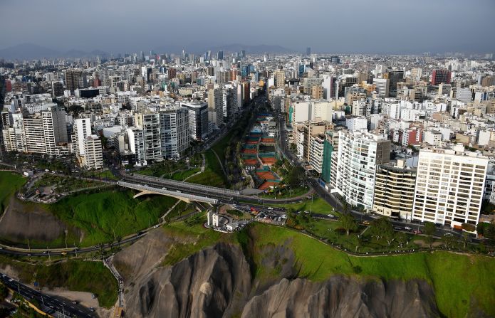
The most recent of planned capital cities is Naypyidaw (also known as Nay Pyi Taw), which replaced Yangon as Myanmar's capital<a href="index.php?page=&url=https%3A%2F%2Fwww.cnn.com%2F2013%2F07%2F30%2Fworld%2Fasia%2Fmyanmar-fast-facts%2Findex.html" target="_blank"> in 2006</a>. For years, the city's large avenues were largely devoid of traffic, and the roads were lined with government buildings, luxury hotels and houses. However, <a href="index.php?page=&url=http%3A%2F%2Fwww.dop.gov.mm%2Fen%2Fstate-region%2Fnaypyitaw" target="_blank" target="_blank">official government data</a> now reports that around 1 million residents live in the metropolitan area.
Naypyidaw (Myanmar) —
The most recent of planned capital cities is Naypyidaw (also known as Nay Pyi Taw), which replaced Yangon as Myanmar's capital in 2006. For years, the city's large avenues were largely devoid of traffic, and the roads were lined with government buildings, luxury hotels and houses. However, official government data now reports that around 1 million residents live in the metropolitan area.
Stan Honda/AFP/Getty Images
Lima was founded as the Spanish city of Ciudad de los Reyes ("City of the Kings") in 1535 by Francisco Pizarro, the conquistador who defeated the Inca chief Atahuallpa, leading to the Spanish conquest of Peru. When the Viceroyalty of Peru was established in 1543, Lima was chosen as the capital, as its location on the coast made contact with Spain easier. It remained the nation's capital after Peru obtained independence in the 19th century. The city's historic center was designated a UNESCO site in 1988, and its long history has resulted in a wide range of <a href="index.php?page=&url=https%3A%2F%2Fwhc.unesco.org%2Fen%2Flist%2F500%2F" target="_blank" target="_blank">architectural styles</a>, from Spanish Baroque to Art Nouveau.
Lima (Peru) —
Lima was founded as the Spanish city of Ciudad de los Reyes ("City of the Kings") in 1535 by Francisco Pizarro, the conquistador who defeated the Inca chief Atahuallpa, leading to the Spanish conquest of Peru. When the Viceroyalty of Peru was established in 1543, Lima was chosen as the capital, as its location on the coast made contact with Spain easier. It remained the nation's capital after Peru obtained independence in the 19th century. The city's historic center was designated a UNESCO site in 1988, and its long history has resulted in a wide range of architectural styles, from Spanish Baroque to Art Nouveau.
Franck Fife/AFP/Getty Images
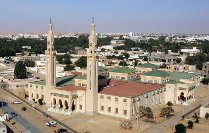
The northwest African country of Mauritania chose the small coastal fishing village of Nouakchott to become its new capital, after it gained independence from France in 1960. The choice was mainly due to the town's location between Saint-Louis in Senegal, from where the former French colony was administered, and its then largest city, Nouadhibou. Originally designed to house a population of <a href="index.php?page=&url=https%3A%2F%2Fbooks.google.co.uk%2Fbooks%3Fid%3D-KU_9MfXKKYC%26pg%3DPA369%26lpg%3DPA369%26dq%3DNouakchott%2Bdesigned%2Bfor%2B15%2C000%2Bpeople%26source%3Dbl%26ots%3DnVi5ZPL7dR%26sig%3DACfU3U37CXGXOKB2YYi-axcGTeSoGwk9dw%26hl%3Den%26sa%3DX%26ved%3D2ahUKEwjDx4eu6-nkAhWkQEEAHSW7ClYQ6AEwCnoECAoQAQ%23v%3Donepage%26q%3DNouakchott%2520designed%2520for%252015%252C000%2520people%26f%3Dfalse" target="_blank" target="_blank">just 15,000 people,</a> the city has grown into the largest city in the country and now has a population of about 1 million. This growth has been spurred mostly by the <a href="index.php?page=&url=https%3A%2F%2Fwww.who.int%2Ffeatures%2F2013%2Fmauritania_environmental_health%2Fen%2F" target="_blank" target="_blank">displacement</a> of Mauritanians due to droughts and desertification.
Nouakchott (Mauritania) —
The northwest African country of Mauritania chose the small coastal fishing village of Nouakchott to become its new capital, after it gained independence from France in 1960. The choice was mainly due to the town's location between Saint-Louis in Senegal, from where the former French colony was administered, and its then largest city, Nouadhibou. Originally designed to house a population of just 15,000 people, the city has grown into the largest city in the country and now has a population of about 1 million. This growth has been spurred mostly by the displacement of Mauritanians due to droughts and desertification.

AFP/AFP/AFP/Getty Images

My Account
  • Settings
  • Newsletters
  • Topics you follow
  • Sign out
Your CNN account Sign in to your CNN account

Live TV Listen Watch
  • World
    • Africa
    • Americas
    • Asia
    • Australia
    • China
    • Europe
    • India
    • Middle East
    • United Kingdom
  • US Politics
    • Trump
    • Facts First
    • CNN Polls
    • Elections 2026
    • Redistricting Tracker
    • Epstein Files
  • Business
    • Tech
    • Media
    • Calculators
    • Videos
  • Markets
    • Pre-markets
    • After-Hours
    • Fear & Greed
    • Investing
    • Markets Now
    • Nightcap
  • Health
    • Life, But Better
    • Fitness
    • Food
    • Sleep
    • Mindfulness
    • Relationships
  • Entertainment
    • Movies
    • Television
    • Celebrity
  • Tech
    • Innovate
  • Style
    • Arts
    • Design
    • Fashion
    • Architecture
    • Luxury
    • Beauty
    • Video
  • Travel
    • Destinations
    • Food & Drink
    • Stay
    • News
    • Videos
  • Sports
    • Football
    • Tennis
    • Golf
    • Motorsport
    • US Sports
    • Olympics
  • Science
    • Space
    • Life
    • Unearthed
  • Climate
    • Solutions
    • Weather
  • Weather
    • Video
    • Climate
  • World Cup 2026
  • Ukraine-Russia War
  • Israel-Hamas War
  • Features
    • As Equals
    • Call to Earth
    • Freedom Project
    • Impact Your World
    • Inside Africa
    • CNN Heroes
  • Watch
    • Live TV
    • Featured
    • CNN Headlines
    • Shows A-Z
    • CNN 10
    • CNN TV Schedule
  • Listen
    • All There Is with Anderson Cooper
    • Chasing Life with Dr. Sanjay Gupta
    • The Assignment with Audie Cornish
    • Terms of Service with Clare Duffy
    • CNN 5 Things
    • All CNN Podcasts
  • Games
    • Daily Crossword
    • Jumble Crossword
    • Photo Shuffle
    • Sudoblock
    • Sudoku
    • 5 Things Quiz
  • About CNN
    • Photos
    • Investigations
    • CNN Profiles
    • CNN Leadership
    • CNN Newsletters
    • Work for CNN

Watch Listen Live TV
My Account
  • Settings
  • Newsletters
  • Topics you follow
  • Sign out
Your CNN account Sign in to your CNN account
Follow CNN Style

Download the CNN app

Terms of Use Privacy Policy Ad Choices Accessibility & CC About Newsletters Transcripts

© 2026 Cable News Network. A Warner Bros. Discovery Company. All Rights Reserved.
CNN Sans ™ & © 2016 Cable News Network.

Download the CNN app

Scan the QR code to download the CNN app on Google Play.

Scan the QR code to download the CNN app from Google Play.

Download the CNN app

Scan the QR code to download the CNN app from the Apple Store.

Scan the QR code to download the CNN app from the Apple Store.