Stuff from above | CNN

CNN values your feedback

1. How relevant is this ad to you?
2. Did you encounter any technical issues?
Thank You!
Your effort and contribution in providing this feedback is much appreciated.
Close
Ad Feedback
US
Crime & Justice
More
Crime & Justice
Watch Listen Live TV
My Account
  • Settings
  • Newsletters
  • Topics you follow
  • Sign out
Your CNN account Sign in to your CNN account

My Account
  • Settings
  • Newsletters
  • Topics you follow
  • Sign out
Your CNN account Sign in to your CNN account

Live TV Listen Watch
Edition
US
International
Arabic
Español
Edition
  • US
  • International
  • Arabic
  • Español

Crime & Justice

Follow CNN
Download the CNN App

  • World
    • Africa
    • Americas
    • Asia
    • Australia
    • China
    • Europe
    • India
    • Middle East
    • United Kingdom
  • US Politics
    • Elections 2026
    • Trump
    • Facts First
    • CNN Polls
    • Redistricting Tracker
    • Epstein Files
  • Business
    • Tech
    • Media
    • Calculators
    • Videos
  • Markets
    • Pre-markets
    • After-Hours
    • Fear & Greed
    • Investing
    • Markets Now
    • Nightcap
  • Health
    • Life, But Better
    • Fitness
    • Food
    • Sleep
    • Mindfulness
    • Relationships
  • Entertainment
    • Movies
    • Television
    • Celebrity
  • Tech
    • Innovate
  • Style
    • Arts
    • Design
    • Fashion
    • Architecture
    • Luxury
    • Beauty
    • Video
  • Travel
    • Destinations
    • Food & Drink
    • Stay
    • News
    • Videos
  • Sports
    • Football
    • Tennis
    • Golf
    • Motorsport
    • US Sports
    • Olympics
  • Science
    • Space
    • Life
    • Unearthed
  • Climate
    • Solutions
    • Weather
  • Weather
    • Video
    • Climate
  • World Cup 2026
  • Ukraine-Russia War
  • Israel-Hamas War
  • Features
    • As Equals
    • Call to Earth
    • Freedom Project
    • Impact Your World
    • Inside Africa
    • CNN Heroes
  • Watch
    • Live TV
    • Featured
    • CNN Fast
    • Shows A-Z
    • CNN 10
    • CNN TV Schedule
  • Listen
    • All There Is with Anderson Cooper
    • Chasing Life with Dr. Sanjay Gupta
    • The Assignment with Audie Cornish
    • Terms of Service with Clare Duffy
    • CNN 5 Things
    • All CNN Podcasts
  • Games
    • Daily Crossword
    • Jumble Crossword
    • Photo Shuffle
    • Sudoblock
    • Sudoku
    • 5 Things Quiz
  • About CNN
    • Photos
    • Investigations
    • CNN Profiles
    • CNN Leadership
    • CNN Newsletters
    • Work for CNN

Download the CNN App
Extreme Weather
Extreme Weather
Ad Feedback
U.S.

Stuff from above

Updated 6:23 PM EDT, Sun August 30, 2015
Link Copied!
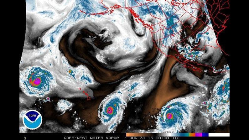
Three hurricanes are spinning in the eastern and central Pacific Ocean. This image shows the water vapor. This is the first time there have been three active hurricanes in the eastern or central Pacific this season, according to NASA. From left the storms are: Hurricane Kilo, Hurricane Ignacio and Hurricane Jimena. Ignacio prompted a tropical storm watch for portions of Hawaii on August 30.
NOAA
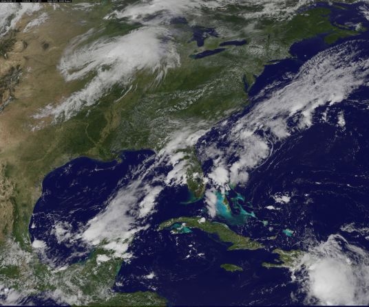
<a href="index.php?page=&url=https%3A%2F%2Fwww.cnn.com%2F2015%2F07%2F24%2Fus%2Fgallery%2Fextreme-climate%2FTropical%2520Storm%2520Erika%2520moves%2520over%2520the%2520Dominican%2520Republic%2520on%2520August%2C%252028%2C%25202015.%2520The%2520storm%2520caused%2520devastation%2520on%2520the%2520Caribbean%2520island%2520of%2520Dominica%2C%2520leaving%2520at%2520least%252012%2520people%2520dead%2520and%2520more%2520than%252020%2520missing.%2520Florida%2520issued%2520a%2520state%2520of%2520emergency%2520as%2520the%2520storm%2520moved%2520toward%2520the%2520South%2520Florida%2520coast." target="_blank">Tropical Storm Erika </a>moves over the Dominican Republic on August 28, 2015. The storm caused devastation on the Caribbean island of Dominica, leaving at least 12 people dead and more than 20 missing. Florida issued a state of emergency as the storm moved toward the South Florida coast.
Tropical Storm Erika moves over the Dominican Republic on August 28, 2015. The storm caused devastation on the Caribbean island of Dominica, leaving at least 12 people dead and more than 20 missing. Florida issued a state of emergency as the storm moved toward the South Florida coast.
NASA GOES Project
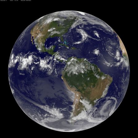
Hurricane Danny can be seen spinning in the Atlantic on August 22, 2015, in this satellite image from the NASA-NOAA GOES Project.
NASA/NOAA GOES PROJECT
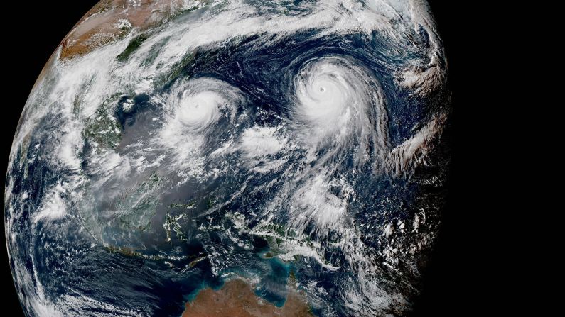
<a href="index.php?page=&url=http%3A%2F%2Fwww.cnn.com%2F2015%2F08%2F20%2Fworld%2Ftwo-typhoons-pacific-asia%2F">Two typhoons, Typhoon Goni and Super Typhoon Atsani, roil over the Pacific in August 2015.</a> Atsani became a super typhoon (equivalent of a Category 4 or 5 storm) on August 19 as it churned northeast of Guam and Saipan.
Two typhoons, Typhoon Goni and Super Typhoon Atsani, roil over the Pacific in August 2015. Atsani became a super typhoon (equivalent of a Category 4 or 5 storm) on August 19 as it churned northeast of Guam and Saipan.
JMA/NOAA/Colorado State University
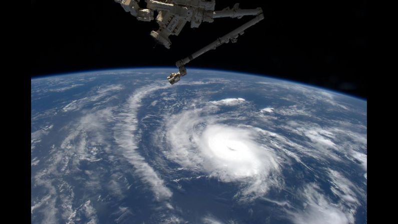
NASA space station astronaut Scott Kelly tweeted this photo of Danny on August 20 just after Danny was classified as the first hurricane in the Atlantic in 2015.
NASA
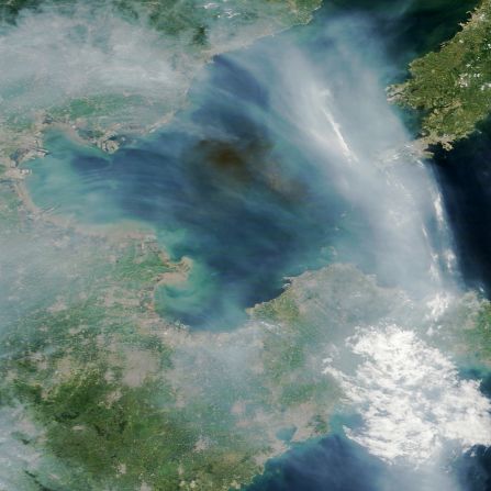
A dark plume of smoke drifts over the Bohai Sea off the east coast of China. The source of the smoke appears to be industrial fires caused by explosions at a port in Tianjin, China. The streams of light gray smoke in the image likely were caused by wildfires in eastern China. NASA's Terra satellite captured the images at 2:30 Universal Time (10:30 a.m. local time) on August 13, 2015.
NASA
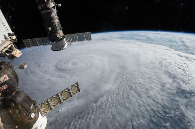
The crew of the International Space Station spotted Typhoon Soudeloron on Wednesday, August 5, 2015, as the storm moved through the western Pacific. You can see two Russian spacecraft hanging below the space station: The Soyuz TMA-17M (left) and the Progress 60 (right) cargo craft. Soudelor became the strongest storm on the planet so far this year, with peak winds at 180 mph (290 kph), according to the Joint Typhoon Warning Center.
NASA
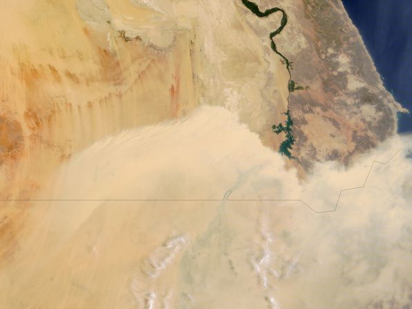
A wall of dust blows north from Sudan toward southern Egypt. This image was taken by NASA's Terra satellite on August 6.
NASA
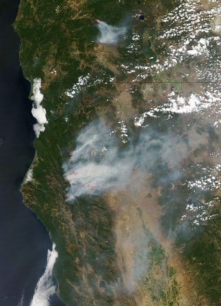
Large wildfires charred more than 6 million acres in the western U.S. in early August  That's nearly 2 million more than the 10-year average. About 80% of the burned area was in remote forests in Alaska, but large fires also scorched parts of Oregon, Washington and northern California. NASA's Aqua satellite took this image of wildfires burning in Oregon and California on August 5. Red outlines indicate the hot spots.
Large wildfires charred more than 6 million acres in the western U.S. in early August That's nearly 2 million more than the 10-year average. About 80% of the burned area was in remote forests in Alaska, but large fires also scorched parts of Oregon, Washington and northern California. NASA's Aqua satellite took this image of wildfires burning in Oregon and California on August 5. Red outlines indicate the hot spots.
NASA
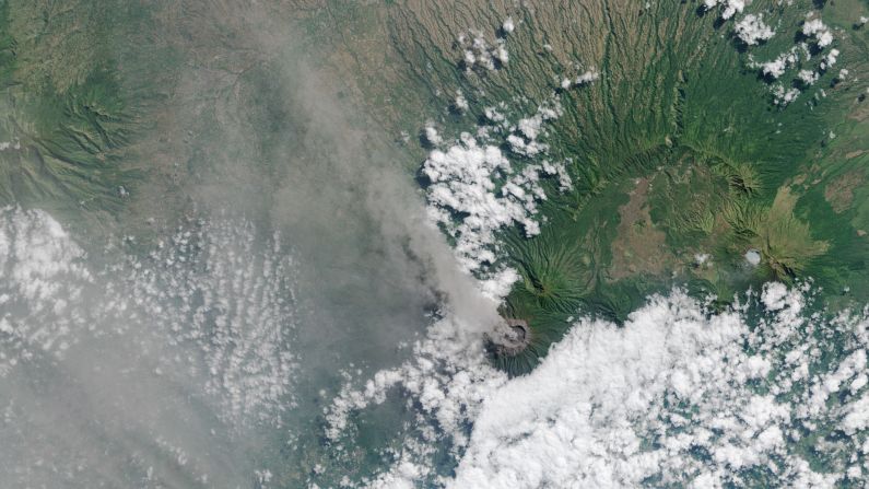
Ash and volcanic gases rise from the Mt. Raung volcano's caldera and drift northwest on the Indonesian island of Java. This image was captured by the Landsat 8 satellite on July 27. Mount Raung erupted at least 13 times in the past 25 years, according to the Smithsonian Global Volcanism program. The most recent eruption has been going for about four weeks. Ash has forced authorities to temporarily cancel flights and close airports.
From NASA
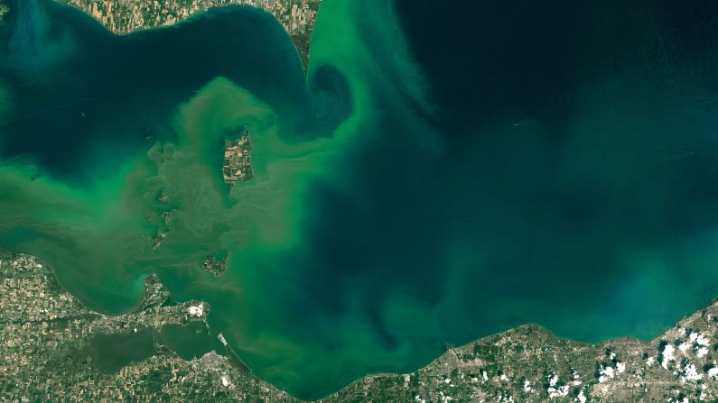
Algae blooms create swirls of green in western Lake Erie in this image taken July 28 by the Landsat 8 satellite. NOAA scientists predicted that the 2015 season for harmful algal blooms would be severe in western Lake Erie and possibly affect water safety. The blooms thrive when exposed to agricultural runoff, sunlight and warm temperatures.
From NASA
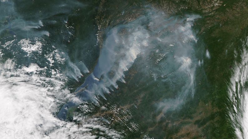
Smoke from fires near the shoreline of Russia's Lake Baikal was captured by NASA's Aqua satellite on July 27. The red spots show where fires were most active. Lake Baikal is the largest freshwater lake by volume in the world, but its water levels have dropped in recent months, according to the Reuters news agency.
From NASA
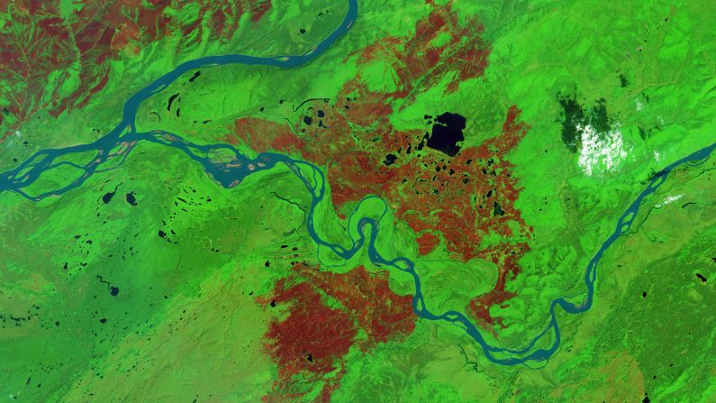
Alaska's Interagency Coordination Center said that 4,748,841 acres in the state had burned in wildfires by July 30. That acreage is enough to make 2015 fourth on the list of years with the most area burned. The record was set in 2004, when 6,590,140 acres burned. The town of Tanana was hardest-hit this year, with about 496,000 acres burned -- that's an area about half the size of Rhode Island. Many of Tanana's 300 residents left in June. The Landsat 8 satellite took this false-color image of the fire-scarred area on July 24, 2015. Burned forest appears brown and unburned forest is green.
From NASA
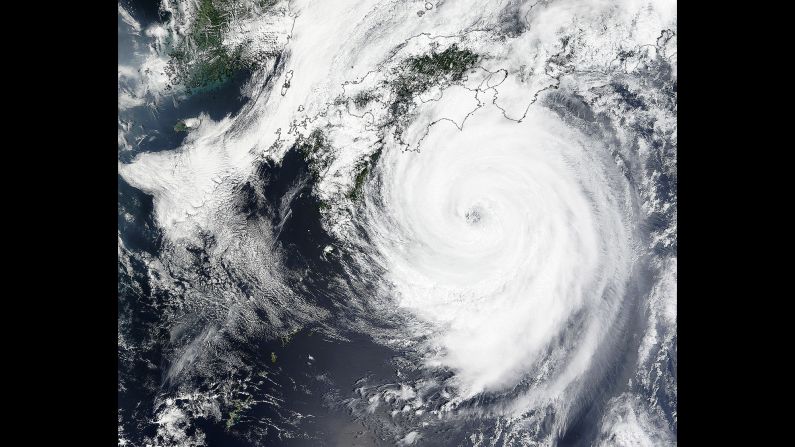
Slow-moving Typhoon Nangka made landfall near Muroto on the Japanese island of Shikoku on July 16. The storm became a typhoon on July 4 and traveled nearly 4,000 kilometers (2,485 miles) across the Pacific Ocean. As the storm closed in, nearly 4,000 residents of Kochi Prefecture were urged to evacuate.
NASA
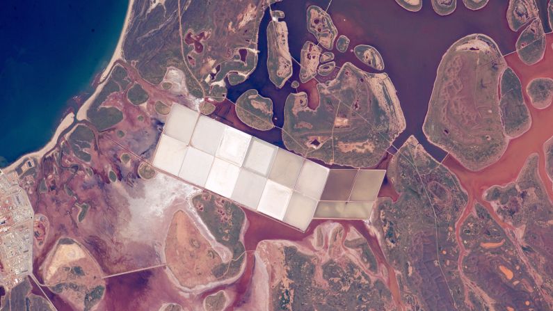
When astronauts look down at Earth from the International Space Station, they use coastlines to help them figure out which part of the planet they're flying over. This photo was taken by a crew member on the space station on June 6. It shows coastal lagoons with rounded islands along the Indian Ocean coastline of Western Australia. You can also see square, white ponds of the salt-extraction industry. This stretch of Australian coast has had more direct hits by cyclones than any other place on the Western Australia's coastline.
NASA
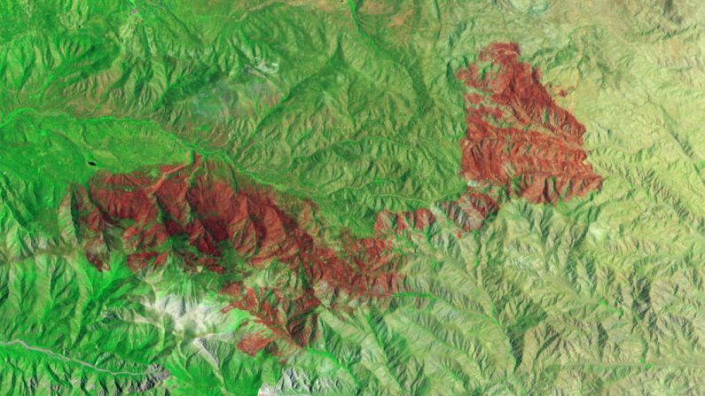
A fire raging in California's San Bernardino National Forest had scorched thousands of acres by early July. NASA's Earth Observing-1 satellite took this false-color image of a burned area spanning 49 square miles (127 square kilometers) on July 3. The burned areas appear dark red because they're reflecting shortwave infrared light.
NASA
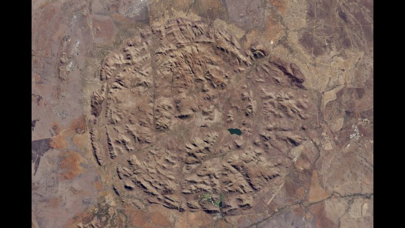
Pilanesberg National Park in North West Province, South Africa, is located in one of the world's largest and best-preserved alkaline ring dike complexes. The circular features were created by an ancient volcano. This image was taken by NASA's Landsat 8 satellite on June 19. Most of the streams that run through the valleys have dried up, but man-made dams have trapped water for the park's wildlife. The structure sits about 300 to 1,600 feet (100 to 500 meters) above the surrounding landscape.
NASA
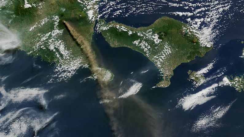
Mt. Raung is seen spewing ash and volcanic gases in this image taken on July 12 by NASA's Aqua satellite. The eruption forced hundreds of flights to and from Bali and other regional airports to be canceled. The ash clouds went as high as 20,000 feet (6 kilometers) into the air.
NASA
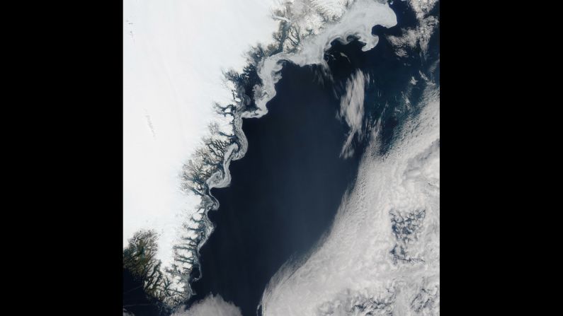
Aqua satellite took this image of sea ice on the eastern coast of Greenland on July 16. The swirls of ice are caused by winds and currents that steer the ice, according to NASA.
NASA
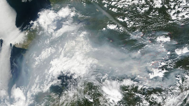
Fires have burned thousands of acres in Alaska. NASA's Terra satellite took this photo of smoke of smoke and haze over Alaska on July 12. Fires are outlined in red. The Alaska Interagency Coordination Center says about 300 fires were actively burning when the image was taken.
NASA
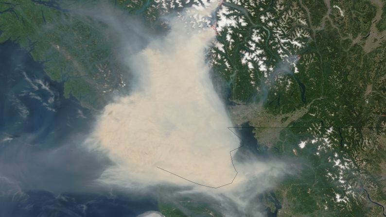
Fires in western Canada sent thick smoke over Vancouver and adjacent areas of British Columbia in early July. Some residents wore face masks for protection and health officials warned Women's World Cup fans against outdoor activities. NASA's Terra satellite captured these images of the smoke July 5 and 6. The smoke almost obscures the Strait of Georgia and southern Vancouver Island.
NASA

My Account
  • Settings
  • Newsletters
  • Topics you follow
  • Sign out
Your CNN account Sign in to your CNN account

Live TV Listen Watch
  • World
    • Africa
    • Americas
    • Asia
    • Australia
    • China
    • Europe
    • India
    • Middle East
    • United Kingdom
  • US Politics
    • Trump
    • Facts First
    • CNN Polls
    • Elections 2026
    • Redistricting Tracker
    • Epstein Files
  • Business
    • Tech
    • Media
    • Calculators
    • Videos
  • Markets
    • Pre-markets
    • After-Hours
    • Fear & Greed
    • Investing
    • Markets Now
    • Nightcap
  • Health
    • Life, But Better
    • Fitness
    • Food
    • Sleep
    • Mindfulness
    • Relationships
  • Entertainment
    • Movies
    • Television
    • Celebrity
  • Tech
    • Innovate
  • Style
    • Arts
    • Design
    • Fashion
    • Architecture
    • Luxury
    • Beauty
    • Video
  • Travel
    • Destinations
    • Food & Drink
    • Stay
    • News
    • Videos
  • Sports
    • Football
    • Tennis
    • Golf
    • Motorsport
    • US Sports
    • Olympics
  • Science
    • Space
    • Life
    • Unearthed
  • Climate
    • Solutions
    • Weather
  • Weather
    • Video
    • Climate
  • World Cup 2026
  • Ukraine-Russia War
  • Israel-Hamas War
  • Features
    • As Equals
    • Call to Earth
    • Freedom Project
    • Impact Your World
    • Inside Africa
    • CNN Heroes
  • Watch
    • Live TV
    • Featured
    • CNN Headlines
    • Shows A-Z
    • CNN 10
    • CNN TV Schedule
  • Listen
    • All There Is with Anderson Cooper
    • Chasing Life with Dr. Sanjay Gupta
    • The Assignment with Audie Cornish
    • Terms of Service with Clare Duffy
    • CNN 5 Things
    • All CNN Podcasts
  • Games
    • Daily Crossword
    • Jumble Crossword
    • Photo Shuffle
    • Sudoblock
    • Sudoku
    • 5 Things Quiz
  • About CNN
    • Photos
    • Investigations
    • CNN Profiles
    • CNN Leadership
    • CNN Newsletters
    • Work for CNN

US
Watch Listen Live TV
My Account
  • Settings
  • Newsletters
  • Topics you follow
  • Sign out
Your CNN account Sign in to your CNN account
Follow CNN

Download the CNN app

Terms of Use Privacy Policy Ad Choices Accessibility & CC About Newsletters Transcripts

© 2026 Cable News Network. A Warner Bros. Discovery Company. All Rights Reserved.
CNN Sans ™ & © 2016 Cable News Network.

Download the CNN app

Scan the QR code to download the CNN app on Google Play.

Scan the QR code to download the CNN app from Google Play.

Download the CNN app

Scan the QR code to download the CNN app from the Apple Store.

Scan the QR code to download the CNN app from the Apple Store.