What we covered here
• Monster storm: Snow and dangerous ice spanned hundreds of miles from Texas to the Northeast.
• Thunder ice: Power outages increased from ice across the South. Thunder and lightning were observed in areas of heavy freezing rain and sleet as the storm intensified overnight.
• Travel nightmare: Over 14,800 flights were canceled because of the storm, a staggering amount. Stretches of interstate were shut down from dangerous road conditions in the storm’s footprint.
• Record cold: More than half of all Americans were forecast to experience subzero wind chills. The extreme cold was expected to lock snow and ice in place and leave those without power shivering for days.
Top videos

Meteorologist Chris Warren checks in with Meteorologist Derek Van Dam in Louisville to see how conditions were as the winter storm progressed.


Meteorologist Chris Warren takes a look at what is still to come as the winter storm continues east.


Harsh winters are nothing new in Boston, but this powerful winter storm could bring the city its heaviest snowfall since 2022.


Nearly 8 inches of snow has fallen across parts of central Arkansas, creating treacherous conditions on roads and causing some accidents, as seen here near Little Rock, Arkansas.


Rachel Heffington of Little Rock, Arkansas, captured this video of a person skiing and two others sledding down a hill outside her house early Saturday morning.


Storm chaser Brian Emfinger captured snowplow crews battling risky conditions in Fayetteville, Arkansas, as heavy snow and thick ice made travel hazardous across the state.

Our live coverage has moved here.
Good samaritans come to the rescue of motorists caught on slippery roads in Texas
As snow and sleet continue falling in Texas, several residents helped push vehicles caught on slippery roads.

These are the highest sleet and ice totals in some states
Sleet has come down fast and furious in some places in this powerful winter storm. Here are some of the highest sleet measurements we have seen thus far in some states:
- Texas: 3.5 inches in Sadler
- Louisiana: 2.7 inches in West Monroe
- Oklahoma: 2.5 inches in Bengal and Lebanon
- Arkansas: 2 inches in Mount Ida
- Alabama: 2 inches in Florence
- Mississippi: 2 inches in Alligator and Hernando
Meanwhile, freezing rain, or rain that freezes on contact with surfaces, has been building up to dangerous levels across parts of the South. Here are some of the biggest ice accretions thus far in some states:
- Louisiana: 0.75 inches at Hall Summit
- Mississippi: 0.5 inches at Inverness
- Oklahoma: 0.5 inches at Idabel
- Texas: 0.5 inches at Cedar Park and Timpson
- New Mexico: 0.3 inches at Roswell
- Tennessee: 0.2 inches at Gatlinburg
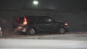
Multiple car accidents in Kentucky amid heavy snow
Heavy snow has led to multiple car accidents at highways in Louisville, Kentucky.
A pick-up truck with a damaged hood was seen idling on the side of a highway. On another road shoulder, a heavy truck was left stationary.
Officials across the country have warned drivers against icy road surfaces and urged people to stay indoors amid the storm.


Oklahoma City residents get creative with snow
In Oklahoma City, one of the hardest hit areas, residents found a way to indulge in fun despite the punishing cold.
They slid down a snow-blanketed slope on their sleds.


Highest snow totals so far
Our massive winter storm has spread snow from the southern Rockies all the way into the Northeast. Here are the highest totals in each state so far, with more on the way:
- Arkansas: 8 inches in Gibson
- Colorado: 23 inches in Crested Butte
- Illinois: 5.6 inches in Glen Carbon
- Indiana: 4.5 inches in Oakland City
- Kansas: 8 inches in Ada and Delphos
- Kentucky: 4.5 inches in Benton
- Missouri: 6 inches in Marshfield, Milan and Saint Joseph
- New Mexico: 13 inches in Bonito Lake
- Oklahoma: 7.5 inches in Porum
- Tennessee: 5 inches in Alamo, Bradford and Millington
- Texas: 6 inches in Hawley
- Virginia: 3 inches in Roanoke
- West Virginia: 2.5 inches in Beckley
West Texas switches over to snow
The National Weather Service in Midland, Texas, sees snow pile up quickly early Sunday morning after the area experienced hours of icing on Saturday.
Don’t let your guard down: Severe storms possible Sunday in the Southeast
This storm has already served up nearly every kind of weather you can imagine — heavy snow, sleet, rain, freezing rain, even thundersleet while winds howled and temperatures plunged. As if that wasn’t enough, there’s one more threat to watch for Sunday.
As dramatically different air masses clash under a powerful jet stream, the Storm Prediction Center has issued a Level 2 of 5 risk of severe thunderstorms for parts of the eastern Gulf Coast states Sunday. Damaging wind gusts are the main concern, but we cannot rule out isolated tornadoes.
Severe weather may be the last thing on your mind during a winter storm, but don’t let your guard down in the Southeast on Sunday.
If you lose power, make sure you have a weather radio or some way to receive severe thunderstorm and tornado warnings.
Here's where the storm is now

The massive storm stretches from the southern Rockies through the Midwest, South and into parts of the mid-Atlantic, where it is knocking on the door of Washington, DC.
Snow (purple shades in the image above) is the most widespread form of precipitation right now, but the icy mix (pinks) is not far behind. Ice is the storm’s most impactful threat as it keeps roads slick and piles up on trees and power lines, weighing them down.
Sleet and freezing rain are expected to spread eastward and increase throughout the evening.
Modified garbage trucks to clear snow in New York amid bus and subway disruptions
Thousands of garbage trucks have been refitted with plows to clear the snow, with workers on standby to combat the blizzard in coming days, New York City Mayor Zohran Mamdani has said.
Efforts to convert the trucks were already under way since Friday while more than 2,000 sanitation workers will be put on call for every 12-hour shift to salt roads as soon as the snowflakes hit, according to Mamdani in a clip posted on X on Saturday.
“Once there’s more than two inches of snow on the ground, plows will roll out across more than 19,000 land miles of roadways and bike ways,” he said.
The Metropolitan Transportation Authority (MTA), which runs the transportation network in New York, has told commuters to “avoid unnecessary travel” on Sunday and Monday, warning that the winter storm may cause delays for buses and cancelations for subway and train services.
In the neighboring state of New Jersey, NJ TRANSIT said it will temporarily suspend all bus, light rail and access link services starting Sunday, including train services connecting New York.
New Jersey’s Transport Department also lowered the speed limit on interstate and state highways to 35mph starting Sunday, it said on Facebook.
Power outages in Mississippi and Louisiana spike
Power outages at Mississippi have tripled over the past two hours, with thousands more in Louisiana also left in the dark, according to a tracking website.
Nearly 70,000 customers in Mississippi have now lost power, according to the latest update from poweroutage.us – up from about 15,000 just two hours ago.
The number of customers in Louisiana who have now gone dark has surged to nearly 70,000, up from 57,000 during that same period of time, the website said.
Texas still has over 50,000 homes and businesses without power and Tennessee’s numbers are at nearly 15,000 and climbing.
The total number of customers without power across the country jumped to more than 235,000 over a 12 hour period, it said.
Sleet to cut into snow totals for parts of the NYC Metro
Forecast snow accumulation was adjusted slightly downward for parts of the New York City metro area, particularly along the coast where the ocean will moderate temperatures. The slightly warmer air will allow more sleet to mix in with the snow earlier than expected, reducing the final totals.
According to the National Weather Service, “Long Island, the NYC Metro, and NE NJ are expected to see 8-12” total, but this may be in the form of 6-9” of snow and 1-2” of sleet.” Inland, 12 to 15 inches of fluffy snow, with an inch or less of sleet mixed in, are still expected.

Thundersleet lights up the radar over Austin, Texas
Residents in Austin heard some rumbles along with the beat of sleet Saturday night. Rising air inside the storm is responsible for these unusual cold-weather flashes.
The National Weather Service reported on X that it detected lightning flashes from the thundersleet in Austin.
College student in Michigan found dead after being reported missing for over a day
A college student last spotted without a coat on a street in Michigan was found dead after having gone missing for more than a day, according to local police.
Lucas Mattson, 19, was last seen walking alone at Hill Street in the city of Ann Arbor at 1am on Friday. His disappearance was later reported to the police.
Officers recovered his body at Cambridge Road around Saturday noon, wrote Ann Arbor’s Police Department in a social media post, also shared by University of Michigan.
“The nearly 20-hour search effort to locate him took place in extreme cold conditions and included officers from AAPD (Ann Arbor’s police department) and University of Michigan Division of Public Safety and Security, as well as the University of Michigan Police Department Drone Unit,” they said.
Mattson sustained “no obvious signs of trauma” with no foul play suspected at this time, though the Washtenaw County Medical Examiner’s Office will further determine the cause of his death, police said.
The temperature in Ann Arbor just past midnight ET on Sunday was 5°F, according to the National Weather Service.
Here's what makes freezing rain, sleet and snow different
Freezing rain will fuel a dangerous, widespread ice threat this weekend.
As the name suggests, freezing rain is simply rain that freezes on contact with cold ground to create ice. This happens when the air at ground level is below freezing — 32 degrees — but the air higher up is warmer.
It’s different from snow, which needs cold air all the way through the atmosphere to make it to the ground and accumulate.
Sleet is the icy midpoint of the other two winter precipitation types. It happens when the precipitation falls through a warm layer in the atmosphere and melts to rain droplets before hitting a layer of cold air close to the ground. The droplets freeze into ice pellets before they hit the ground, unlike freezing rain that freezes when it hits the ground.
Enough sleet still creates slippery conditions, but doesn’t create a sheet of ice like freezing rain.

Here's where the snow is expected to pick up overnight
The Storm Prediction Center has highlighted an area (circled in pink below) where heavy snow bands are expected to ramp up overnight, a bit sooner than forecast guidance indicated.
Snowfall rates of over 1 inch per hour are likely in parts of southern Illinois, southern Indiana, southwestern Ohio and far northern Kentucky. Visibility could be lower than half a mile, making driving extremely hazardous.

Almost 1 in 4 flights handled daily by US aviation authority canceled

The Federal Aviation Administration, which regulates air traffic in the US, handles an average of 44,360 flights per day.
With almost 10,000 flights within, into or out of the US canceled on Sunday, according to FlightAware, that accounts for almost a quarter of the flights processed by the civil aviation body on a daily basis.
Power outages starting to tick up along the Gulf Coast
As ice and sleet work their way across the South, more homes and business are losing power.
Louisiana has over 57,000 customers in the dark and Texas has more than 41,000, according to Poweroutage.us at about 11:45p.m. ET. Mississippi numbers are on the rise as over 15,000 are without power.
Sleet has changed to freezing rain in North Carolina. Here's why that's bad news
Sleet has transitioned to freezing rain faster than expected across North Carolina. Freezing rain builds ice much more efficiently than sleet, so this nudges the forecast toward a higher-impact ice scenario rather than the mix of snow and sleet many were hoping for Saturday night.