August 7, 2024 - Tropical Storm Debby updates | CNN

August 7, 2024 - Tropical Storm Debby updates

rain.jpg
East coast bracing for second wave of historic rains brought by Tropical Storm Debby
01:32 • Source: CNN
01:32

What we covered here

  • Tracking Debby: Tropical Storm Debby is back over the Atlantic, where it is regaining strength and lashing the coast of the Southeast US. The storm is expected to make a second landfall on Thursday on the South Carolina coast. See Debby’s projected path.
  • Historic rainfall: For the next couple of days, the storm is forecast to dump prolific amounts of rain and bring life-threatening flooding along its path. Debby has already turned roads into rivers and swamped homes in parts of Florida, Georgia and South Carolina.
  • Deadly storm: Far-reaching Debby has killed at least four people in Florida and one in Georgia.
  • The role of climate change: Global warming caused by fossil fuel pollution is causing storms to get wetter and strengthen more quickly. Debby tracked through near-record warm waters in the Gulf of Mexico, which helped it rapidly intensify before making landfall as a hurricane in Florida.
  • If you are in an area of low connectivity, get the latest CNN updates here.
33 Posts

Tropical Storm Debby nears the coast of South Carolina

This satellite image, taken at 11:01 pm ET, shows Tropical Storm Debby as it moves along the East Coast of the United States.

Tropical Storm Debby is nearing the South Carolina coastline with maximum sustained winds of 60 mph ahead of its expected landfall early Thursday morning.

Located about 25 miles east-northeast of Charleston, the storm is crawling north-northwest at 3 mph and is expected to weaken after making landfall. 

Rainfall continues to be the main threat for areas impacted by Debby. A high risk for excessive rainfall, or a level 4 of 4, remains for the Carolinas through early Thursday, where rainfall totals across parts of South Carolina could reach as high as 25 inches. 

The high threat shifts to parts of North Carolina and Virginia on Thursday, which will be the fourth consecutive day of a high rainfall risk from Debby. Rainfall totals across North Carolina could reach as high as 15 inches. Parts of Virginia could see 3 to 8 inches with isolated amounts up to 10 inches. 

The threat drops slightly to a moderate risk for excessive rainfall, or a level 3 of 4, on Friday and spreads from eastern portions of West Virginia to much of Vermont. 

The center of the storm is forecast to move into North Carolina by Thursday evening and into northern Virginia by Friday morning. It will continue to pick up speed and is forecast to move through Pennsylvania by Friday evening and through New England by Saturday morning. 

Four tornadoes confirmed in Charleston area from Tropical Storm Debby

Damaged trucks are seen at a car dealer in Moncks Corner, South Carolina, on August 7, after a tornado hit the area.

Four tornadoes have been confirmed on the South Carolina coast as Debby continues to impact the region, according to the National Weather Service in Charleston.

Here is the preliminary information for each of the tornadoes that hit on Monday and Tuesday: 

Edisto Beach:

  • Rating: EF1
  • Max Wind: 97 mph
  • Duration: 9:35 pm - 9:45 pm on August 5

Moncks Corner:

  • Rating: EF1
  • Max Wind: 95 mph
  • Duration: 2:53 am - 3:00 am on August 6

Kiawah Island:

  • Rating: EF0
  • Max wind: 85 mph
  • Duration: 10:55 pm - 10:59 pm on August 5

Ladys Island:

  • Rating: EF0
  • Max Wind: 85 mph
  • Duration: 12:53 am - 12:56 am on August 6

In Florida, there are preliminary reports of eight tornadoes from Debby. A tornado watch also remains active for eastern North Carolina until Thursday morning.

Triple-digit heat indices in the Southeast could slow the recovery process for those impacted by Debby

For parts of the Southeast no longer feeling direct impacts from Debby’s rain bands, potentially dangerous heat is the next concern.

While high temperatures in the upper 80s and lower 90s are expected, the heat indices, or feels-like temperatures, could exceed 110 degrees Fahrenheit. 

The triple-digit heat indices are expected to persist across the region into the weekend, which could further slow the recovery process in Debby’s wake.

Here are the Thursday temperature forecasts for areas hit by Debby:

  • Jacksonville, Florida: 97 (Heat index 107)
  • Valdosta, Georgia: 96 (Heat index 111)
  • St. Simons Island, Georgia: 94 (Heat index 109)
  • Steinhatchee, Florida: 93 (Heat index 113)
  • Sarasota, Florida: 90 (Heat index 109)
  • Hilton Head, South Carolina: 89 (Heat index 103)
  • Savannah, Georgia: 89 (Heat index 102)

Tropical Storm Debby crawls towards landfall in South Carolina

A woman walks through winds from Tropical Storm Debby, at a beach in Garden City Beach, South Carolina on August 7.

Tropical Storm Debby is crawling toward a landfall in South Carolina on Wednesday night or Thursday morning with maximum sustained winds of 60 mph.

Hovering about 40 miles east-southeast of Charleston and about 75 miles south-southwest of Myrtle Beach, the storm is inching north at 3 mph. Tropical storm-force winds extend out from Debby’s center, primarily east of it. 

After landfall, the storm will begin to pick up speed. It’s forecast to move through South Carolina by Thursday afternoon and through North Carolina by early Friday morning.

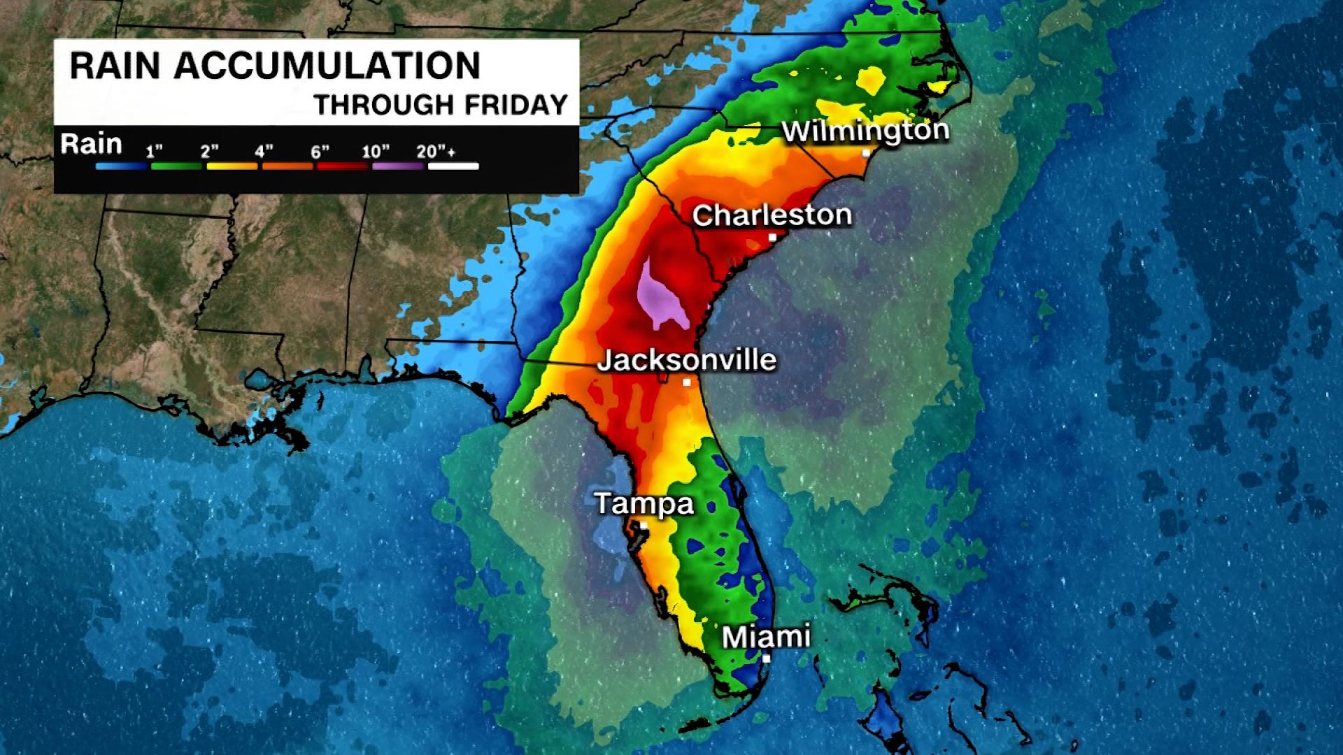
The Carolinas continue to see the heaviest rainfall, with a high risk of excessive rainfall – or a level 4 of 4 – remaining in place across parts of the states Wednesday overnight. Rainfall totals approaching 25 inches are possible across parts of South Carolina.

The high risk of excessive rain will shift north on Thursday, spreading from southern North Carolina to southwestern Virginia, with the highest rainfall expected between Charlotte and Raleigh, North Carolina, up toward Roanoke, Virginia.

Rainfall storm totals approaching 15 inches are possible for North Carolina and up to 10 inches are possible for Virginia. 

A tropical storm warning is in effect for north of the Savannah River to Surf City, North Carolina. A tropical storm watch is also in effect north of Surf City to Beaufort Inlet, North Carolina.

Flooding in Georgia county could get even worse if dam breaks

A dam about 50 miles northwest of Savannah, Georgia, is in danger of “imminent failure” as a result of Debby’s torrential rainfall, according to the National Weather Service in Charleston, South Carolina. 

A small portion of Georgia’s Bulloch County is under a flash flood warning through Thursday afternoon due to the risk of “life-threatening flash flooding” if the Cypress Lake Dam fails, according to the NWS.  

The area directly below the dam is at the greatest risk for this severe flooding.

Other portions of the county have already experienced serious flooding from Debby. The storm has dropped 8 to 12 inches of rain over the county since Sunday.

Crews carried out swift water rescues in at least one mobile home park in the county Wednesday, according to Georgia’s emergency management agency.  

Floodwaters raged on Tuesday afternoon as well, sending waves of water through forested areas.

Over 700 FEMA staff members deployed in the Southeast to assist with Tropical Storm Debby's efforts

Over 700 FEMA staff and federal partners have been deployed across the Southeast to assist with challenges brought on by Tropical Storm Debby, the agency shared in a news release.

“This slow-moving storm may bring life-threatening hazards including historic rainfall, leading to catastrophic flooding across Florida, Georgia, South Carolina and North Carolina through Friday,” the release says.

FEMA staff deployed in those states will “provide federal assistance to save lives, protect property and public health and safety.”

Search and rescue teams and swift water rescue assets are also on standby to assist as needed.

Here's when Debby could make landfall again

Tropical Storm Debby is still slowly meandering off the coast of South Carolina but the storm is forecast to push north and make landfall tonight.  

Debby’s center is less than 50 miles from the South Carolina coast and will likely come ashore between Charleston and Myrtle Beach, South Carolina. The storm is most likely to make landfall tonight, but it could end up being quite late at night if it keeps its current exceptionally slow pace.

Idalia was the last named storm to track across South Carolina. It was a tropical storm as it moved over the state in late August of 2023. The last storm to make landfall in South Carolina was Hurricane Ian. Ian was a Category 1 hurricane for its South Carolina landfall, which was the system’s third and final.

WATCH: 4 days of Debby in 40 seconds

Debby has been on a nearly four day-long journey since it first became a tropical storm Saturday evening thanks to its plodding forward speed.

For a time Tuesday evening, Debby was moving at just 3 mph, a typical walking speed for many people.

In the video below, which starts at 5 p.m. on Saturday when Debby became a tropical storm, watch such major milestones as:

  • Strengthening into a Category 1 hurricane (timestamp: 13 seconds)
  • Making landfall in Florida’s Big Bend region (timestamp: 17 seconds)
  • Returning to tropical-storm-strength (timestamp: 19 seconds)
  • Moving out over the Atlantic Ocean (timestamp: 31 seconds)
9acd3130-724e-4b1f-8f91-92c9ae29ebc9.mp4
00:40 • Source: cnn
00:40 • cnn

Satellite imagery courtesy of NOAA/CIRA.

More than a foot of rain has fallen in 3 states

A person looks at a flooded street in Cedar Key, Florida, on August 5. 

Rainfall totals from Debby total over a foot across three states, according to observation sites from the National Weather Service. Here are some of the highest totals for the period from 8 am Saturday, August 3 through 10 am Wednesday, August 7:

Florida

Lake City: 19.67”

Parrish: 18.86”

Sarasota: 17.78”

South Carolina

Summerville: 17.27”

Green Pond: 16.63”

Edisto Beach: 14.31”

Georgia

Rincon: 13.44”

Bellville: 13.04”

Newington: 12.28”

See a complete listing of rainfall at other locations here.

Heavy rain continues to impact the Southeast coast as Debby slowly moves north in the Atlantic Ocean off the coast of Charleston.

Flood warnings are in effect for portions of eastern Georgia, eastern South Carolina and eastern North Carolina. A flood watch remains in effect for portions of Georgia, South Carolina, North Carolina and Virginia.

As Debby’s second landfall nears, North Carolina governor advises “to be prepared for a deluge”

North Carolina Gov. Roy Cooper speaks about Tropical Storm Debby during a press conference on August 7.

As Tropical Storm Debby picks up strength and returns inland, the governor of North Carolina is warning residents to be prepared for major rainfall and flooding.

“All North Carolinians across our state need to be prepared for a deluge,” Gov. Roy Cooper said Wednesday. “More rain than most of us see in a month, or even several months.”

Emergency Management director William Ray said the state has already prepositioned 17 swift water rescue teams as a precaution. Cooper said the best thing people can do for their safety is to avoid walking or driving in flooded areas.

“Now is not the time to see if your car floats, because it doesn’t,” said Cooper.

Debby strengthens while churning just off the coast

Storm clouds are seen over Isle of Palms, South Carolina, on August 6.

Warm water just off the Atlantic Coast is allowing Tropical Storm Debby to strengthen. Debby now has sustained winds of 60 mph, according to the National Hurricane Center. That’s an increase of 15 mph from earlier this morning.

The storm is moving quite slowly to the northeast at just 5 mph. It’ll make a slow turn to the north later today and make landfall on the South Carolina coast between Charleston and Myrtle Beach tonight or early Thursday morning.

Some additional strengthening is possible before Debby makes landfall, but the storm’s center is still struggling with some dry air which could limit its potential.

Debby is still a rather robust tropical storm and will generate dangerous storm surge for the coasts of the Carolinas up to 3 feet above normal high tide through landfall. Additional rainfall will drench the Southeast through at least Thursday. 

President Biden approves disaster declaration for North Carolina

President Joe Biden speaks at the White House on August 1, in Washington, DC. 

President Joe Biden approved an emergency disaster declaration for North Carolina as Tropical Storm Debby lashes parts of the state.

The declaration unlocks federal funding assistance to supplement state and local response efforts to Debby.

It authorizes the Federal Emergency Management Agency to “coordinate all disaster relief efforts which have the purpose of alleviating the hardship and suffering caused by the emergency on the local population,” according to a news release from the White House.

Biden already approved declarations for Florida, Georgia and South Carolina due to the storm.

Ocean Isle Beach issues voluntary evacuation order as Tropical Storm Debby threatens storm surge

Ocean Isle Beach, a seaside town on a barrier island in North Carolina, asked residents and visitors to leave Wednesday due to the threat of storm surge from Tropical Storm Debby.

Ocean Isle Beach in an area in coastal Brunswick County that is under a storm surge watch, with the potential for a surge of up to four feet.

Debby's river flooding could last into next week and delay recovery 

Debby’s deluge has pushed waterways in the Southeast to their limits. Several dozen river gauges from Florida through the Carolinas have reached or are expected to exceed moderate or major flood levels.  

Major river flooding, the highest possible level, is ongoing for at least seven locations across the Southeast Wednesday morning and could swell to at least 16 locations in the coming days.  

Rivers in major flood stage are capable of flooding structures and forcing evacuations and can even reach record high levels.

River flooding is different from flash flooding that is sometimes able to drain away quickly. It could take days and sometimes weeks for excess water in rivers to work its way downstream and empty into a larger body of water like the ocean.

And when waterways are this swollen, floodwaters covering other surfaces can’t easily drain away and remain stuck in place.  

Many waterways are swollen due to Debby's rainfall. Multiple rivers are in major flood stage (purple circles) or are forecast to reach major flood stage (purple squares). Reds indicate moderate flood stage and oranges are minor flood stage.

Any additional rainfall over the Southeast this week will also delay the recession of rivers and worsen any ongoing flooding. 

Heat alerts issued in parts of Florida still recovering from Debby

Parts of northern Florida are under heat alerts today as the region is still recovering from Debby, which made landfall in the state’s Big Bend Monday as a Category 1 hurricane.

High temperatures in northern Florida, including Panama City and Tallahassee, are expected to climb between 95 and 100 degrees, with heat indices between 105 and 110 degrees.

These temperatures are 5 to 10 degrees above average.

As the temperatures climb, more than 35,000 customers in Florida were still without power Wednesday morning, according to PowerOutage.us.

Charleston curfew lifted as Debby lingers offshore

People walk on a flooded street in Charleston, South Carolina, on August 6.

As Tropical Storm Debby churns in the Atlantic before making a turn back toward the U.S. coastline, the city of Charleston, South Carolina, is lifting its curfew.

“After assessing overnight conditions, officials have determined that it is safe to return to normal activities,” the city announced in a news release Wednesday morning.

Only one road in Charleston remained closed as of 7:30am Wednesday. The curfew began Monday night

The Charleston police and fire departments said they did not need to perform any rescues during the storm.

Why some hard-hit areas are getting a breather from Debby's worst rain

Areas hit hard by Debby’s torrential rainfall over the last few days are getting a breather thanks to an assist from dry air. 

Tropical cyclones like Debby rotate in a counterclockwise direction and pull in surrounding air from all directions to feed their circulation. Moist air helps cyclones sustain themselves by fueling thunderstorms and dry air limits storm development.  

Debby has been ingesting some drier air from the west and south and it has worked its way into the center. Dry air and stormy weather don’t mix, so Debby has a significant area near its center largely free of storms.  

This satellite image shows water vapor values in a layer of the atmosphere above the surface Wednesday morning. Areas of blue and grey indicate spots where air has plenty of moisture. Red and orange areas show where air is dry.

Here's what to expect from Debby today

The center of Tropical Storm Debby is located over the Atlantic, about 65 miles south-southeast of Charleston, South Carolina, according to the National Hurricane Center. The storm has strengthened some since moving over water Tuesday afternoon and its sustained winds are now 45 mph, up 5 mph from last night.  

Some slight strengthening is likely as Debby meanders just off the coast. The storm is still producing drenching rainfall, but its heaviest rain bands are located well away from its center.  

Coastal North Carolina is bearing the brunt of the storm’s rainfall this morning, but that could change this afternoon. Heavy storms could develop closer to Debby’s center and lay down more rain over already-waterlogged portions of South Carolina, raising the flood risk.

A level 4 of 4 high risk of flooding rainfall is in place for far northeastern South Carolina and southeastern North Carolina.  

Debby will start to move north later today and make landfall between Charleston and Myrtle Beach, South Carolina, overnight. Storm surge flooding up to 4 feet is possible along the coast of the Carolinas through landfall. Debby will also generate dangerous seas and rip currents along the East Coast.  

Mount Pleasant drainage systems are full as flooding from Debby persists, officials say

A street is flooded by Tropical Storm Debby on August 6, in Charleston, South Carolina.

Officials in Mount Pleasant, South Carolina, informed residents on Tuesday that flooding fueled by Tropical Storm Debby has persisted “because drainage systems are generally full.”

“There is nowhere for the water to drain” because “many ponds and the surrounding wetlands are at capacity,” the officials said.

“There is no immediate fix for this issue,” the town said. “Further investigation will be conducted once water levels lower, and we can get a better look at the system,” the message read. 

Mount Pleasant is a town in Charleston County, South Carolina.