What we're covering
• Crippling blow: A massive winter storm’s damaging ice has knocked out power to over 900,000 customers across the mid-Atlantic and South. The outages could last for days in hard-hit Nashville and beyond.
• Schools, travel shut down: Over 16,000 flights, an extraordinary amount, have been canceled during the storm as airports shut down. Schools in major cities across the US have canceled or moved classes to remote learning for Monday.
• Big Northeast snow: Heavy snow was falling in the Northeast’s highly populous Interstate-95 corridor with some cities, including Boston, expecting their most snow in years.
• Deadly, record cold: At least six people have died in the coldest temperatures of winter. The cold will linger into the week, raising fears for those without shelter or power for days.
Latest videos


Power lines accumulate ice in Rolling Fork, MS.

A water main break in Pineville, North Carolina, just south of Charlotte, in freezing temperatures shut down portion of highway after it turned everything to ice, according to CNN affiliate WSOC.
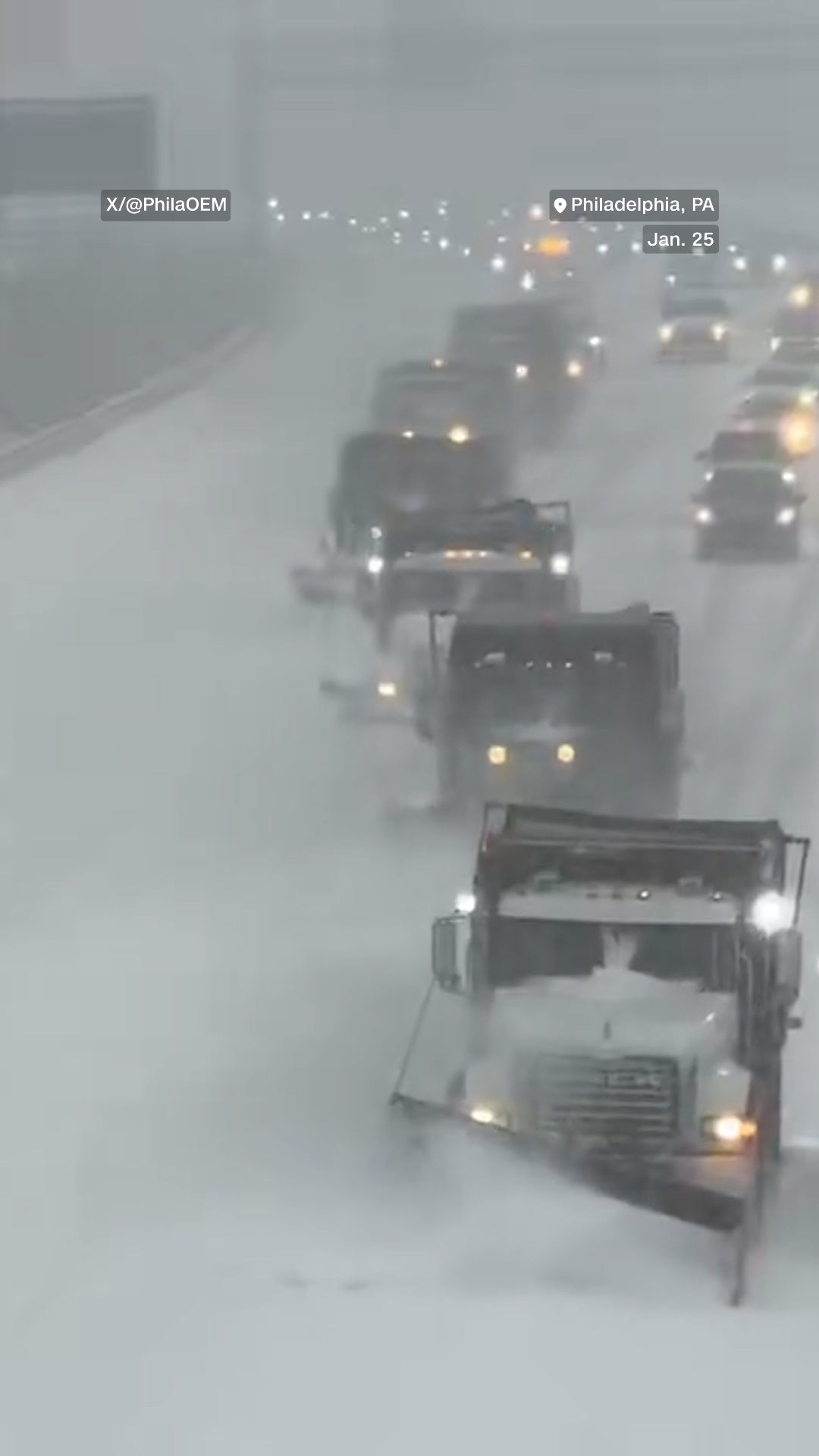
This is satisfying to watch. Six staggered snow plows clear this road in the Philadelphia area for a procession of vehicles that follow, almost like a NASCAR pace car.
A couple of inches of snow have fallen in Philadelphia so far.

Meteorologist Ryan Knapp caught thundersleet on camera outside of the NWS office in Shreveport, LA.

Intense, fluffy snow turned parts of New Jersey into a snow globe, with up to 4 inches already on the ground in portions of the state’s shore region by mid-morning.

Reporting from Louisville, Kentucky, Meteorologist Derek Van Dam explains how hopes for a record-shattering snowfall have been largely dashed thanks to sleet.

This car in Mississippi is completely covered in a layer of ice on Sunday morning.

Video posted by a power provider in Texas shows exactly the phenomenon we told you about yesterday: galloping power lines.

This Washington D.C. resident brought out the skis to enjoy the snow.

More than 100 flights cancelled as of 8 a.m. on Sunday at Cincinnati/Northern Kentucky International Airport.
Watch: Water main break in cold encases everything in ice, closes road south of Charlotte
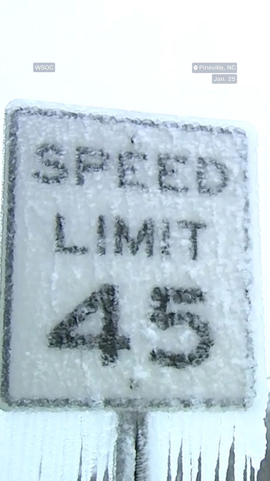
A water main break in Pineville, North Carolina, just south of Charlotte, in freezing temperatures shut down portion of highway after it turned everything to ice, according to CNN affiliate WSOC.
The Pineville Police Department in North Carolina says a section of Highway 51, was shut down Sunday morning after the pipe broke. It has since reopened, WSOC reported.
Temperatures dropped to around 18 degrees overnight in the Charlotte area, which is about 15 degrees colder than a normal late January night.
The city is still only hovering around 20 degrees early Sunday afternoon.
Watch: Oklahoma City house "engulfed" by flames and smoke in frigid conditions

Firefighters battle house fire amid freezing temperatures and surrounded by snow in Oklahoma City.
A house in southeast Oklahoma City was “almost totally engulfed” by flames and smoke and surrounded by snow from the storm on Sunday, according to CNN affiliate KOCO News 5.
Firefighters said occupants had reported a fire in their garage and were able to escape. No injuries were reported as of 11 am CT, KOCO News 5 reported.
The Oklahoma City fire department was on the scene in challenging conditions, working to get water to douse the flames. It’s currently 8 degrees in the area, and the high temperature for today is only 13 degrees. Winds are blowing at 10-15 miles per hour with gusts up to 25 mph.
Those winds could hinder fire crews but are also dropping the wind chill into the single digits below zero. Wind chills could get to -11 or -12 around midnight.
CNN has reached out to the Oklahoma City fire department on whether the fire was related to the winter storm.
NYC Mayor says stay home and watch "horrible reality TV"

New York City Mayor Zohran Mamdani encouraged people to stay indoors and watch “horrible reality TV” as heavy snow continues to blanket the city.
“We are frankly seeing too many New Yorkers still out on the roads. That’s actually impeding the ability for sanitation to meet this moment,” Mamdani said told CNN, standing near the frozen Harlem Meer in Central Park.
Snow is falling steadily, covering streets, sidewalks and cars in powdery frost. It is also bitterly cold and windy, making conditions increasingly dangerous if there is prolonged exposure.
“This is still going to be the coldest period that New Yorkers have seen for the last 8 years,” Mamdani said.
There are thousands of sanitation workers out on city streets and plows have started to clear roadways. The city has also opened 10 warming centers across the five boroughs for anyone in need of shelter and heated space.

Mamdani said the city’s sanitation workforce has been increased from 2,000 workers to 2,500 working 12-hour shifts.
“These are those people who’ll be doing the work in the moment and the ones who’ll be cleaning up after the fact,” Mamdani said. “Stay home, find some horrible reality TV – today’s the day.”
Photos: Snow and ice blanket the eastern US
The massive winter storm has covered more than 1,800 miles of the US from the Rockies to the East Coast in snow and ice since Friday.
See more photos from the storm.


Major universities cancel classes as storm hits campuses
From New England to the deep South, major universities are announcing plans to close buildings and cancel classes on Monday as snow and dangerously cold temperatures hit campuses.
The spring semester was supposed to begin Monday at the University of Maryland, but school officials are asking students who haven’t returned to campus yet to stay away for a few days until the snow is cleared. Classes on the College Park campus are canceled Monday.
Boston University shut down all three of its campuses starting at noon on Sunday as the school braces for 12 to 18 inches to blanket the area, and it will remain closed on Monday. Nearby Tufts University is following the same plan. Brown University in Providence, Rhode Island, also canceled in-person classes on Monday.
Meanwhile, hundreds of miles to the south, University of Georgia and University of North Georgia have closed and canceled Monday classes. So has Miami University of Ohio.
Along the East Coast, schools say they are continuing to monitor the storm and taking precautions. Middle Tennessee State University, for example, is shifting classes to remote only on Monday and Tuesday.
Tornado watch issued for parts of the South
A tornado watch has been issued covering portions of the Florida Panhandle, southeast Alabama and southwest Georgia. The watch is in effect until 7 p.m. ET Sunday and includes Panama City, Florida; Montgomery, Alabama; and Albany, Georgia.
A cold front associated with the massive winter storm is draped across Alabama and is triggering a line of thunderstorms that’s expected to strengthen through the afternoon. Extreme temperature differences in the state ranging from the 70’s in the south to mid 30’s in the north create a ripe environment for strong storms.
Wind could worsen ice impacts even after the storm leaves
Ice coating trees and power lines in the South is damaging on it own, but in some areas wind could amplify the impacts even after the storm is over.
Wind gusts in the wake of the ice storm could be over 20 mph at times through Monday. That includes ice-affected areas in the lower-Mississippi and Tennessee valleys and from northeast Georgia to the Carolinas and Virginia.
Winds of that strength add even more force to power lines and tree branches that are already weighed down by ice, making for a one-two punch that can worsen the destruction.
Snow is changing over to sleet in Philadelphia
The line that’s separating fluffy snow from an icy wintry mix continues to creep into the Northeast late this morning as the massive winter storm trudges along.
Philadelphia is the latest major city to see their snow globe snow turn to something much messier. Weather observation stations there are now picking up ice pellets — sleet — mixing in with snow.
CNN’s Danny Freeman is in downtown Philadelphia and caught the early sounds of that icy sleet mixing in.

Public transit services suspended in Charlotte until Monday
The Charlotte Area Transit System has suspended all services until Monday due to “hazardous winter weather conditions,” the agency said on its webpage.
CATS manages all the public light rail, bus, street car and transit services for individuals with disabilities in the Charlotte area.
The agency says it expects all services except express buses to resume Monday at 10 a.m. local time.
Widespread Nashville power outage could last for "days"

A widespread power outage in the Nashville metropolitan area could last for days, according to the electric utility Nashville Electrical Service.
“This will be a longer outage which could span over days or longer,” NES said in a Sunday morning post on X. Ice has weighed down trees, causing many to snap and fall on power lines.
The utility said nearly 200,000 of its customers are currently without power and there have been “at least 7 broken poles” reported across its service area. NES said it has crews out working on restoring power in continuous shifts.
As of 11:30am ET, Tennessee has more power outages than any other state, with over 290,000 reported, according to poweroutage.us — the bulk of which are in the Nashville metropolitan area.
Tennessee city says 911 is "inundated" with downed power line calls
Just 15 miles north of Nashville, multiple roads in the city of Goodlettsville, Tennessee, are closed as ice downed trees and power lines.
The city said 911 is “inundated with calls regarding downed power lines” Sunday morning, and asked residents to only call for downed lines that are actively causing emergencies due to concerns that “medical or critical emergencies are not able to get through.”
Goodlettsville is within both Davidson and Sumner counties. More than 90% of customers in Davidson County — where most of the city’s residents live — are currently without power, according to PowerOutage.us. About 20% are without power in Sumner County.
Dramatic temperature differences are in place in the South

There’s currently nearly a 60-degree difference in temperatures between parts of the Gulf Coast and areas only a few hundred miles farther north.
For example: Mobile, Alabama, is currently a balmy 73 degrees while Memphis, Tennessee, is shivering at 16 degrees. A little over 300 miles separates the two southern cities.
At the same time, parts of South Florida were sitting at a toasty 82 degrees.
Warm air from the Gulf is keeping temperatures high in Florida and Alabama while the rest of the region is being blasted by Arctic air.
Two storm-related deaths reported in Louisiana
Two men have died from hypothermia in Louisiana from this weekend’s storm, according to that state’s Department of Health.
The two men, whose ages are unknown, died in Caddo Parish, located in the northwest corner of the state. Both deaths were confirmed by the parish coroner as storm-related, according to the Louisiana Department of Health, which said it would release no further information about the deaths.
The health department urged residents to seek shelter in warming centers around the state, a list of which can be found here.
Schools canceling class or moving to snow days due to storm
Here’s a list of some of the largest public school systems that have canceled class or moved to remote learning due to the winter storm.
New York City: School buildings are closed and classes will be going to remote learning on Monday, the city said.
Chicago: Public schools were closed on Friday due to frigid temperatures but are expected to reopen on Monday.
Houston: All schools and facilities in the Houston Independent School District will be closed Monday, according to an update on the district’s website.
Atlanta: Gwinnett County, Fulton County and City Schools of Decatur will hold classes remotely, and DeKalb County will cancel classes Monday, according to updates on their sites.
Dallas: The Dallas independent school district will be closed Monday, according to their website.
Charlotte: Public schools in North Carolina’s largest city will be closed Monday.
Philadelphia: All Philadelphia public schools will be closed Monday, the district announced on their website.
Boston: Boston public schools will be closed Monday, according to their website.
Memphis: All Memphis-Shelby County Schools are closed Monday due to “hazardous conditions,” according to their website.
Still to decide: Large public school systems in the Washington, DC, Maryland and Virginia area have yet to announce their decisions on cancellations.
Snow arrives in Boston, where totals are expected to be highest in years
Light snow developed in Boston within the past hour, but there’s plenty more to come.
Snow could fall at rates of 1 to 2 inches per hour this afternoon and evening, and when all is said done on Monday, storm totals could reach up to 2 feet.
The last time about that much snow fell was between January 28 and 29, 2022, when 23.8 inches buried Beantown. January 2015 is the last time a storm dropped enough snow to break through the 2-foot threshold.
Boston’s biggest snowstorm was 27.6 inches in February 2003. At least 24.9 inches would need to fall through tomorrow for this one to climb into Boston’s top five heaviest storms.
Snow is super fluffy in New Jersey

Snow is coming down hard in northern New Jersey this morning, but everything that’s piled up is very fluffy, dry snow. The powdery snow is happening because it’s so cold outside (currently, the air temperature is in the single digits).
When it’s this cold on the ground and in the air above, snowflakes grow slowly and stay solo instead of clumping together or melting as they fall to the ground. The resulting snow is so light that just a bit of wind can blow it around and limit visibility, which is happening this morning.
It’s also not the best snowball snow, since it’s so dry and crumbly, as you can see in the video above.
This fluffy snow will be a thing of the past once snow mixes with icy sleet and freezing rain later today.
Worst ice impacts still to come for the Southeast and Virginia
Freezing rain has already impacted northeast Georgia and the Carolinas, but the worst is coming later today, and it’s expected to spread into parts of Virginia, too.
Most ice reports so far have been below a quarter-inch from northeast Georgia into the Carolinas, which isn’t usually damaging. However, the ice build up is expected to worsen significantly in those areas beginning this afternoon.
The concern is that heavy rain falling over Mississippi and Alabama right now will cause ice amounts to grow fast once the rain reaches cold air east of the Appalachians. That will include areas near the Interstate 85 corridor from northeast Georgia to Greenville, South Carolina, Charlotte and Greensboro, North Carolina, and Richmond, Virginia.
Expect reports of power outages and tree damage to increase dramatically by this evening in these areas.
All flights canceled on Sunday at Reagan National Airport

All flights into and out of Ronald Reagan Washington National Airport on Sunday have been canceled due to the winter storm thrashing the area, the airport posted to its social media pages.
More than 400 flights were due to arrive at Reagan today, and another 420 were scheduled for departures, FlightAware data shows.
The airport itself is still open for stranded passengers, with TSA screening for employees and ticketed passengers, and limited concessions available in terminals.
Trump energy secretary issues emergency orders to keep power plants running
Energy Secretary Chris Wright has issued emergency orders to Texas and mid-Atlantic grid operators to bypass pollution limits to keep power plants and backup power systems running throughout the winter storm.
It’s an attempt to keep the lights on, as electrical outages mount around the country. However, many of the outages so far have come from ice-laden trees falling on power lines.
Texas has over 130,000 power outages, according to tracking website PowerOutage.com. The mid-Atlantic region doesn’t have outages yet; the storm has been moving into the region on Sunday.
Wright on Friday asked grid operators to make backup generation available from facilities like data centers. It’s a somewhat untested plan. Although some data centers have their own backup power supplies, they don’t typically distribute power to the grid, and it wasn’t immediately clear how they would do so in an emergency weather situation.