

A powerful storm started drenching Florida Saturday and is expected to strengthen as it tracks up the East Coast through the weekend, unleashing heavy rainfall, gusty winds and coastal hazards along the way.
A blockbuster snowstorm is not expected, despite the time of year, but this very warm, wet and blustery storm could still snarl early holiday travel and knock out power.
Computer forecasting models show the storm’s track hugging the Atlantic coast on Sunday and Monday after moving through Florida on Saturday.
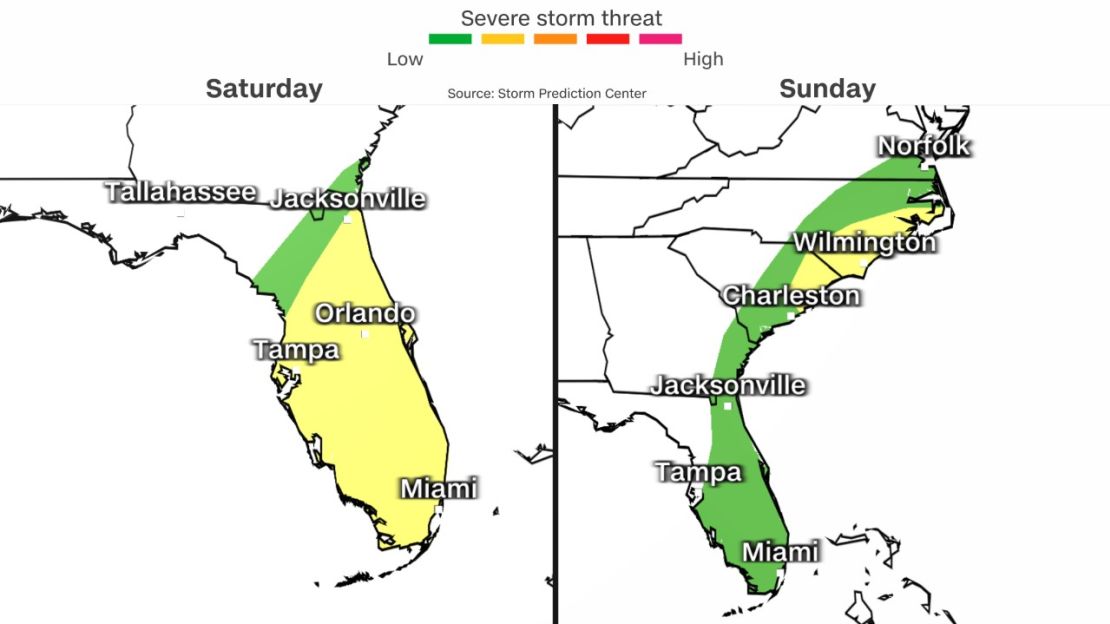
Across most of Florida, some 17 million people are under threat of severe weather Saturday, in large cities including Jacksonville, Tampa and Orlando. It rained across most of the state by Saturday evening as wet weather began spreading into southern Georgia. Most of the threat is from possible tornadoes and strong winds. The peak risk level is 2 out of 5.
Millions more face similar threats Sunday into the Carolinas, including Wilmington in North Carolina and Myrtle Beach in South Carolina.
Here’s what to expect each day:
Saturday: Florida takes a blow
By Saturday night, heavy rainfall is forecast to drench almost the entire state of Florida and spread into the Southeast.
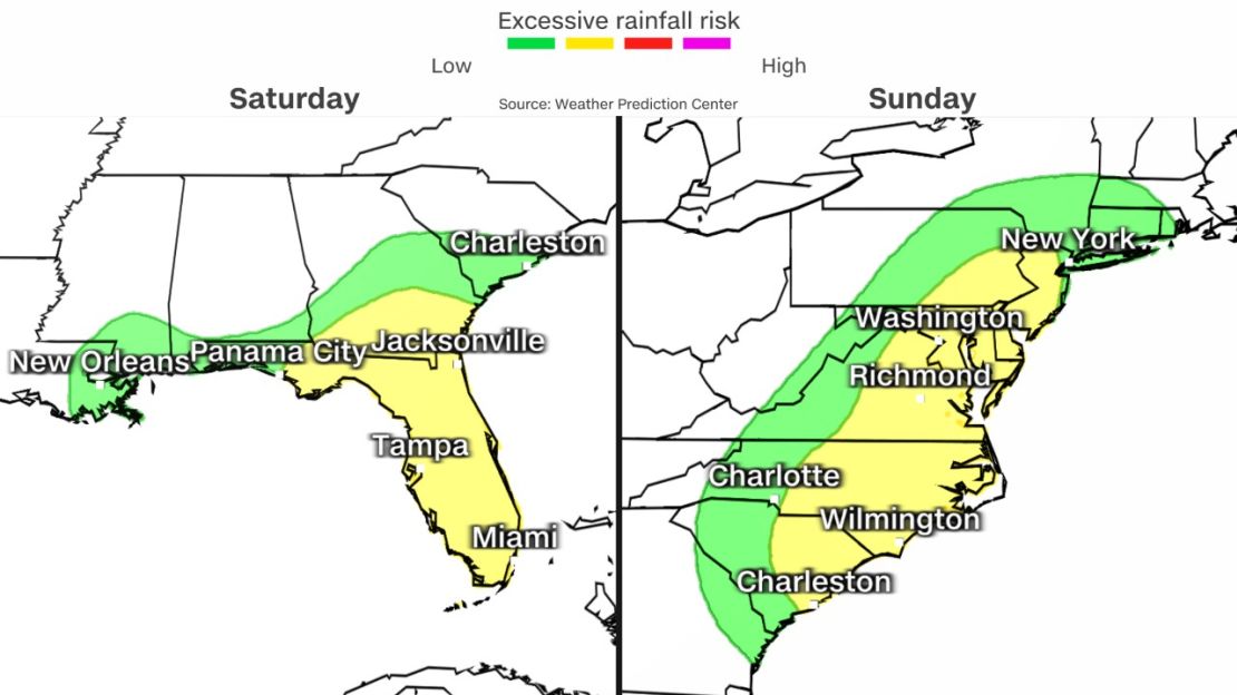
A slight risk of excessive rainfall – or Level 2 out of 4 – is forecast for a majority of Florida and far southern Georgia on Saturday. Rain could fall heavily enough on Saturday to trigger flash flooding and may cause streams and rivers to rise.
South Florida is particularly vulnerable to flash flooding following multiple rounds of soaking rainfall this week, but it can occur anywhere there is a persistent deluge.
The heavy rain will also be accompanied by gusty winds, with the strongest winds arriving Saturday evening as the center of the storm closes in on the Florida coast. Widespread wind gusts of 30 to 40 mph are possible across much of the Florida Peninsula through Saturday night.
Stronger gusts are likely at the coast, but will depend on the exact track the storm takes as it approaches the Florida coast on Saturday, which is still unclear.
A slight deviation in the storm’s path north or south as it moves toward the Florida Peninsula will shift where the strongest winds occur and will make a significant difference in the location and extent of coastal flooding.
Damaging wind gusts and a few tornadoes are possible late Saturday and overnight across the Florida Peninsula. A Level 2 out of 5 risk for severe thunderstorms includes Tampa and Miami.
Sunday: Rain and wind spread up the East Coast
On Sunday, the storm will track northeast out of Florida and hug the East Coast, expanding its impacts from Georgia to portions of the Northeast.
A slight risk of excessive rainfall – or Level 2 out of 4 – is forecast Sunday from parts of South Carolina north into portions of Pennsylvania and New Jersey.
The heaviest rain during the day will target the Carolinas and coastal Georgia as the storm strengthens and begins to accelerate up the coast. Rain will begin across the mid-Atlantic and parts of the Northeast by Sunday afternoon, but the heaviest will arrive late Sunday and Sunday night.
Flood watches cover areas that include more than 60 million people, including in Miami, Jacksonville, Washington, DC, Philadelphia and New York.
Rainfall rates are expected to be low enough to limit flash flooding, but hours of steady rainfall will lead to the potential of flooding in urban areas as well as locations with poor drainage.
Smaller rivers and streams will also be prone to minor to moderate levels of flooding, according to the National Weather Service.
Strong wind gusts will slam coastal areas from the Southeast through the mid-Atlantic on Sunday and the coastal Northeast on Sunday night. Frequent gusts of 40 to 50 mph are possible for much of the coast while inland areas will be breezy, but spared the worst winds.
The combination of strong winds and heavy rainfall will likely slow travel across a significant portion of the region, especially the busy I-95 corridor. Gusty winds and reduced visibilities may delay some air travel.
Monday: Storm reaches peak strength in Northeast
The storm will reach its peak strength on Monday, just in time to deliver disruption to a large portion of the Northeast. It is forecast to track very close to the Northeast coast during this time but could also move more away from the coast.
Regardless of its exact track, the storm will bring nor’easter-like impacts to the coastal Northeast on Monday – minus the snow.
The heaviest rain and strongest winds will likely center on New England on Monday, but wet and breezy conditions will be the norm for a majority of the Northeast.
Wind gusts up to 60 mph are possible along the New England coast starting early Monday morning and along coastal Maine by Monday afternoon. Winds this strong mean power outages are possible in the region, especially when coupled with heavy rainfall that soaks soils and makes trees easier to topple.
Wind-driven coastal flooding is also possible and could become significant if the timing aligns with high tides.

