
A potent storm will track from the Gulf of Mexico into Florida and move north up the East Coast this weekend, bringing with it the chance of flooding rainfall and gusty winds for much of the eastern United States.
The storm’s exact track and strength as it moves through Florida and into the Southeast Saturday are still unclear and will determine the storm’s severity in spots all the way to New England into next week.
Two scenarios are possible; one that pulls the storm toward the Florida Panhandle and then more inland, and one that brings it into the Florida Peninsula and then closer to the coast.
For now, the threat of flooding rain and gusty winds is most pronounced in Florida, parts of the Gulf Coast and the Southeast on Saturday. Additional threats may also develop, including severe thunderstorms and coastal hazards like flooding and rip currents.
In preparation for the severe weather, Florida Governor Ron DeSantis activated the state guard Friday, his office said in a news release.
DeSantis also directed the state’s division of emergency management to prepare equipment needed to help residents who may experience flooding, strong wind gusts and tornadoes, the release said.
The forecast should become clearer by Friday, but for now, here’s what each scenario could unleash this weekend.
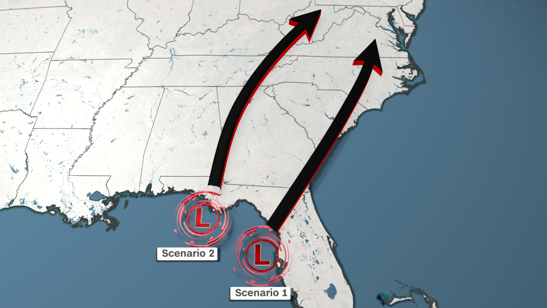
Scenario 1: Florida Peninsula, then more coastal
Heavy rain will begin Saturday and continue through Saturday night across much of Florida in both scenarios. But in scenario one, the track of the storm brings most of the flooding rain straight to the state’s peninsula, reducing the risk in the panhandle.
A slight risk, or Level 2 of 4, of excessive rainfall is forecast for the Florida Peninsula on Saturday, while a marginal risk, or Level 1 of 4, is forecast for the Florida Panhandle, according to the Weather Prediction Center.
Rain could fall heavily enough on Saturday to trigger flash flooding, especially across South Florida where it’ll continue to be quite soggy through the week’s end.
The heavy rain will also be accompanied by gusty winds, with the strongest winds arriving Saturday evening as the center of the storm closes in on the Florida coast. Widespread wind gusts of 30 to 40 mph are possible across much of the Florida Peninsula through Saturday night in this scenario, with stronger gusts possible at the coast.
Strong wind gusts will also push water ashore and produce coastal flooding, especially along Florida’s Gulf Coast. Dangerous surf and rip currents are also likely through the weekend across the eastern Gulf of Mexico, Florida Keys and the southeast Atlantic coast.
As if drenching rainfall, strong winds and coastal flooding weren’t enough, a few severe thunderstorms may rumble to life late Saturday across the Florida Peninsula. These storms may produce tornadoes, but it’s not a guarantee given the complexity of the forecast.
On Sunday, the storm tracks northeast and moves out of Florida to hug the Southeast coast, which could mean the heaviest rain and strongest wind sets up closer to the coast.
The storm will spread rain across more of the Southeast by late Saturday and rain will become drenching by Sunday. Enough rain could fall to cause flash flooding in Georgia and the Carolinas.
The storm could continue to move along the coast into the Northeast, which typically means gusty, stormy weather for the region.
Scenario 2: Florida Panhandle, then more inland
This scenario is slightly less likely than the first scenario, but some computer forecast models say it’s still a possibility.
In it, the Gulf storm makes a beeline for the Florida Panhandle on Saturday, unloading the worst of its rain there. This track also places more of southern Georgia and southern Alabama in the heaviest rain threat.
This scenario’s track, which is more western, moves the location of Saturday’s strongest winds into more of the Florida Panhandle. Breezy conditions are still likely across the peninsula in this scenario, but gusts may not be as strong or as frequent.

Coastal impacts could expand along more of Florida’s Gulf Coast if this scenario were to play out.
A storm closer to the Panhandle could drive winds directly into the coast from South Florida into the state’s Big Bend region and lead to expansive coastal flooding. Rough seas and dangerous rip currents are also likely in this scenario.
The storm may then track northward along the spine of the Appalachians Saturday night through Sunday and spread heavy rain much farther inland than the first scenario. Rain is still likely across much of the Carolinas, but it may be less intense.
Monday will be a sloppy day with plenty of rain across much of the mid-Atlantic and Northeast as the storm tracks north, regardless of its final track.

