The 2023 Atlantic hurricane season ends on Thursday as one of the busiest on record, with a twist: Most of its storms veered into the middle of the Atlantic Ocean.
But with El Niño expected to end next year and global temperatures on the rise, forecasters say there’s “high potential” for an even more active hurricane season in 2024 and uncertainty around what that could mean for the United States.
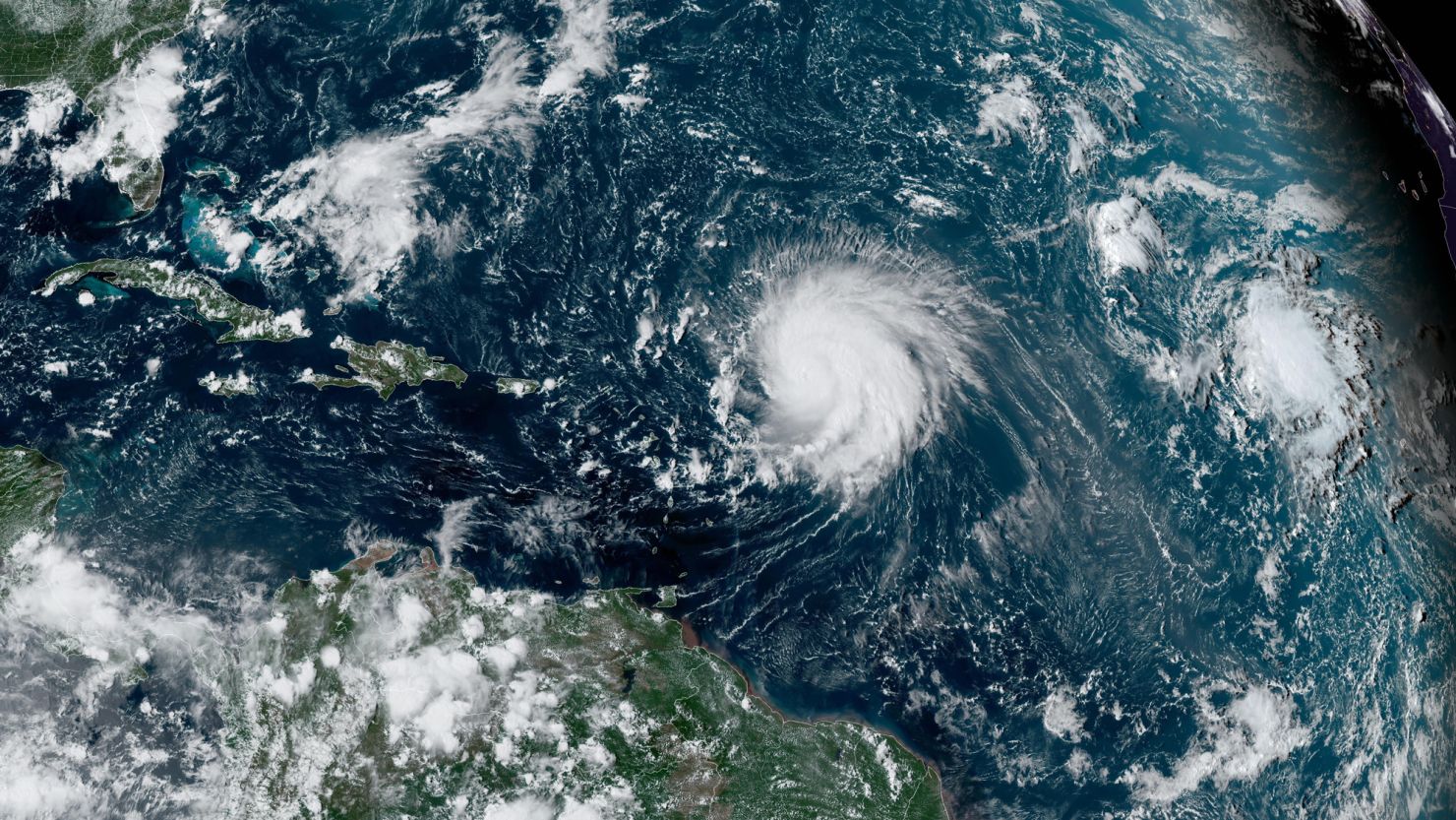
Record-high ocean temperatures this season ushered in above-average tropical activity and neutralized the effectiveness of a strengthening El Niño, which typically inhibits storm development in the Atlantic by ripping them apart with hostile upper level winds.
By season’s end, 20 named storms, including seven hurricanes, came to life. Fortunately, only a fraction of these storms unleashed their fury on land.
Three Atlantic storms made landfall in the US: Harold, Idalia and Ophelia. Idalia was the only hurricane to hit the US this year when it slammed Florida as a powerful Category 3 hurricane in August, becoming the strongest storm to strike the state’s Big Bend region in more than 125 years.
The season’s 20 named storms were the fourth-most in a single year since 1950, according to NOAA. Only the hyperactive hurricane seasons of 2020, 2005 and 2021 had more.
Fourteen named storms develop during an average hurricane season in the Atlantic, but when El Niño is strong, the number of named storms is typically lower.
“The Atlantic basin produced the most named storms of any El Niño influenced year in the modern record,” Matthew Rosencrans, lead hurricane forecaster at NOAA’s Climate Prediction Center said in a news release.
Extremely warm ocean water also provided fuel for rapid intensification, causing a few storms – including Idalia and Hurricane Lee – to explode in strength. Lee maxed out as a rare Category 5 hurricane in the open Atlantic after its winds increased a staggering 85 mph in 24 hours.
Since the season was able to achieve so much tropical activity despite El Niño’s best efforts to stifle development, it’s remarkable that most of these storms did not impact land.
When storms develop in the tropical Atlantic, it’s the strength of the Azores High – a large, semi-permanent area of high pressure in the Atlantic off the northwestern coast of Africa – that acts like a force field, either pushing storms west toward the US or pulling them away toward the open Atlantic.
“When you have a really strong high, storms tend to just keep trekking to the west or to the west-northwest into the Caribbean or through the Bahamas and into Florida or up the East Coast,” Brian McNoldy, a senior research scientist at the University of Miami, told CNN.
But that wasn’t the case this season, since the high pressure was quite weak due in part to record-high ocean temperatures, according to McNoldy. So, many of the storms that developed out in the tropical Atlantic followed the weakness in the high pressure and turned north, then moved northeast and deeper out to sea.
“Just that one ingredient (the record-warm water) helped to make for a more active hurricane season, but it also helped to keep that activity away from land,” McNoldy explained.
El Niño could disappear next hurricane season
Hurricane experts say it’s too early to know whether so many storms will dodge land next Atlantic hurricane season, but at least one thing is clear for the 2024 season: El Niño isn’t sticking around.
“The confidence that we’re not going to have El Niño next hurricane season is pretty high, especially by August or September,” Phil Klotzbach, a research scientist at Colorado State University, told CNN.

A strong El Niño is unable to maintain its strength indefinitely and typically transitions to a neutral pattern or even a weak La Niña in the following year. Without El Niño in place to help limit storms, the template for next hurricane season could look quite different.
“With El Niño going away, certainly the potential is there for an above normal season – a relatively high potential,” Klotzbach said. “If we hadn’t had an El Niño (this year) we certainly could have seen a season on par with 2020 or 2005.”
But El Niño isn’t the only factor that could shift next year.
“The part we don’t really have a clue about yet is how warm the Atlantic will be,” McNoldy said.
Even if the fate of next year’s ocean temperatures remains uncertain, global temperatures are still rising because of human-caused climate change and will continue to put oceans at risk of warming.
Given the uncertainty in ocean temperatures next year, the ultimate strength of the Azores High and its ability to steer storms toward the US is also a “huge question mark,” according to Klotzbach.
“We’ll see what transpires next year, but certainly, it has the potential to be quite interesting,” Klotzbach said.
Rapid intensification dominates East Pacific season
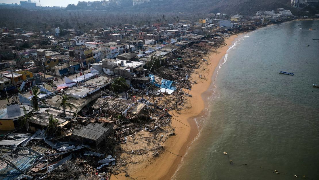
The 2023 Eastern Pacific hurricane season also ends on Thursday and had several impactful storms, including two of the strongest hurricanes to make landfall on the Pacific coast of Mexico.
The season’s 17 named storms were busier than average. Of those storms, 10 became hurricanes and several experienced explosive rapid intensification.
Hurricane Otis was the most extreme example. Otis strengthened by an astounding 115 mph in 24 hours all the way up to its devastating Category 5 hurricane landfall in Acapulco, Mexico.
Otis was the strongest Pacific storm to ever strike Mexico and came just two weeks after Category 4 Hurricane Lidia made landfall just south of Puerto Vallarta as another one of Pacific Mexico’s strongest storms.
Hurricane Hilary went through a period of rapid intensification which helped the storm maintain enough strength to track across California as a tropical storm – the state’s first since 1997. Hilary unloaded a deluge of rainfall that broke records for tropical rainfall in a few states and caused extreme flooding that lingered for months in one of the driest places on Earth.
Earlier in the season, Hurricane Dora underwent rapid intensification as it tracked south of Hawaii and contributed to a strong wind event that helped spark the catastrophic Lahaina Fire, the deadliest fire on US soil in more than 100 years.

