Multiple tornadoes reported in Florida Panhandle, including near Panama City

January 9, 2024 - Winter storm slams central and eastern US

By Antoinette Radford, Adrienne Vogt, Aditi Sangal, Maureen Chowdhury and Emma Tucker, CNN

Updated 12:00 a.m. ET, January 10, 2024
13 Posts
Sort byDropdown arrow
9:26 a.m. ET, January 9, 2024

Multiple tornadoes reported in Florida Panhandle, including near Panama City

From CNN Meteorologists Mary Gilbert and Brandon Miller

Tornado damage is seen a screengrab taken from video shared by storm chaser Jay Lesyk. Lesyk said he was in Grand Lagoon, Florida when he observed a tornado hit the area early Tuesday morning.
Tornado damage is seen a screengrab taken from video shared by storm chaser Jay Lesyk. Lesyk said he was in Grand Lagoon, Florida when he observed a tornado hit the area early Tuesday morning. Jay Lesyk

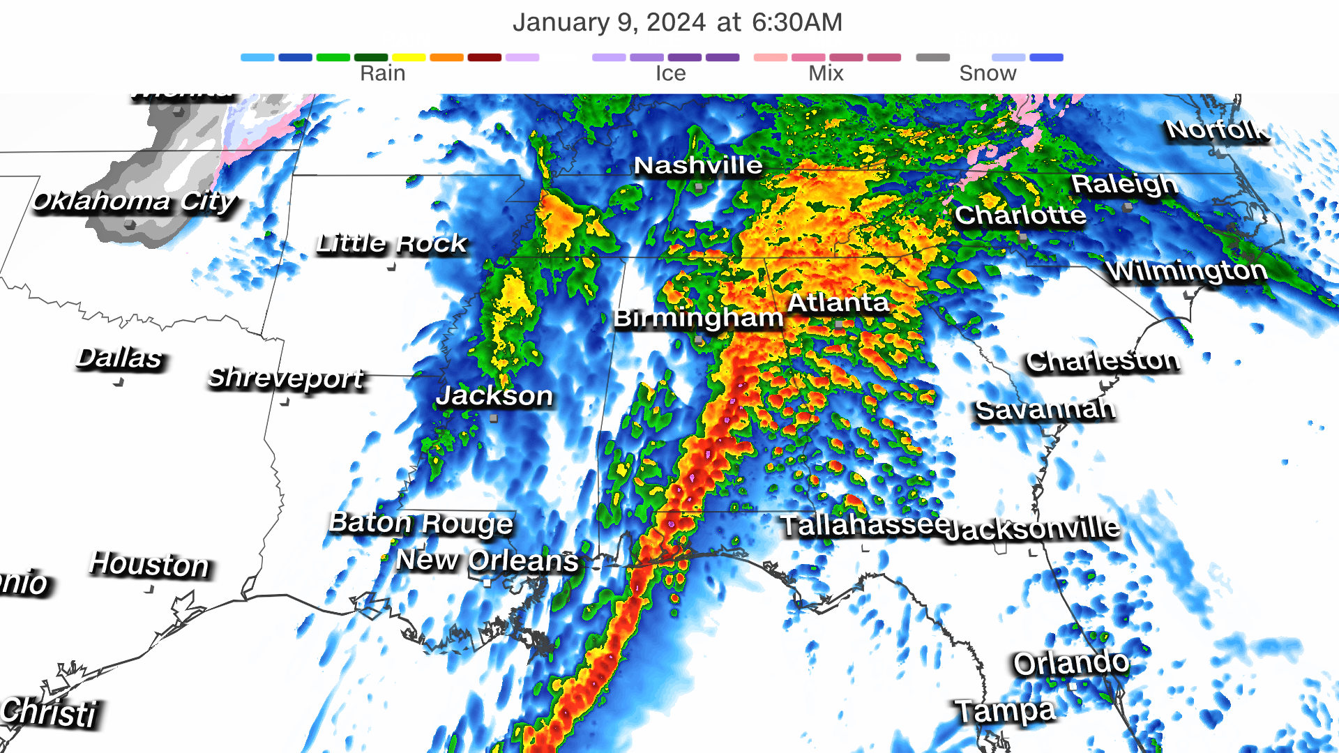
Several tornadoes have been reported this morning in the Florida Panhandle as a strong line of thunderstorms moves through the area.

National Weather Service meteorologists reported a “large and extremely dangerous tornado” near Panama City just after 5:30 a.m. CT (6:30 a.m. ET).

"This is a PARTICULARLY DANGEROUS SITUATION," the weather service added.

The tornado continued to track northeast, passing near Lynn Haven, Florida, shortly before 7 a.m. ET.

"To repeat, a tornado is on the ground. TAKE COVER NOW!" the weather service warned.

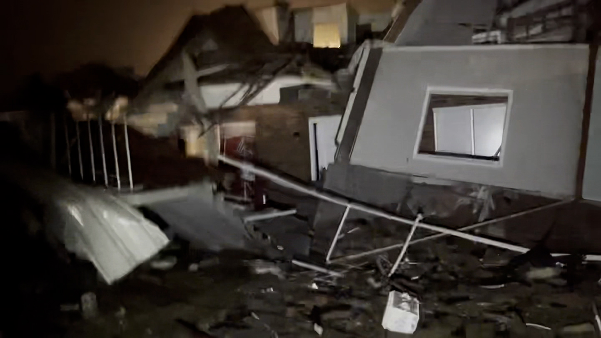
Social media videos from the area at that time appear to show a strong waterspout moving onshore as well as damage after the storm passed.

NWS meteorologists continue to track the storm, which is confirmed to still be producing a dangerous tornado near the town of Marianna, passing Interstate 10.

At least five tornadoes have been reported in the last couple of hours, according to data from the Storm Prediction Center.

7:56 a.m. ET, January 9, 2024

Tornado watch issued for portions of Florida, Alabama and Georgia

From CNN's Monica Garrett

A new tornado watch is in effect until 2 p.m. ET for portions of southeastern Alabama, the eastern Florida Panhandle to northern Florida, and southern Georgia, according to the Storm Prediction Center.

This watch covers over 2 million people and includes Tallahassee, Panama City and Lake City in Florida, Dothan in Alabama, and Albany and Valdosta in Georgia.

A strong line of storms, with potentially tornadic circulations and damaging straight line winds up to 75 mph, will sweep eastward across the watch area through the remainder of the morning into early afternoon.

“A few supercells also are possible ahead of the line with a threat for tornadoes (some strong), severe gusts and isolated hail,” the SPC said.

Over 40 million people across the Southeast are at risk of severe storms today. A Level 3 of 5 risk of severe storms covers much of Florida, Georgia and the Carolinas on Tuesday, where tornadoes and damaging winds are possible.

7:17 a.m. ET, January 9, 2024

Power outages across southern and central US affect more than 240,000 customers

High winds continue to impact much of the central and southern US, which has increased power outages to over 244,000 customers, according to poweroutage.us

Here the states with the highest power outages as of 7:15 a.m. ET:

  • Alabama: 64,000+
  • Washington: 61,000+
  • Georgia: 37,000+
  • Kansas: 34,000+
  • Texas: 29,000+
  • Louisiana: 19,000+

More than half the US population is currently under wind alerts that cover almost all of the South and extend into the Northeast. The bulk of the high wind alerts across the Southern Plains will begin to expire through the day on Tuesday but will largely last into Wednesday for much of the eastern US. 

10:22 a.m. ET, January 9, 2024

How to stay safe indoors (and outdoors, if you must) during a winter storm

From CNN's Jacqueline Howard

A local resident clears overnight snow from a driveway on Tuesday in Urbandale, Iowa.
A local resident clears overnight snow from a driveway on Tuesday in Urbandale, Iowa. Charlie Neibergall/AP

A powerful storm packing nearly every winter weather threat is making its way across the central and eastern US today.

When staying indoors during cold temperatures or a winter storm, the US Centers for Disease Control and Prevention offers these tips:

  • Make sure any infants younger than 1 year old are not sleeping in cold rooms and have adequate warm clothing, such as footed pajamas, one-piece wearable blankets or sleep sacks. Remove any pillows or other soft bedding from a baby’s crib, since they pose the risk of smothering or sudden infant death syndrome.
  • If you have friends or neighbors older than 65, check on them frequently to ensure that their homes are adequately heated.
  • Leave water taps slightly open to prevent freezing pipes.
  • Eat well-balanced meals to stay warm.
  • Avoid alcohol and caffeine, because they can cause your body to lose heat more rapidly.

And if you must go outside, the CDC and National Weather Service have some recommendations for staying safe while venturing outdoors during a winter storm,

  • Dress warmly with hats, scarves and mittens and by wearing layers.
  • Avoid walking on ice and avoid getting wet.
  • If you have to shovel snow or do other outdoor work, take your time and work slowly. If you have older neighbors, offer to help shovel their walkways or driveways.
  • Avoid traveling on ice-covered roads if possible.
  • If you are stranded outdoors, it is safest to stay in your vehicle.
  • Try to keep pets indoors during cold weather, but if they go outside, thoroughly wipe their legs and underbelly free of snow when returning indoors. Never let your dog off leash on snow or ice.

Read more about how to stay safe during winter weather.

6:44 a.m. ET, January 9, 2024

Dangerous storms capable of producing tornadoes are tracking along the Gulf Coast

From CNN Meteorologist Mary Gilbert

Radar snapshot as of 6:30 a.m. ET.
Radar snapshot as of 6:30 a.m. ET. CNN Weather

Intense storms are moving through portions of Florida and Alabama early Tuesday morning, unleashing torrential rainfall, strong winds and even a few tornadoes. Multiple tornado warnings were issued in each state during the predawn hours Tuesday.

Downtown Mobile, Alabama, was under at least two separate tornado warnings early Tuesday. But the threat has since shifted east into the Florida Panhandle, where at least one confirmed tornado moved through Freeport, Florida, on Tuesday morning, according to the National Weather Service in Tallahassee, Florida.

The damaging storms capable of producing tornadoes will continue to develop and form into a cohesive line of dangerous storms throughout Tuesday morning. This formidable line of storms will track east and unload severe weather across other portions of the Southeast Tuesday afternoon and evening.

7:25 a.m. ET, January 9, 2024

North Carolina governor declares state of emergency

From CNN’s Joe Sutton

North Carolina Governor Roy Cooper is pictured during a rally at Shaw University in Raleigh, North Carolina, on October 10, 2023.
North Carolina Governor Roy Cooper is pictured during a rally at Shaw University in Raleigh, North Carolina, on October 10, 2023. Karl B DeBlaker/AP/File

North Carolina Gov. Roy Cooper declared a state of emergency on Monday ahead of the severe weather that is expected to impact the state today.

"This storm system has the potential to bring high winds and other dangerous storm conditions to North Carolina, and people should be aware and take precautions,” Cooper said in a news release.

Be sure your emergency kits are up to date and pay attention to the weather in your area, especially any weather alerts such as flash flood warnings."

The storm threat is expected to increase into Tuesday afternoon.

“The severe weather threat has increased with numerous severe storms capable of producing damaging wind gusts and tornadoes possible Tuesday afternoon through Tuesday night, especially in the eastern half of the state,” the news release noted.

6:19 a.m. ET, January 9, 2024

NYC issues travel advisory and flood watch for Tuesday evening, warning of heavy rains and damaging winds

From CNN's Rob Frehse

People walk along the street amid wintery weather in New York City, on January 7.
People walk along the street amid wintery weather in New York City, on January 7. John Lamparski/Getty Images

New York City issued a travel advisory and flood watch starting Tuesday night at 6 p.m. ET, warning of heavy rains, damaging winds and moderate coastal flooding across the city. 

“As New York City prepares for a potent mix of heavy rain, potential flooding, and strong winds from Tuesday night through Wednesday morning, our dedicated teams are fully mobilized and working in close coordination with the National Weather Service, city and state agency partners, and local utility companies to ensure a robust and effective response,” NYC Emergency Management Commissioner Zach Iscol said Monday evening. 

“Given that multiple warnings and advisories have been issued citywide, including the potential for significant coastal flooding in southern Queens, I urge all New Yorkers to take this storm seriously, stay updated through Notify NYC, and take necessary precautions,” he added.

A high wind warning will also be in effect for Brooklyn, Queens and Staten Island starting Tuesday night with 30 to 40 mph winds and gusts up to 60 mph, according to New York City Emergency Management. 

Mayor Eric Adams encouraged residents to stay safe and remain informed about the forecast.

“Our city government is prepared to respond to whatever comes our way, but residents should also take the necessary precautions to stay safe and protect their belongings,” Adams said.

“I encourage all New Yorkers to sign up for Notify NYC to get the latest information and closely monitor the forecast as this storm approaches,” he added.


6:23 a.m. ET, January 9, 2024

Kansas governor declares state of disaster emergency

From CNN’s Joe Sutton and Jennifer Feldman

Kansas Gov. Laura Kelly is pictured in her office at the Kansas Statehouse in Topeka, Kansas, on December 20, 2023.
Kansas Gov. Laura Kelly is pictured in her office at the Kansas Statehouse in Topeka, Kansas, on December 20, 2023. John Hanna/AP/File

Kansas Gov. Laura Kelly on Monday issued a state of disaster emergency proclamation due to the significant winter storm impacting the state.

"I encourage all Kansans to be cautious as the winter storm moves through our state," Kelly said in the news release. "Stay off the roads if possible and be mindful of emergency response personnel working hard to keep our citizens safe."

The proclamation will allow resources to be prepositioned across the state.

According to the news release, travelers are encouraged to avoid travel but if they must, to have a full tank of gas and an emergency kit.

The National Weather Service issued blizzard warnings, winter storm warnings and winter weather advisories across Kansas on Monday. The Kansas Department of Transportation said Monday evening that parts of Interstate 70 were closed due to blizzard conditions.

5:42 a.m. ET, January 9, 2024

This is the city-by-city forecast for Tuesday

From CNN's Robert Shackelford

Here's a roundup of the various cities expected to be affected by the storms today:

New Orleans

  • Tornado watch until 8 a.m. ET Tuesday
  • Flood watch until 10 a.m. ET
  • High wind warning until 4 a.m. ET Tuesday
  • Gusts up to 58 mph possible 
  • Wind advisory from 4 a.m. to 6 p.m. ET Tuesday
  • Gusts up to 50 mph possible 
  • Winds could be around 30 mph for morning commute 
  • Rainfall wraps up by the late morning

Houston

  • Tornado watch has expired
  • Wind advisory until 7 p.m. ET Tuesday
  • Gusts of 35-40 mph 4 a.m. to 2 p.m.
  • Could impact morning commute 

Des Moines

  • Winter storm warning until 7 p.m. ET
  • 5 to 9 inches of snow, heaviest snowfall is ongoing
  • Will last through Tuesday morning, could greatly impact morning commute
  • Wind gusts up to 40 mph by Tuesday afternoon, peak gusts 9 a.m. and 6 p.m.

 Chicago

  • Winter weather advisory until 1 p.m. ET
  • 2 to 4 inches of snow with heaviest snowfall of 1 inch per hour ongoing
  • Significantly greater snow to the north and west of the city
  • Snowfall will last through morning commute
  • Will switch over to rain during the day and back to rain and snow for Tuesday evening
  • Wind gusts 15 to 35 mph through Wednesday morning

 Tampa

  • Coastal flood warning Tuesday 10 a.m. to Wednesday 7 a.m. EST
  • Wind advisory Tuesday 7 a.m. to 7 p.m.
  • Peak wind gusts 20 to 40 mph Tuesday 9 a.m. to 5 p.m.
  • 1 to 1.5 inches of rain Tuesday from 12 p.m. to 11 p.m.

Atlanta

  • Flood watch through 7 p.m. ET Tuesday
  • Rainfall of 2 to 4 inches possible
  • Peak rainfall through 11 a.m.
  • Will impact morning commute
  • Wind advisory through 7 p.m. Tuesday
  • Winds gusts between 20 to 35 mph through Wednesday morning

Charleston

  • High wind warning Tuesday 10 a.m. to 10 p.m. ET
  • Peak gusts of 40 to 50-plus mph Tuesday 11 a.m. to 8 p.m.

New York

  • Flood watch Tuesday 6 p.m. to Wednesday 12 p.m. ET
  • Rainfall of 2 to 3 inches with isolated amounts exceeding 3 inches possible
  • Peak rainfall from 7 p.m. Tuesday until 2 a.m. Wednesday
  • Could impact afternoon commute
  • Wind advisory Tuesday 6 p.m. to Wednesday 6 a.m. ET
  • Peak wind gusts of 40 to 50-plus mph expected Tuesday overnight into early Wednesday
  • Coastal flood advisory Wednesday
  • 1 to 2 feet of inundation

Washington, DC

  • Flood watch Tuesday 1 p.m. to Wednesday 7 a.m. ET
  • 1.5 to 3 inches of rain with isolated totals up to 4 inches, with the heaviest from Tuesday 1 p.m. to 11 p.m.
  • Could impact afternoon commute
  • Wind advisory Tuesday 3 p.m. to Wednesday 1 a.m. ET
  • Peak wind gusts of 30 to 50 mph Tuesday 3 p.m. to 11p.m. and again Wednesday 9 a.m. to 5 p.m.
  • Coastal flood advisory Tuesday
  • Half a foot of inundation

Philadelphia

  • Flood watch Tuesday 1 p.m. to Wednesday 6 p.m. ET 
  • 1 to 3 inches of rain with isolated totals up to 4 inches, with the heaviest from Tuesday 6 p.m. to 11 p.m.
  • Could impact afternoon commute
  • Wind advisory Tuesday 5 p.m. to Wednesday 3 a.m. ET
  • Peak wind gusts of 30 to 50 mph Tuesday 6 p.m. to Wednesday 3 a.m.
  • Coastal flood advisory Tuesday night to Wednesday morning
  • 1-3 feet of inundation