1 person dead in North Carolina's Catawba County due to storms, official says

January 9, 2024 - Winter storm slams central and eastern US

By Antoinette Radford, Adrienne Vogt, Aditi Sangal, Maureen Chowdhury and Emma Tucker, CNN

Updated 12:00 a.m. ET, January 10, 2024
31 Posts
Sort byDropdown arrow
3:05 p.m. ET, January 9, 2024

1 person dead in North Carolina's Catawba County due to storms, official says

 From CNN’s Isabel Rosales and Wes Bruer 

One person was killed and two more were critically injured in a mobile home community in North Carolina, according to Amy McCauley, communications director for Catawba County.

McCauley went on to say that the National Weather Service is currently evaluating if it was a tornado that hit the community in Claremont. Claremont, which sits in Catawba County, is about 45 miles northwest of Charlotte.

McCauley said the area sustained damage, with multiple trees down and some flooded streets, as well.

3:00 p.m. ET, January 9, 2024

When to expect the worst of the storm in Washington, DC, and New York City

From CNN Meteorologist Mary Gilbert

People walk with umbrellas in New York on Tuesday.
People walk with umbrellas in New York on Tuesday. Shannon Stapleton/Reuters

An exceptionally powerful storm packing nearly every winter weather threat is tracking across the central and eastern US on Tuesday. Here's what to expect as the storm bears down on New York City and Washington, DC. All times are local:

Washington, DC:

The worst conditions from the storm will arrive ahead of many other major Northeast metros.

  • Peak power outage potential: 3:00 p.m. to 11:00 p.m. Tuesday when strong winds gust 30 to 50 mph frequently.
  • Peak flooding potential: 5:00 p.m. to 11:00 p.m. Tuesday. A total of 1 to 3 inches of rain will fall across the area with isolated higher amounts possible. Some of the heaviest rain will fall late this afternoon and evening.

New York City:

The storm's worst will miss much of the evening commute but ramp up quickly thereafter.

  • Peak power outage potential: 7:00 p.m. Tuesday to 3:00 a.m. Wednesday when strong winds gust 40 to 60 mph
  • Peak flooding potential: 7:00 pm Tuesday to 2:00 am Wednesday. A total of 1 to 3 inches of rain will fall across the area with isolated higher amounts possible. The heaviest rain will fall during the evening and into the night.
2:32 p.m. ET, January 9, 2024

A historic number of $1 billion disasters hit the US in 2023

From CNN Meteorologist Brandon Miller

As another destructive storm rips through the US, the historic number of last year's extreme weather has become more clear.

The US experienced 28 separate weather and climate disasters costing at least $1 billion in damage in 2023, according to NOAA. This is a record number of such disasters in the US, far surpassing the 22 in 2020.

The news comes at the same time that climate scientists confirmed 2023 was the warmest year on record and perilously close to hitting a critical climate tipping point.

“The U.S. was hit with more billion-dollar disasters in 2023 than any other year on record, highlighting the increasing risks from our changing climate,” NOAA’s National Centers for Environmental Information Director Deke Arndt said. “Record heat waves, drought, wildfires and floods are a sobering reminder of the consequences of the long-term warming trend we’re seeing across our country.”

The number of $1 billion disasters in the US has been on the rise — just like temperatures. Last year was the record 13th consecutive year of at least 10 such disasters and the fourth consecutive year with at 18 or more, NCEI notes.

The total cost of 2023's events exceeds $92 billion, though that number is expected to rise as costs from a late-December storm that brought flooding to the East Coast are still being tallied. 

Last year's costliest disaster was the drought in the South and Midwest, which decreased crop yields and brought saltwater intrusion into the water supply in southern Louisiana. The price tag of the ongoing drought has reached $14.5 billion, according to NOAA.

The impacts of the year’s extreme weather extended far beyond financial costs, with 492 direct or indirect fatalities attributed to the 28 disasters – the eighth-most disaster-related deaths for the contiguous US since 1980. 

2:06 p.m. ET, January 9, 2024

More than 800 flights canceled today as dangerous winter storm blasts the US

From CNN's Gregory Wallace and Pete Muntean

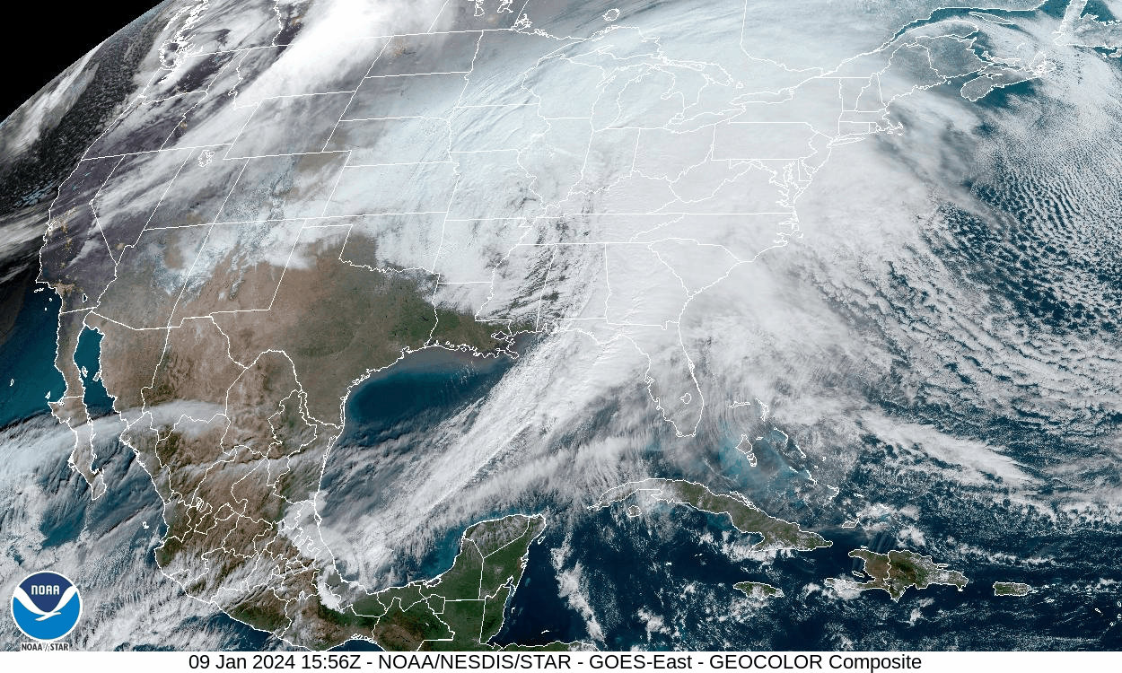
Winter weather in the eastern US is disrupting travel on Tuesday.  

Airlines have canceled more than 800 flights, and more than 4,200 flights arrived delayed, according to data from FlightAware.  

Some of the flight cancelations are due to the grounding of the Boeing 737 MAX 9 after a terrifying incident aboard one of its flights in which a section of the plane blew off the aircraft mid-flight.

United Airlines told CNN it canceled 170 flights Tuesday because of the MAX incident. 

Alaska Airlines has not said how many Tuesday cancelations are due to the MAX incident, but the airline has canceled between 140 and 170 flights daily since the FAA-mandated grounding, pending inspections of the planes.   

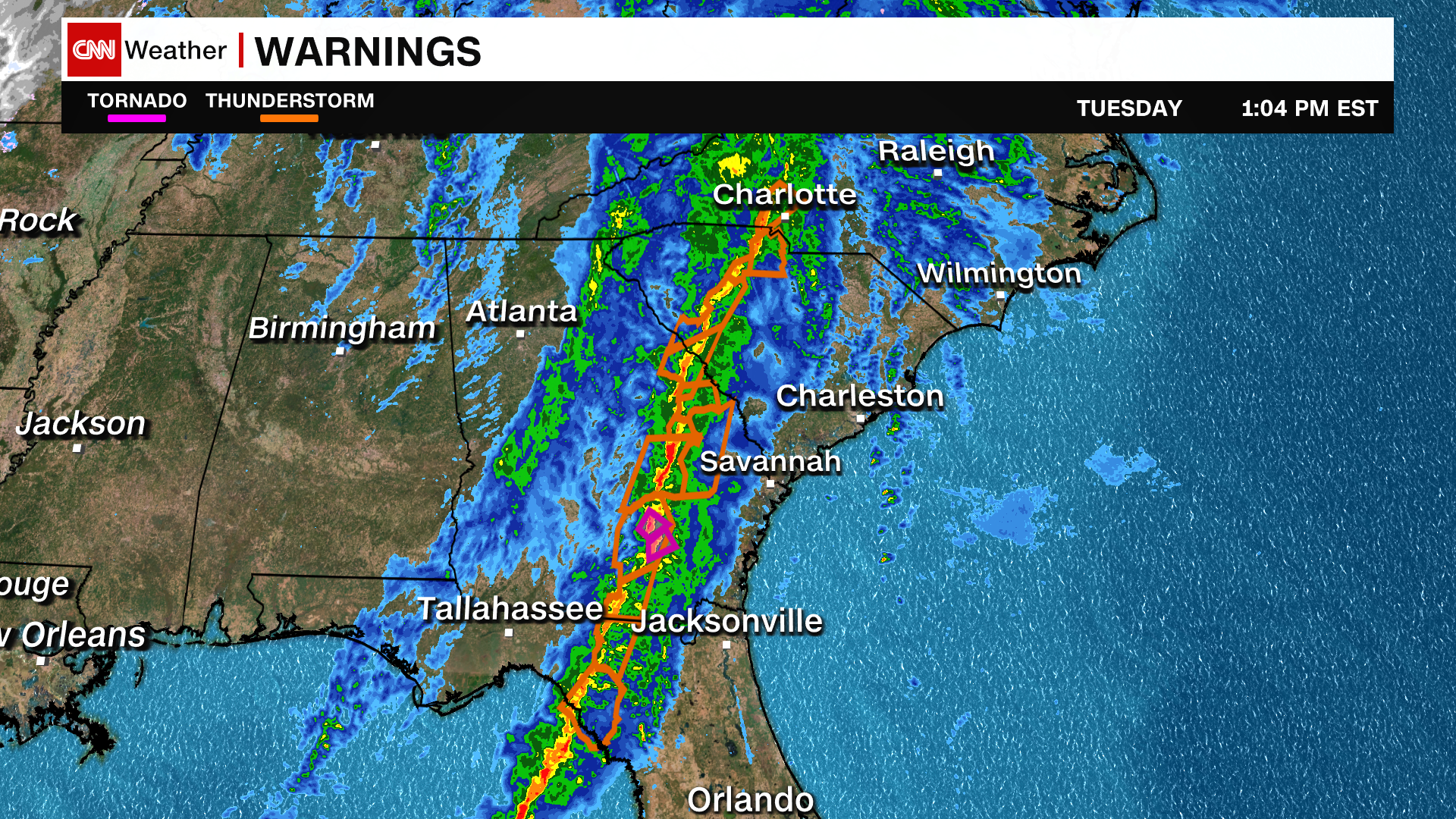
Citing thunderstorms, the Federal Aviation Administration ordered a broad hold on Charlotte-bound departures that applies to airports from Texas to Indiana and Miami to Washington, DC.

Earlier in the day, the FAA also held flights bound for Atlanta — the world’s busiest airport — and Dallas Fort Worth in Texas. 

The FAA warned of afternoon and evening disruptions along the East Coast, from Florida to New York. It has closed some flight routes due to thunderstorms, causing it to hold some Florida-bound flights.

On the nation’s rails, Amtrak canceled multiple East Coast trains for Tuesday and Wednesday. It has either canceled or shortened the routes for more 17 Acela, Northeast Regional and Keystone trains today and tomorrow.  

1:44 p.m. ET, January 9, 2024

There's more than 400 miles of active severe thunderstorm warnings across Southeast

From CNN Meteorologist Mary Gilbert

An unbroken line of severe thunderstorm warnings stretched across about 450 miles of the Southeast early Tuesday afternoon as damaging storms pounded the region.

Severe thunderstorm warnings mean there is an "imminent danger to life and property" from potentially destructive winds and hail, according to the National Weather Service.

These warnings all stem from the same line of damaging thunderstorms.

When severe thunderstorms rumble to life, they can develop separately from one another and remain their own individual storms. Individual storms can also eventually merge into one cohesive, powerful line. The latter has been the case Tuesday as the potent line of severe thunderstorms expands its reach across the Southeast.

Damaging wind gusts and tornadoes remain the main threats with any severe thunderstorms Tuesday, but hail and flooding rainfall are also possible.

1:03 p.m. ET, January 9, 2024

Here's what the massive storm looks like from space

From CNN Meteorologist Mary Gilbert

This satellite animation provides a complete snapshot of the storm encompassing much of the eastern half of the US Tuesday. The storm and its associated cold front form a distinct comma shape – a hallmark of non-tropical storms.

The storm’s center — the comma’s head — hovers over the Mississippi Valley, while its long cold front — the comma's tail — stretches from the eastern US to Mexico.

Much of the East is obscured by the storm’s thick cloud cover, making it difficult to get any peeks at the surface below. But clear skies in the Southwest reveal snow in the mountainous areas of Arizona and New Mexico.

Both states were the first to feel the storm’s impacts when it brought rain and snow to the desert on Sunday. It later moved across the central US Monday.

12:23 p.m. ET, January 9, 2024

Second tornado watch issued for coastal Southeast

From CNN Meteorologist Monica Garrett

More than 9 million people are under a new tornado watch issued by the Storm Prediction Center until 6 p.m. ET.

Portions of northern Florida, southeastern Georgia, south central North Carolina and much of South Carolina are under the watch — including Jacksonville in Florida, Savannah in Georgia, Charlotte in North Carolina, and Columbia and Charleston in South Carolina.

“A line of fast-moving thunderstorms will sweep eastward across the watch area this afternoon, posing a risk of damaging wind gusts and a few tornadoes,” the SPC said.

There have been 12 tornadoes reported across Florida, Alabama and Georgia this morning associated with this line of storms.

1:00 p.m. ET, January 9, 2024

Over 100,000 customers are without power in Florida

A massive winter storm has knocked out power to more than 100,000 customers in Florida alone as of 1 p.m. ET Tuesday, according to poweroutage.us.

The winter storm is bringing blinding snow, tornadoes and winds gusting over 50 mph from the Plains to the East Coast. The South has the most power outages on Tuesday morning, where a strong line of thunderstorms is moving through. 

This storm will continue to push eastward and is likely to cause more power outages as it reaches the high population areas of the East Coast, where the ground is also saturated and high winds are expected.

These are some of the top outages by state:

  • Florida: 101,000+
  • Georgia: 64,000+
  • Alabama: 36,000+
  • Missouri: 33,000+
  • Kansas: 32,000+
  • Pennsylvania: 31,000+

12:21 p.m. ET, January 9, 2024

Hurricane-force wind gusts possible in North Carolina as storm slams East Coast

From CNN Meteorologist Mary Gilbert

Wind gust forecast for Tuesday evening.
Wind gust forecast for Tuesday evening. CNN Weather

Intense winds are forecast to pound parts of the East Coast Tuesday evening through Tuesday night, raising concerns for significant damage, power outages and coastal flooding.

Some of the strongest winds will center on North Carolina.

Tropical-storm-force wind gusts of 40 to 60 mph are likely across the eastern half of the state Tuesday evening, with hurricane-force gusts near 75 mph possible in the Outer Banks.

These strong winds are tied to the considerable strength of the storm slamming much of the East with adverse weather. But a layer of strong winds located in the low atmosphere called the low-level jet will also lend a helping hand.

Severe thunderstorms are forecast to rock a large part of the Carolinas later Tuesday. When they do, these storms will build high enough into the atmosphere to tap into the low-level jet and send its strong winds rushing toward the surface.

More concerning, the low-level jet is expected to be “unusually strong for this time of year” and could possibly become the strongest ever recorded during winter for the area, according to the National Weather Service in Morehead City, North Carolina.