There is "significant damage" in Panama City Beach area after tornadoes sweep through, local officials say

January 9, 2024 - Winter storm slams central and eastern US

By Antoinette Radford, Adrienne Vogt, Aditi Sangal, Maureen Chowdhury and Emma Tucker, CNN

Updated 12:00 a.m. ET, January 10, 2024
16 Posts
Sort byDropdown arrow
10:49 a.m. ET, January 9, 2024

There is "significant damage" in Panama City Beach area after tornadoes sweep through, local officials say

From CNN’s Chris Boyette

A house is seen teetering on its side in the Grand Lagoon area of Panama City, Florida, as severe weather, including tornadoes, passed through the Florida panhandle on Tuesday morning.
A house is seen teetering on its side in the Grand Lagoon area of Panama City, Florida, as severe weather, including tornadoes, passed through the Florida panhandle on Tuesday morning. WJHG

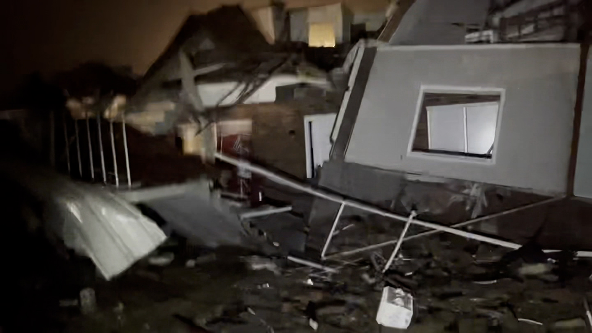
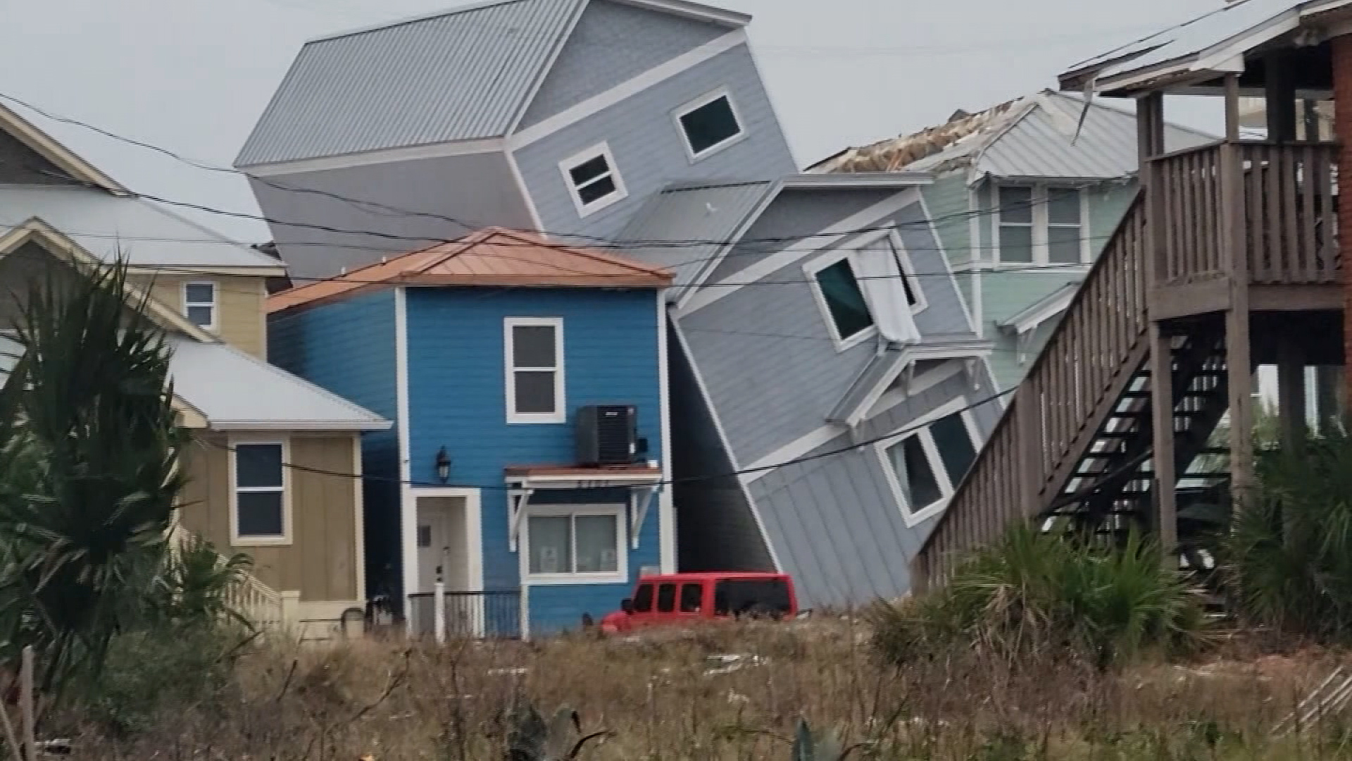
Bay County, Florida, Emergency Management Services reported “significant damage” as severe weather, including tornadoes, pass through the Florida Panhandle.

“We are receiving reports of significant damage in some parts of Bay County, including Thomas Drive at Panama City Beach, St. Andrews, and Resota Beach Road in Southport,” the county posted on Facebook. “Another cell is making its way this direction, so please stay inside if possible.”

The county said the Grand Lagoon Bridge is closed due to debris in the roadway and Bayway transit services were suspended.

Bay County Sheriff Tommy Ford urged people to take cover.

Storm damage is seen in Panama City Beach on Tuesday.
Storm damage is seen in Panama City Beach on Tuesday. WJHG

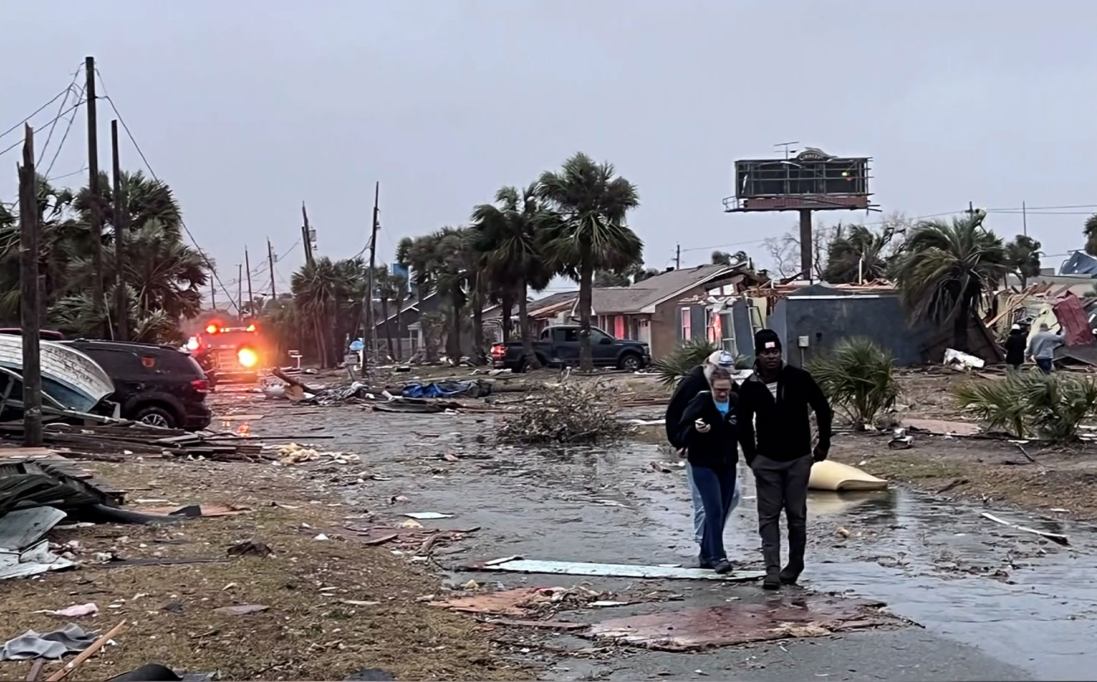
“We’ve had multiple tornadoes on the ground, primarily in the county … numerous reports of damage; we’ve rescued people out of structures,” Ford said in a video posted online, encouraging residents to shelter in a safe space inside their homes.

Photos shared by the Panama City Police Department showed trees fallen across roads and onto driveways, plus collapsed fences in the St. Andrews area.

9:22 a.m. ET, January 9, 2024

More power outages in Southeast as intense line of thunderstorms moves through region

From CNN Meteorologist Monica Garrett

CNN
CNN

A widespread winter storm has knocked out power to nearly 300,000 customers across the eastern half of the US as of 8:45 a.m. ET Tuesday morning, according to poweroutage.us.

The winter storm is bringing blinding snow, tornadoes and winds gusting over 50 mph from the Plains to the East Coast. The South has the most power outages on Tuesday morning, where a strong line of thunderstorms is moving through. 

This storm will continue to push eastward and is likely to cause more power outages as it reaches the high population areas of the East Coast, where the ground is also saturated and high winds are expected.

These are some of the top outages by state:

  • Alabama: 60,000+
  • Florida: 57,000+
  • Georgia: 46,000+
  • Kansas: 42,000+
  • Texas: 23,000+
  • Louisiana: 20,000+
  • Mississippi: 13,000+

An additional 50,000-plus customers are without power across the Pacific Northwest, where a second winter storm is impacting the region. Washington has about 42,000 customers without power and Oregon has about 10,000 customers out.

8:18 a.m. ET, January 9, 2024

Over 160 million people face wind threats Tuesday. Here's what's behind the strong, prolonged winds

From CNN Meteorologist Mary Gilbert

Widespread wind gusts of 40 to 60 mph are likely across much of the central and eastern US as a massive, multi-faceted storm reaches its full strength Tuesday.

More than 160 million people across the US are under wind alerts, and the Weather Prediction Center warned them to "prepare for power outages."

Severe storms aren't driving these strong, prolonged winds — it's the impressive strength of the storm, which is an area of low pressure, and how it interacts with a strong area of high pressure located off the northeastern coast of the US.

The atmosphere is exerting pressure on all of us. The force of that pressure is lower under areas of low pressure and higher under areas of high pressure, hence the names.

As the storm gets stronger, its pressure drops and it creates a stronger gap in pressure between it and the high pressure, known as a pressure gradient.

The speed of the wind is related directly to the strength of the pressure gradient because it squeezes the air that moves through it, forcing it to pick up speed. Think of it like popping bubble wrap: Once it’s squeezed hard enough, the plastic pops and the air quickly rushes out.

The strength, duration and widespread nature of winds on Tuesday and Tuesday night in this pressure gradient are likely to bring down trees and cause power outages.

9:26 a.m. ET, January 9, 2024

Multiple tornadoes reported in Florida Panhandle, including near Panama City

From CNN Meteorologists Mary Gilbert and Brandon Miller

Tornado damage is seen a screengrab taken from video shared by storm chaser Jay Lesyk. Lesyk said he was in Grand Lagoon, Florida when he observed a tornado hit the area early Tuesday morning.
Tornado damage is seen a screengrab taken from video shared by storm chaser Jay Lesyk. Lesyk said he was in Grand Lagoon, Florida when he observed a tornado hit the area early Tuesday morning. Jay Lesyk

Several tornadoes have been reported this morning in the Florida Panhandle as a strong line of thunderstorms moves through the area.

National Weather Service meteorologists reported a “large and extremely dangerous tornado” near Panama City just after 5:30 a.m. CT (6:30 a.m. ET).

"This is a PARTICULARLY DANGEROUS SITUATION," the weather service added.

The tornado continued to track northeast, passing near Lynn Haven, Florida, shortly before 7 a.m. ET.

"To repeat, a tornado is on the ground. TAKE COVER NOW!" the weather service warned.

Social media videos from the area at that time appear to show a strong waterspout moving onshore as well as damage after the storm passed.

NWS meteorologists continue to track the storm, which is confirmed to still be producing a dangerous tornado near the town of Marianna, passing Interstate 10.

At least five tornadoes have been reported in the last couple of hours, according to data from the Storm Prediction Center.

7:56 a.m. ET, January 9, 2024

Tornado watch issued for portions of Florida, Alabama and Georgia

From CNN's Monica Garrett

A new tornado watch is in effect until 2 p.m. ET for portions of southeastern Alabama, the eastern Florida Panhandle to northern Florida, and southern Georgia, according to the Storm Prediction Center.

This watch covers over 2 million people and includes Tallahassee, Panama City and Lake City in Florida, Dothan in Alabama, and Albany and Valdosta in Georgia.

A strong line of storms, with potentially tornadic circulations and damaging straight line winds up to 75 mph, will sweep eastward across the watch area through the remainder of the morning into early afternoon.

“A few supercells also are possible ahead of the line with a threat for tornadoes (some strong), severe gusts and isolated hail,” the SPC said.

Over 40 million people across the Southeast are at risk of severe storms today. A Level 3 of 5 risk of severe storms covers much of Florida, Georgia and the Carolinas on Tuesday, where tornadoes and damaging winds are possible.

7:17 a.m. ET, January 9, 2024

Power outages across southern and central US affect more than 240,000 customers

High winds continue to impact much of the central and southern US, which has increased power outages to over 244,000 customers, according to poweroutage.us

Here the states with the highest power outages as of 7:15 a.m. ET:

  • Alabama: 64,000+
  • Washington: 61,000+
  • Georgia: 37,000+
  • Kansas: 34,000+
  • Texas: 29,000+
  • Louisiana: 19,000+

More than half the US population is currently under wind alerts that cover almost all of the South and extend into the Northeast. The bulk of the high wind alerts across the Southern Plains will begin to expire through the day on Tuesday but will largely last into Wednesday for much of the eastern US. 

10:22 a.m. ET, January 9, 2024

How to stay safe indoors (and outdoors, if you must) during a winter storm

From CNN's Jacqueline Howard

A local resident clears overnight snow from a driveway on Tuesday in Urbandale, Iowa.
A local resident clears overnight snow from a driveway on Tuesday in Urbandale, Iowa. Charlie Neibergall/AP

A powerful storm packing nearly every winter weather threat is making its way across the central and eastern US today.

When staying indoors during cold temperatures or a winter storm, the US Centers for Disease Control and Prevention offers these tips:

  • Make sure any infants younger than 1 year old are not sleeping in cold rooms and have adequate warm clothing, such as footed pajamas, one-piece wearable blankets or sleep sacks. Remove any pillows or other soft bedding from a baby’s crib, since they pose the risk of smothering or sudden infant death syndrome.
  • If you have friends or neighbors older than 65, check on them frequently to ensure that their homes are adequately heated.
  • Leave water taps slightly open to prevent freezing pipes.
  • Eat well-balanced meals to stay warm.
  • Avoid alcohol and caffeine, because they can cause your body to lose heat more rapidly.

And if you must go outside, the CDC and National Weather Service have some recommendations for staying safe while venturing outdoors during a winter storm,

  • Dress warmly with hats, scarves and mittens and by wearing layers.
  • Avoid walking on ice and avoid getting wet.
  • If you have to shovel snow or do other outdoor work, take your time and work slowly. If you have older neighbors, offer to help shovel their walkways or driveways.
  • Avoid traveling on ice-covered roads if possible.
  • If you are stranded outdoors, it is safest to stay in your vehicle.
  • Try to keep pets indoors during cold weather, but if they go outside, thoroughly wipe their legs and underbelly free of snow when returning indoors. Never let your dog off leash on snow or ice.

Read more about how to stay safe during winter weather.

6:44 a.m. ET, January 9, 2024

Dangerous storms capable of producing tornadoes are tracking along the Gulf Coast

From CNN Meteorologist Mary Gilbert

Radar snapshot as of 6:30 a.m. ET.
Radar snapshot as of 6:30 a.m. ET. CNN Weather

Intense storms are moving through portions of Florida and Alabama early Tuesday morning, unleashing torrential rainfall, strong winds and even a few tornadoes. Multiple tornado warnings were issued in each state during the predawn hours Tuesday.

Downtown Mobile, Alabama, was under at least two separate tornado warnings early Tuesday. But the threat has since shifted east into the Florida Panhandle, where at least one confirmed tornado moved through Freeport, Florida, on Tuesday morning, according to the National Weather Service in Tallahassee, Florida.

The damaging storms capable of producing tornadoes will continue to develop and form into a cohesive line of dangerous storms throughout Tuesday morning. This formidable line of storms will track east and unload severe weather across other portions of the Southeast Tuesday afternoon and evening.

7:25 a.m. ET, January 9, 2024

North Carolina governor declares state of emergency

From CNN’s Joe Sutton

North Carolina Governor Roy Cooper is pictured during a rally at Shaw University in Raleigh, North Carolina, on October 10, 2023.
North Carolina Governor Roy Cooper is pictured during a rally at Shaw University in Raleigh, North Carolina, on October 10, 2023. Karl B DeBlaker/AP/File

North Carolina Gov. Roy Cooper declared a state of emergency on Monday ahead of the severe weather that is expected to impact the state today.

"This storm system has the potential to bring high winds and other dangerous storm conditions to North Carolina, and people should be aware and take precautions,” Cooper said in a news release.

Be sure your emergency kits are up to date and pay attention to the weather in your area, especially any weather alerts such as flash flood warnings."

The storm threat is expected to increase into Tuesday afternoon.

“The severe weather threat has increased with numerous severe storms capable of producing damaging wind gusts and tornadoes possible Tuesday afternoon through Tuesday night, especially in the eastern half of the state,” the news release noted.