Over 40 million people are under severe storm threat Tuesday
There are over 40 million people under a severe storm threat on Tuesday, according to the latest from the Storm Prediction Center.
An enhanced risk for severe storms, or a level 3 of 5, is in effect from the Florida Panhandle to the Carolinas, including Jacksonville, Tallahassee, Savannah, Charleston and Wilmington.
The main threats are strong tornadoes, some of which could be EF2 to EF5 and strong wind gusts, some of which could exceed 74 mph.
A slight risk for severe storms, level 2 of 5, is in effect from central Florida to southern Virginia, including Charlotte, Raleigh and Tampa.
The main threats are tornadoes and damaging wind gusts.
A marginal risk for severe storms, level 1 of 5, spreads from southern Florida to central Virginia, including Virginia Beach, Atlanta, Miami, and Norfolk.
The main threats are isolated tornadoes, wind gusts and large hail.
Heavy rainfall is associated with the bulk of these storms. Flood watches are currently in effect for cities like Atlanta, Charlotte, Washington DC, Philadelphia and New York City, where rainfall of 2 to 4 inches is possible, with isolated totals exceeding 4 inches.
5:20 a.m. ET, January 9, 2024
Why the last storm makes this one even more dangerous
From CNN Meteorologist Mary Gilbert
Heavy rain will deluge much of the East on Tuesday, raising the flood threat from Florida to New England.
But there's even more risk in parts of the Northeast, where snow lingers from the past weekend’s snowstorm.
When the snow melts, the water the snow kept locked up above the ground is now free to flow. Throw heavy rain on top of that water, and it creates a higher flood threat than either can do alone.
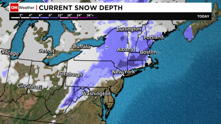
Snow depth across the Northeast as of January 9. Areas where rain combines with warmer temperatures to melt snow could amplify the flood threat.
How much additional water gets added into the flooding equation depends on how much water the snow contains, a measurement called snow water equivalent. In two equal-sized samples, heavy, wet snow will have a higher snow water equivalent – and therefore more water – than light, powdery snow.
When snowmelt is combined with heavy, falling rain, the runoff causes area rivers and streams to swell up or overflow.
But the rain on its own doesn’t melt the snow to a significant extent. It’s actually the warm air and the rain that melts snow considerably.
Temperatures will be very mild for January across much of the Eastern Seaboard as rain falls. New York City and Philadelphia will be in the 50s during the deluge later Tuesday and into Wednesday. Temperatures in Boston will hover near 40 degrees as rain drenches the area.
6:27 a.m. ET, January 9, 2024
Massive winter storm brings blizzard conditions to Midwest and threatens Southeast with tornadoes
From CNN's Elizabeth Wolfe, Robert Shackelford and Joe Sutton
Snow falls on the Iowa State Capitol in Des Moines, Iowa, on January 8. Chip Somodevilla/Getty Images
A vast and disruptive storm is set to whip up miserable morning commutes as it blasts the Midwest with heavy snow and blizzard conditions while also blanketing the Southeast with damaging winds, rain and possible tornadoes – conditions that are expected to expand into the Northeast later Tuesday.
More than 40 million people are under severe storm threat on Tuesday with weather alerts stretching more than 2,000 miles from New Mexico to Maine, according to the Storm Prediction Center.
The system has already hit the South with hail storms, significant flooding and tornado threats and unleashed perilous blizzard conditions in parts of the central US, shutting down several highways and stranding drivers in frigid temperatures.
Amid severe blizzard conditions in Kansas on Monday, the state highway patrol said it had responded to more than 300 calls for help and nearly 70 crashes. But whiteout conditions were making it difficult to see and authorities were having difficulty with rescues, one trooper said on social media.
Widespread power outages are expected Tuesday as strong winds threaten to topple power poles and down trees in areas where the ground has been saturated by rain.
More than 200,000 homes and businesses in six states are already experiencing outages, mainly in Kansas, Alabama and Washington, according to tracker poweroutage.us.
Here’s what to expect Tuesday:
• Tornadoes threaten Southeast: More than 11 million people from the Florida Panhandle to North Carolina are at risk of seeing tornadoes, including some strong ones with winds over 110 mph. That includes metropolitan areas such as Jacksonville, Florida and Charleston South Carolina. A tornado watch is also in effect until 8 a.m. ET for southern parts of Louisiana, Mississippi and Alabama and the western Florida Panhandle.
• Rain could trigger damaging flooding: Flooding is a significant concern in areas where heavy rainfall is soaking already saturated ground. Several major metropolitan areas along the East Coast could see flooding, including Atlanta, Georgia, Washington, DC and New York City, where rainfall of 2-4 inches is possible.
• Strong winds threaten widespread power outages: Gusty winds could also cause widespread power outages Tuesday as more than half the US population – in areas stretching from the South to the Northeast – are under wind alerts.
• Treacherous blizzard conditions shift east: Blizzard warnings spread from New Mexico to Nebraska through Tuesday morning as the threat shifts from the Plains to the Midwest. Another 2-6 inches of snowfall are possible in the area, along with winds of up to 70 mph.
• Up to a foot of snow possible from central US to Northeast: Winter storm alerts are in effect for areas of eastern Kansas, Nebraska and eastern Wisconsin, as well as interior parts of the Northeast and New England. Widespread snowfall between 6-12 inches is possible and some areas could see even more. The snowfall will begin to let up in the central US on Tuesday and in the Midwest, Great Lakes and Northeast on Wednesday.