
At the halfway point of August, fall is quickly approaching as schools are back in session. But warm temperatures and prolonged drought could hinder the traditional fall feeling of cool, crisp mornings with beautiful foliage on the trees.
The Climate Prediction Center’s (CPC) extended three-month outlook for September through November is showing a similar story for most of the country – above average temperatures.
The CPC has also increased chances for La Niña this fall. While this could be good news for the drought-stricken western states, it does not bode well for areas impacted by tropical systems in the Atlantic.
Fall foliage impacted by drought
When you think of fall, the first thing that usually comes to mind is leaves changing to beautiful reds, oranges and yellows. This year those colors may look a little different thanks to the drought.
Perfect foliage conditions rely on a good combination of temperature and moisture. The processes in photosynthesis use different chemical compounds that create different colors. Most of the chemicals need sunshine to create vibrant colorful displays during autumn. But sunshine alone is not enough; trees also need rain.

The problem this year is that some areas have experienced extreme conditions, particularly in the West.
A lack of rain in the West will cause many trees, especially shallow-rooted ones like maples or birches, to go into survival mode, “shutting down” early and preparing for winter.
This stressful condition causes leaves to turn brown and fall off before they reach their peak color. The leaves that do change color will do so very briefly and can have more muted colors than normal.
However, not all drought is bad. Mild drought can actually trigger more vibrant colors, though a lot of this depends on how much rain fell the year before. The weather during previous growing seasons can have a delayed effect.
The duration of the leaf color can be impacted by causing leaves to fall off prematurely. Prolonged and extreme drought can cause physical damage to trees making it harder for trees to protect themselves against pests and disease, and slow their overall growth.
Some locations will probably see fall colors earlier than usual this year, and they won’t last as long as previous years.
Sweater weather could be sweltering
It could take a little while longer than average to feel the brisk cool evenings or chilly morning walks to school associated with fall in the US.
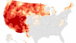
Nationwide, warmer fall temperatures are anticipated for the next three months. The Southwest and Northeast could experience the most anomalously above average temperatures, according to the CPC outlook for September, October and November.

The autumnal equinox is September 22, marking the first day of fall, but the outlook puts warmer weather on tap through at least November.
Although the temperatures could be warmer than average, it doesn’t mean things won’t cool off. Cooler temperatures will start to roll across much of the country, but they might not be as cold as usual.
The Northeastern US typically sees temperatures begin to fall into the 60s and 50s by the time September arrives. The above-average outlook could mean 50s won’t be commonplace until around Thanksgiving.
In the Southwest, the colder months normally only see temperatures dip into the 70s. Warmer conditions are likely to stick around longer for the region.
Alongside the above normal temperatures, the next three months could see another dry spell for the West that could perpetuate the drought and worsen wildfire activity.

The CPC outlook shows below normal precipitation for the western states, centered over the desert Southwest. Peak fire season for the area normally lingers through October, which could spell bad news with the pairing of warmer temperatures and dry conditions.
Up north, the Pacific Northwest might get higher than average rainfall, a good change of pace from the increasing drought conditions and fire activity in the region throughout the summer.
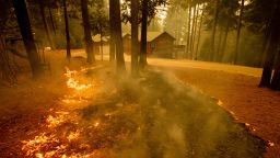
Peak fire season could ignite
Fall may be known as a cooler season, but some regions of the US know it as the peak of fire season.
This year’s fire season has already experienced explosive activity. Massive fires in the Northwest and California have scorched millions of acres of land.
Peak fire season is different in varying parts of the country, where monsoon, tropical patterns, and other climatological elements impact wet and dry patterns differently.
“The peak of the western fire season usually occurs from late July through mid-August based on fire activity and firefighting resources committed,” Nick Nauslar, meteorologist for the NICC/NIFC Predictive Services said. “The western fire season usually begins to slow in September and October, but offshore wind-driven fires in California remain possible during the fall. Southeast portions of the US also have a fall fire season.”
The new climate outlook indicates that hot and dry weather is here to stay in the region, although the bull’s eye may shift slightly into the southwest, continuing the overactive fire season.
“Above normal significant fire potential is forecast to continue through September for much of the Northwest, Northern Rockies, and northern portions of the Great Basin and Rocky Mountain Geographic Areas,” said the National Interagency Fire Center.
Through September the mountains and foothills of California are expected to have raised fire potential, and offshore winds could drive an above average threat in southern California through October and November.
California has battled enormous fires this summer including the Dixie Fire which has consumed hundred of thousands of acres to become the state’s second largest fire in history.
The historic drought in the West has fueled the rampant fire activity, with little moisture providing relief for California and the Pacific Northwest amid rounds of heat waves. Drought is expected to worsen across the West throughout the fall, perpetuating the already dire situation.
Monsoon season brought a welcome reprise in drought conditions to the desert Southwest, specifically Arizona, during the height of the summer. But the autumn outlook could be dire as the drought is expected to return in full force across the region.
Vegetation was able to regrow across the Southwest with the plentiful moisture brought by the monsoon to Arizona and the surrounding states, but this could end up fueling more wildfires as it dries out in the coming months.
It may take the return of rainy season in the West and a few atmospheric river events to finally relieve the scathing fire season.
La Niña looking to make a return
The potential for La Niña emerging in September, October, and November is growing.
Since La Niña does not inhibit tropical development, experts are concerned about the potential impact on an already record-breaking hurricane season.
The chances of a La Niña weather pattern occurring have now increased to 60% just weeks before peak hurricane season in the Atlantic, which forecasters say could lead to a busy rest of the season.
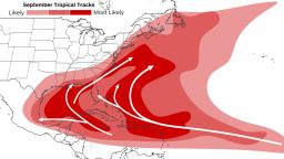
With Henri impacting the Northeast this weekend there have already been eight named storms, and peak hurricane season is still a few weeks away. Typically, there are not eight named storms until September 24, across the Atlantic Ocean.
“Climatologically, what ends your hurricane season is too much wind shear, so La Niña tends to prolong the hurricane season since it tends to reduce shear,” said Phil Klotzbach, a research scientist at Colorado State University. “Of course, last year is an example of La Niña prolonging the season … on steroids.”
La Niña’s tendency to reduce vertical wind shear – the changing of wind direction and wind speed with height – allows for more storms because too much shear tears apart hurricanes.
The CPC has a La Niña watch in place, but will switch to a La Niña advisory when conditions are finally observed.
La Niña doesn’t just affect oceans – it also affects the weather over land, too. During a La Niña winter, warmer and drier conditions usually arise from South California to South Carolina.
Quite the opposite occurs in areas of Northern California as well as Oregon and Washington, where wetter conditions usually prevail. This would be welcome news since those areas are currently dealing with record drought. However, this also tends to lead to heavy rains and flooding in the Pacific Northwest US and Canada.

