The chances of La Niña weather patterns occurring have now increased just weeks before peak hurricane season in the Atlantic, which forecasters say could lead to a very busy rest of the season.
“Climatologically, what ends your hurricane season is too much wind shear, so La Niña tends to prolong the hurricane season since it tends to reduce shear,” said Phil Klotzbach, a research scientist at Colorado State University. “Of course, last year is an example of La Niña prolonging the season … on steroids!”
La Niña’s tendency to reduce vertical wind shear – the changing of wind direction and wind speed with height – is important because too much shear tears apart hurricanes.
The Climate Prediction Center’s (CPC) latest forecast update, issued Thursday, further shows their confidence that La Niña could form this autumn. In fact, the La Niña Watch has now increased to 60% for this fall.
Last year at this time, we were also looking at a 60% chance of La Niña occurring. Just one month later, the CPC announced that La Niña had arrived.

When a La Niña Watch is issued, it simply means that conditions are favorable for development within the next few months. An advisory can then be issued once La Niña weather conditions are observed.
This is why La Niña matters
La Niña is essentially the “cool phase” of the El Niño-Southern Oscillation (ENSO) climate pattern, which is a naturally-occurring phenomenon that involves fluctuating ocean temperatures in the Pacific.
La Niña is the opposite of El Niño, which is the warm phase of the cycle.
In a typical El Niño phase, much of the Pacific Ocean is characterized by warmer waters, whereas La Niña features a cooling of those same Pacific waters. More importantly, especially in the case of hurricanes, La Niña weakens high atmospheric winds, which allows warm air pockets to grow vertically and develop into hurricanes.
The opposite occurs during an El Niño, which causes cool, dry, and atmospherically unfavorable conditions in the Atlantic.
We’ve seen this phenomenon in the past, where after La Niña has formed, the hurricane season ends with above-average activity. Specifically, the years 2000, 2005, 2008, 2010, 2011, and 2012 were all La Niña years with above average hurricane seasons, and no one can forget 2020’s record-setting season – also a La Niña year.
Comparing the 2021 season to last year’s historic hurricane season
Since La Niña does not inhibit tropical development, experts are concerned about the potential impact on an already record-breaking hurricane season.
This is troubling because we have already had a very active hurricane season across the Atlantic, with six named storms and peak hurricane season is still weeks away. Typically, there are not six named storms until September 8, across the Atlantic Ocean.
Essentially La Niña allows for more tropical storms to develop, but where they travel and ultimately make landfall has more to do with climatological statistics.
“In August, the typical origin point for a tropical system to form is near the Leeward and Windward islands in the Caribbean, where Fred formed and where Grace is likely to form,” says Haley Brink, CNN Meteorologist.
“By September, when peak hurricane season is, this origin area greatly expands to include much of the Caribbean, the Gulf of Mexico, and the western Atlantic as tropical waves track west off the coast of Africa,” Brink said.

There are a lot of comparisons out there to the record-breaking 2020 Atlantic hurricane season because not only is this year’s hurricane season currently on pace to match the number of named storms, it also happened to be a year where La Niña occurred in the autumn.
“La Nina was certainly a significant enhancing factor in last year’s hurricane season,” Klotzbach said. “We had five major hurricane formations after 30 September. The most major hurricane formations in October-November in any season prior to 2020 was two. Talk about shattering a record!”
What does La Niña mean for the continental US?
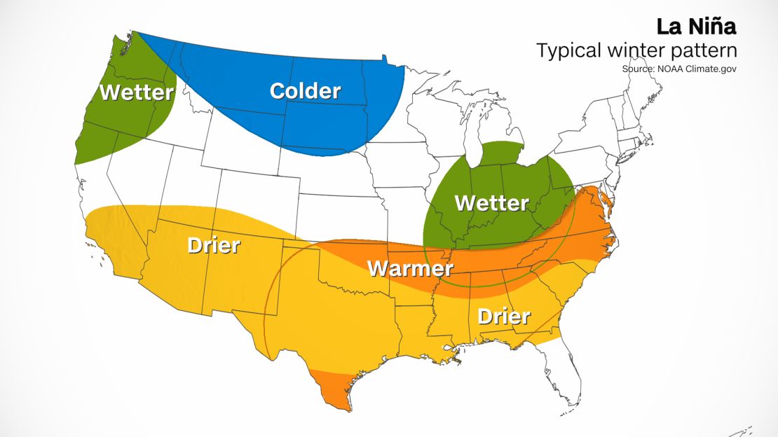
La Niña doesn’t just affect oceans – it also affects the weather over land, too. During a La Niña winter, warmer and drier conditions usually arise from South Carolina to Southern California.
Quite the opposite occurs in areas of Northern California as well as Oregon and Washington, where wetter conditions usually prevail. This would be welcome news since those areas are currently dealing with record drought.
In La Nina years, colder waters in the Pacific Ocean push the jet stream northward. This tends to lead to heavy rains and flooding in the Pacific Northwest US and Canada.