Experts fear an already active hurricane season could come to an eventful and exceptional end as unusually warm, storm-boosting ocean temperatures and a slow-to-emerge El Niño combine.
The Atlantic season and its 18 named storms has already been above average, according to Phil Klotzbach, a hurricane researcher with Colorado State University.
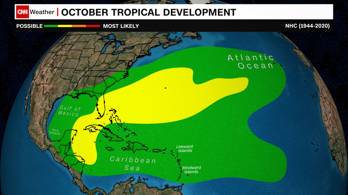
But October usually signals changes in activity and the areas where storms form. The first half of October is typically the final stretch of the busiest time of the Atlantic hurricane season.
The number of storms usually begins to drop off quickly toward the end of October and craters by the time the season ends on November 30.
Storms that do form typically do so in areas that are much too close for comfort – in the Gulf of Mexico, near the Bahamas and the western Caribbean – rather than in the open Atlantic, where storms like Category 5 Hurricane Lee formed earlier this year.
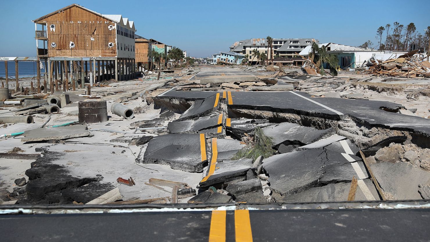
This means places like Florida, which was devastated by Category 5 Hurricane Michael’s landfall in October 2018, need to be on particular guard in a normal October.
However, extremely high sea surface temperatures across the Atlantic “expand the reach of where something might form” into the late season this year, Brian McNoldy, a Senior Research Associate at the University of Miami, told CNN.
This could mean more storms develop late into the season in the main development region, a large section of the open Atlantic Ocean that stretches from Africa to the eastern Caribbean. If this were to happen, parts of the eastern Caribbean, Bermuda and the East Coast could still be at risk for tropical strikes.
The battle between warm ocean water and the effect of El Niño has posed a forecasting challenge throughout this hurricane season, as one factor is seemingly negating the other.
El Niño typically causes strong upper-level winds in the Atlantic, which suppress hurricane activity. But weaker upper-level winds – which are more favorable for hurricanes to develop – tend to be associated with warmer ocean temperatures, which is exactly what we have seen this year, Fischer explained.
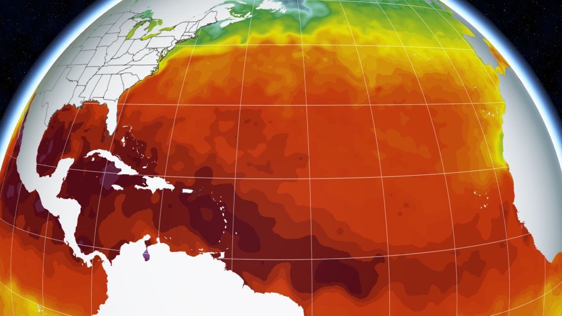
On balance, the warmer ocean temperatures and weaker winds are winning, and more storms have been able to form than would otherwise be possible in a typical El Niño year, Klotzbach previously told CNN.
This clash is expected to continue into October and November.
“Usually as we get into the back half of the hurricane season, El Niño tends to dominate, even if the Atlantic is warm. But we’ve just never seen anything this warm,” Michael Fischer, an Associate Scientist with the University of Miami, told CNN.
This could leave the Atlantic open to more tropical activity in general through the rest of the season, according to Fischer, but it remains to be seen.
“So we’re kind of in uncharted waters, if you will, and it’s tough to make any kind of confident forecast because of that,” Fischer told CNN.
One thing is for certain, though: Any tropical system that does form would likely get an “extra boost” in strength from the exceptionally warm water, according to McNoldy. This has already been demonstrated by multiple storms this season, including Hurricane Idalia and Hurricane Lee – both of which rapidly intensified while moving over extremely warm water.

It’s possible that upper-level winds will remain at abnormally low levels across the main development region and the Caribbean, where the effect of El Niño is typically most pronounced, according to Fischer. This, combined with high ocean temperatures, may leave nothing standing in the way of tropical development.
“Is El Niño at some point going to say, ‘Forget this, I’m in charge?’” Klotzbach said. “I don’t see massive signs of that.”
If conditions continue to be ripe for tropical development through the end of hurricane season, it’ll add onto what has already been an abnormal season.
“There are a lot of things going on this year that are unusual” in the Atlantic, Klotzbach added. “We have an Atlantic that’s in a different kind of league from other years.”

