Story highlights
Heavy snow forecast from Pennsylvania to Massachusetts on Tuesday
Snowfall rates of 2 inches per hour or more are possible
Travel could be 'very difficult to impossible,' weather service warns
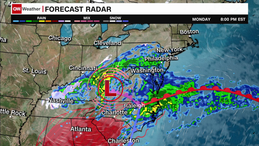
A quick but intense nor’easter could bring the biggest snowfall in more than two years to parts of the Northeast Tuesday, including New York City.
But the forecast is tricky and subject to last-minute changes. With the heaviest snow developing over a narrow area, small shifts in the track will make a big difference in how much snow falls.
The nor’easter – an East Coast storm driven by winds from the northeast – was expected to develop Monday night from the same sprawling system that soaked the Gulf Coast and Southeast over the weekend and Monday.
Rain had started in New York City by Monday night, and it’s expected to continue for a large part of the night before transitioning to snow early Tuesday morning, according to the National Weather Service.
Widespread heavy snowfall is forecast to set in overnight into Tuesday from Pennsylvania through southern New York and northern New Jersey, where winter storm alerts are in place.
More than 2 inches of snow per hour could fall across the impacted region Monday night and Tuesday morning – coupled with wind gusts as strong as 40 mph, the Weather Prediction Center said.
“Travel could be very difficult to impossible. Patchy blowing snow could significantly reduce visibility. The hazardous conditions will impact the Tuesday morning and evening commute,” the National Weather Service said in an alert.
The heaviest stretch of snow is expected to be quite narrow. Snowfall totals could vary drastically for cities separated by just 20 to 30 miles, and snow may struggle to accumulate at first before finally piling up quickly because of springlike temperatures leading up to the storm.
For New York City, the heaviest snow is forecast to occur just north of the densely populated metro. But a slight shift south in the storm’s track is possible and would mean more snow in the city.
A winter storm warning was issued for the city on Monday afternoon – the first in over two years.
Around 5 to 8 inches are forecast for the New York City area. Even if the city only picks up 2 inches of snow, it’ll be the biggest storm for the city since January 2022.
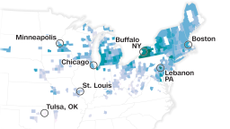
On Tuesday, the threat expands to southern New England where parts of Connecticut, Rhode Island and southern Massachusetts could see considerable snow.
Prolific snow in Boston was looking slightly less likely Monday afternoon as forecast models continue to hint at a southern shift in the storm track.
Some of the heaviest snow may end up falling south of Boston, targeting Providence, Rhode Island, or New Haven, Connecticut.
The snowy weather will be quite a change of pace for the region, as many cities in the Northeast are dealing with their warmest winter on record. But February is historically the snowiest month of the year for many of the region’s major cities because of nor’easters like this one.
Moderate coastal flooding could also occur during high tide Tuesday as strong winds blow across parts of the New Jersey, New York and New England coasts.
Storm cancels schools and triggers travel warnings
Local officials have begun gearing up for the incoming snow.
A travel advisory was issued for New York City for Monday night into Tuesday during the storm’s heaviest snow, the city’s emergency management department said.
“If you do not have to be on the roads tomorrow, please stay home, and, if you’re a property owner, remember to clear your sidewalks,” New York City mayor Eric Adams said in a news release.
All New York City Public Schools will operate via remote learning Tuesday, Adams said.
Classes are also cancelled Tuesday for Boston Public Schools, mayor Michelle Wu announced Monday.
Wu said the city was mobilizing the Public Works Department to treat the roads ahead of the several inches of expected snow and that a snow emergency and parking ban will go into effect at 10 p.m.
“Please stay off the roads tomorrow, wherever possible,” Wu said during a Monday news conference. “Make plans to be indoors, stay off the roads. It’s looking like it will come down pretty heavily and fast.”
Travel restrictions are likely in Rhode Island Tuesday, Gov. Dan McKee said in a Monday news conference, with the specific restrictions set to be announced later Monday afternoon.
“This storm will have a major impact on Tuesday morning commute and throughout most of the day,” McKee said.
CNN Meteorologists Sara Tonks and Elisa Raffa and CNN’s Celina Tebor and Sarah Dewberry contributed to this report.


