Severe thunderstorms capable of unleashing hail and tornadoes are set to thrash parts of the central Gulf Coast Sunday before spreading into the Southeast, with snow expected to sweep into the Northeast through the beginning of the week.
About 23 million people from eastern Texas to western Georgia are at risk of severe weather and thunderstorms Sunday, including Houston, New Orleans and Mobile, Alabama, according to the Storm Prediction Center.
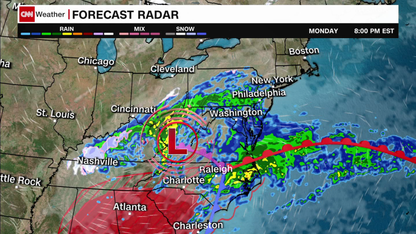
On Monday, the threat will shift farther east into parts of Georgia, the Florida Panhandle and South Carolina.
“Heavy rainfall is expected, and areas of the Mid-South in particular may see locally several inches of rain from instances of training showers and thunderstorms going through early Sunday. This will drive a threat for flash flooding,” the National Weather Service said.
States in the Southeast are facing the possibility of flash flooding on Sunday, with a level 1 out of 4 risk of excessive rainfall in place from Texas to North Carolina. Some areas could see rainfall rates Sunday up to 1 inch per hour, and rainfall totals by the end of Monday could surpass 2 inches.
A tornado watch for parts of Louisiana and Mississippi is in effect until 7 p.m. CT (8 p.m. ET) Sunday. The cities of Alexandria, Louisiana, and Jackson, Mississippi, are among the areas under threat of tornadoes, 70 mph damaging winds and tennis ball-sized hail.
“Scattered supercell development is expected this afternoon along and just south of a warm front from central Louisiana into central Mississippi, and storms will spread eastward through this evening,” the Storm Prediction Center said in a Sunday afternoon update.
“The most intense supercells along the front will be capable of producing a couple of strong tornadoes (roughly EF2 damage potential) and large hail of 1.75-2.5 inches in diameter. Occasional damaging gusts of 60-70 mph will also be possible.”
The severe risk slides east into Georgia and the Carolinas tomorrow. The same storm will drop up to a foot of snow across parts of the Northeast by Tuesday.
In New Orleans, raucous Mardis Gras parades may be dampened by rain showers Sunday. The weather service urged partygoers to “be weather aware while you’re enjoying your Mardi Gras celebrations!”
The wet weather across the South is fueled in part by a winter storm that is plotting a path from the Rockies into the Ohio River Valley and the Northeast through Tuesday, when it could bring heavy snow and possible travel disruptions.
Northeast braces for Nor’easter
The storm will shift northeast Sunday night through Monday, bringing heavy bands of snow from central Oklahoma to Ohio, the weather service said. Bands of snow will widen Monday night across much of the Northeast and southern New England through Tuesday, possibly bringing more than 8 inches of snow to some areas.
“Nor’easter forms Monday night into Tuesday,” the Weather Prediction Center said Sunday. “Powerful winds and heavy/wet snow could damage trees, power lines, and disrupt travel. Coastal Flooding is also expected.”
About 20 million people are under winter storm warnings or watches Sunday in the Northeast, stretching from central Pennsylvania to southern Maine.
A watch covering Pennsylvania through upstate New York was upgraded to a winter storm warning Sunday afternoon. The National Weather Service in Albany, New York, said some of the areas covered by the warning could see more than a foot of snow coupled with 35 mph wind gusts.
Snowfall rates of up to 1 to 2 inches will likely occur late Monday night into Tuesday morning. The exact location of the heaviest snowfall rates is still uncertain, the weather service said, warning the weather could make travel difficult or impossible.
Boston, Albany, and Scranton, Pennsylvania, are some of the cities included in the warning.
Powerful winds and dense, wet snow could accumulate on trees and power lines, threatening power outages or roadways blocked by trees, the center said.
Disruptive wind gusts up to 40 mph are also possible for cities along the East Coast on Tuesday, including New York and Boston.
New York Gov. Kathy Hochul on Saturday urged New Yorkers to watch the weather forecast and prepare for a storm system that could potentially cause hazardous travel conditions and power outages.
“As New Yorkers are preparing to celebrate Super Bowl Sunday, we are tracking a developing storm that will impact a substantial area of New York into the early part of the week,” Hochul said a statement. “I have directed State agencies to mobilize in preparation for this storm and urge everyone to watch for weather and travel updates as it develops.”
CNN Meteorologist Sara Tonks contributed to this report.

