Another powerful storm is preparing to unleash blizzard conditions, severe thunderstorms, damaging winds and brutal cold across the eastern half of the US in what will be a dangerous dose of déjà vu for many.
The new storm will place the same parts of the central and eastern US slammed by a massive storm earlier this week at risk once more – amplifying the potential impact for those still recovering.
But there are some key forecast differences for this storm compared to the last, particularly in the Chicago area, which missed out on significant snow earlier this week but could be blasted with blizzard conditions by Friday night.
The origins of the new storm are rooted in the Pacific Northwest, which was walloped by blizzard conditions on Tuesday and Wednesday.
Snow and blustery winds moved from the Northwest into the Four Corners region by late Wednesday. A round of snow will target the high elevations of Arizona and New Mexico through Thursday.
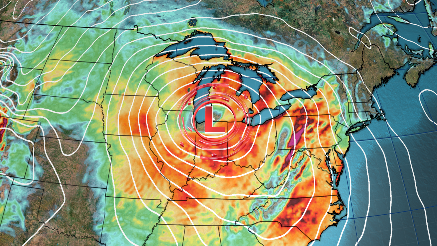
The storm will then morph into a much larger beast – its strengthening aided by a big push of atmospheric energy – as it exits the Plains by Thursday evening and sets the stage for a highly impactful event in the central and eastern US.
Ahead of those impacts, more than 1,100 Friday flights within, into or out of the US have already been canceled, with many of those set to land in or take off from Chicago-area airports, according to FlightAware.com.
Here’s a breakdown of what to expect.
Thursday night: Snow for Plains, severe risk for South
The storm will strengthen Thursday night and begin to dump snow, which may be heavy at times, from parts of Kansas and Nebraska into the Midwest. This snow will be accompanied once again by gusty winds which may lead to whiteout conditions. Travel Thursday night may become treacherous.
Simultaneously, very cold air will plunge south out of Canada and send temperatures plummeting across much of the north-central US.
A severe thunderstorm threat will once again target a significant portion of the South. Parts of Arkansas, eastern Texas and northwestern Louisiana, including Shreveport, have an enhanced risk of severe storms, or a Level 3 of 5, on Thursday night, according to the Storm Prediction Center.
The main threats in those areas are strong tornadoes, large to very large hail and damaging wind gusts.
The overnight tornado threat is particularly concerning. Nighttime tornadoes are twice as likely to be deadly as those that occur during the day, a 2022 study found.
A slight risk for severe storms, or Level 2 of 5, is in place Thursday night for a wider area, from eastern Texas to western Mississippi. The main threats there are tornadoes, strong gusts and large hail.
Friday: Storm’s threats reach their peak
As the storm moves east on Friday and continues to become stronger, snow will envelop more of the Midwest.
The highest snow accumulations from this storm are expected to remain confined to portions of Michigan, Wisconsin and Illinois. Close to a foot of snow may fall in some inland portions of each state, away from the relative warmth of the Great Lakes.
Some uncertainty remains in exactly how much snow this storm delivers to Chicago as totals are likely to vary considerably across the greater metro. Its proximity to Lake Michigan could mean air temperatures are unable to drop low enough for a significant amount of snow downtown. But, if the city gets trapped under a particularly heavy band of snow, much more could manage to stick and lead to significant travel issues.
Wind gusts of 40 to 60 mph are likely across much of the Midwest as the storm strengthens Friday. The combination of snow and strong winds could produce blizzard conditions across the Chicago area, especially Friday night.
A blizzard warning has also been issued for a large part of Iowa from Friday morning to Saturday morning, with heavy snow and strong winds expected to create dangerous whiteout conditions that could make traveling through some areas “impossible,” according to the National Weather Service.
“Storms of this magnitude are fairly rare with recurrence around once or twice per decade,” the weather service said.
Iowa’s transportation department warned on social media Thursday the state hasn’t “seen weather like this in a LONG time. If it is at all possible for you to stay home over night tonight and into tomorrow, please do.”
Meanwhile, brutally cold air will continue to expand across more of the central and northern US. Air temperatures in Omaha, Nebraska, are unlikely to climb out of the single digits on Friday while parts of North Dakota will be lucky if high temperatures reach zero degrees.
On the southern, warm side of the storm, another significant severe thunderstorm event will target a large section of the Southeast and portions of the mid-Atlantic.
The greatest risk for tornadoes will set up slightly farther north than the last storm, putting some areas away from the Gulf Coast more at risk of dangerous storms.
The greatest risk of damaging storms encompasses parts of Mississippi and Alabama. A Level 3 out of 5 risk of severe thunderstorms is in place for this area Friday and damaging wind gusts and a few tornadoes are possible.
Rain will overspread the mid-Atlantic and much of the Northeast Friday night. Flooding concerns will increase from the Carolinas through parts of Pennsylvania and New Jersey into Southern New England as the rain arrives.
Saturday: Power outage chances increase for Northeast
Rainfall totals Friday night through Saturday are expected to be about the same or slightly lower than the last storm across the Northeast: 1 to 2 inches are likely, but isolated locations could see closer to 3 inches.
But even if less rain falls, the already soaked ground and rivers still swollen from the last storm make flooding more likely.
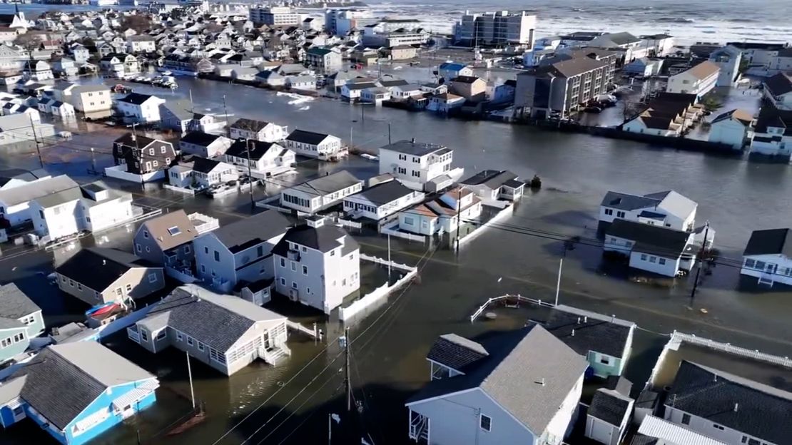
This is particularly the case in parts of coastal New England, where water levels skyrocketed to record highs early Wednesday morning from storm surge and heavy rain.
Unprecedented water levels inundated entire coastal towns, triggering significant flooding and forcing evacuations. Water levels are forecast to rival last storm’s in coastal Maine.
With little time to recede, the additional rainfall could send rivers surging once again. A few rivers in the Northeast and mid-Atlantic are forecast to hit major flood stage Saturday.
There will be some snow with this storm, just not on the coast. Snow with potentially some sleet mixed in will target elevated areas of the interior Northeast.
Along with the winter precipitation, strong winds will once again slam the Northeast and additional power outages are likely. The last storm knocked out power to hundreds of thousands of people in the East.
Snow will continue across the Great Lakes as well for a time Saturday, with lake-effect snow likely to develop in the wake of the storm late Saturday and continue into early next week.
The most significant impacts from the storm will generally exit the Southeast and mid-Atlantic by Saturday morning, but some breezy conditions will remain in the storm’s wake.
In the central US, brutal cold will only get worse throughout the weekend and into next week. Temperatures will reach dangerous levels, especially across the north-central US.
CNN’s Robert Shackelford, Taylor Ward and Joe Sutton contributed to this report.

