An eerily familiar situation will play out later this week as a new, powerful storm mirrors the path and hazards of the massive storm that slammed much of the country earlier this week.
Thousands of people are still without power in the eastern US, rivers are rising and forcing evacuations, and at least four people are dead from severe thunderstorms and wind as the first storm ended Wednesday.
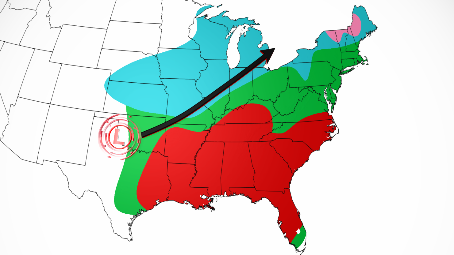
The new storm will place the same parts of the central and eastern US at risk once more – amplifying the potential impact for those still recovering.
The origins of the new storm are rooted in the Pacific Northwest, which was walloped by blizzard conditions on Tuesday.
Snow and blustery winds moved from the Northwest into the Four Corners region by late Wednesday. A round of snow will target the high elevations of Arizona and New Mexico through Thursday.
The storm will then morph into a much larger beast – its strengthening aided by a big push of atmospheric energy – as it exits the Plains by Thursday evening and sets the stage for a highly impactful event in the central and eastern US.
Here’s a breakdown of what to expect.
Thursday night: Snow for Plains, severe risk for South
The storm will strengthen Thursday night and begin to dump snow, which may be heavy at times, from parts of Kansas and Nebraska into the Midwest. This snow will be accompanied once again by gusty winds which may lead to whiteout conditions. Travel Thursday night may become treacherous.
Simultaneously, very cold air will plunge south out of Canada and send temperatures plummeting across much of the north-central US.
A severe thunderstorm threat will once again target a significant portion of the South. Parts of Arkansas, eastern Texas and northwestern Louisiana, including Shreveport, have an enhanced risk of severe storms, or a Level 3 of 5, on Thursday night, according to the Storm Prediction Center.
The main threats in those areas are strong tornadoes, large to very large hail and damaging wind gusts.
A slight risk for severe storms, or Level 2 of 5, is in place Thursday night for a wider area, from eastern Texas to western Mississippi. The main threats there are tornadoes, strong gusts and large hail.
Friday: Storm’s threats reach their peak
As the storm moves east on Friday and continues to become stronger, snow will envelop more of the Midwest.
The highest snow accumulations from this storm are expected to remain confined to portions of Michigan, Wisconsin and Illinois. Close to a foot of snow may fall in some inland portions of each state, away from the relative warmth of the Great Lakes.
Some uncertainty remains in exactly how much snow this storm delivers to Chicago. Its proximity to Lake Michigan could mean air temperatures are unable to drop low enough for a significant amount of snow. But, if the city gets trapped under a particularly heavy band of snow, much more could manage to stick and lead to significant travel issues.
Meanwhile, brutally cold air will continue to expand across more of the central and northern US. Air temperatures in Omaha, Nebraska, are unlikely to climb out of the single digits on Friday while parts of North Dakota will be lucky if high temperatures reach zero degrees.
On the southern, warm side of the storm, another significant severe thunderstorm event will target a large section of the Southeast and portions of the mid-Atlantic.
The greatest risk of damaging storms encompasses areas from Alabama to North Carolina. A Level 3 out of 5 risk of severe thunderstorms is in place for this area Friday and damaging wind gusts and a few strong tornadoes are possible.
Rain will overspread more of the mid-Atlantic and reach parts of the Northeast Friday night. Flooding concerns will increase from parts of Pennsylvania and New Jersey into Southern New England as the rain arrives.
Rainfall totals are expected to be about the same or slightly lower than the last storm: 1 to 2 inches are likely, but isolated locations could see closer to 3 inches. With the ground soaked and rivers still swollen from the last storm, flooding could happen much more easily.
Saturday: Power outage chances increase for Northeast
The storm will reach the Northeast by the earliest hours of Saturday morning, with snow and potentially some sleet mixed in across the interior Northeast, especially in northern New England.
Along with the winter precipitation, strong winds will once again slam the Northeast and additional power outages are likely. The last storm knocked out power to hundreds of thousands of people in the East, and many remain without power on Wednesday.
Snow will continue across the Great Lakes as well, with some lake-effect snow likely to develop in the wake of the storm late Saturday.
The most significant impacts from the storm will generally exit the Southeast and mid-Atlantic by Saturday morning, but some breezy conditions will remain in the storm’s wake.
In the central US, brutal cold will only get worse throughout the weekend and into next week. Temperatures will reach dangerous levels, especially across the north-central US.
CNN’s Robert Shackelford contributed to this report.

