When planning a trip to India, the “Golden Triangle,” comprising Delhi, Jaipur and Agra, often comes to mind as a must-see region. And these historic destinations do indeed provide a classic introduction to the country.
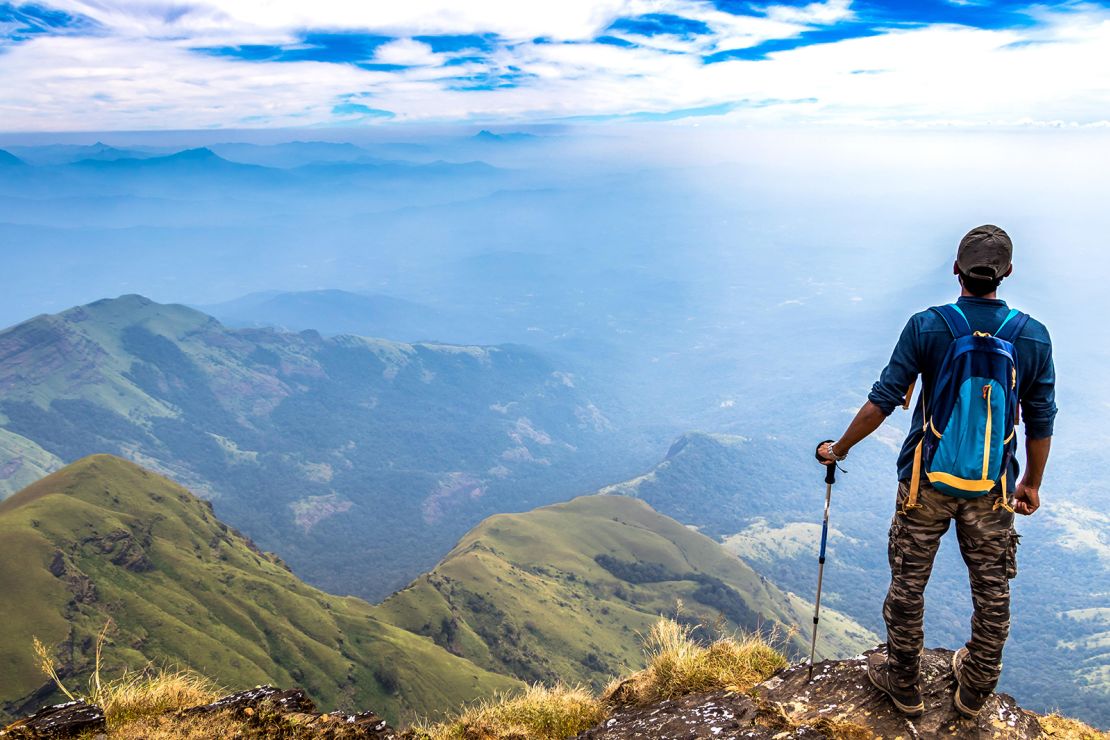
However, India boasts an array of natural wonders that provide ample opportunities for the more active traveler to get out and explore.
The terrain encountered during a hiking odyssey in subcontinent-sized India is as diverse as the cultural fabric that weaves this extraordinary nation together.
Here, one can encounter towering peaks of the formidable Himalayas and undulating plains that whisper tales of ancient civilization in the northern region. Towards the southern reaches, the forest-cloaked Western Ghats mountain range abounds with vibrant flora and fauna.
Numerous local guides and trekking agencies are on hand to help you conquer these trails. Check out the Indian Mountaineering Foundation for a list of the country’s registered tour agencies.
If it’s inspiration you’re after, here’s a rundown of 12 of the most epic hikes in India, ranging from quick, casual hikes to multi-day excursions.
Buran Ghati, Himachal Pradesh
Distance: 37 kilometers (30 miles)
Time: 7 days
Suitable for all levels, the Buran Ghati trek begins from the ancient hamlet of Janglik, about a five-hour drive from Shimla, the former summer capital during British colonial rule.
The terrain is never boring, as you pass through deep forest onto wide green meadows and across gurgling brooks under the shadow of snow-covered peaks, en route from the Daraya campsite to the Dunda campsite, enjoying views of glacial lakes like Chandranahan along the way.
Hikers will need to be well-acclimatized as the trail crosses a 4,572-meter (15,000-feet) pass on day five.
The true adventure lies in the descent from the pass on the other side, leading to the verdant Barau village, marking the culmination of this remarkable odyssey.
During summer (mid-May to June), a thrilling rappel of about 400 meters (1,312 feet) down a steep ice wall awaits, while in autumn (mid-September to mid-October), a steep descent amid rugged boulders provides an exhilarating experience.
Dzükou Valley, Nagaland
Distance: 9 kilometers (6 miles)
Time: 1 day
Straddling the borders of Manipur and Nagaland in the northeastern part of the country, Dzükou Valley is a giant green carpet that annually erupts into a riot of wildflowers, including the rare pink Dzukou Lily, which is only found here.
July is peak flower season, but the valley is gorgeous all summer.
There are two routes – most hikers start from Viswema Village, about 22 kilometers (14 miles) south of Nagaland’s capital city Kohima, while the trailhead at Zakhama Village, about 18 kilometers (11 miles) from Kohima, is shorter but the ascent is sharper.
The path climbs up rough-hewn stone steps and through a mix of chestnut, juniper, and oak thick forest, to reach the crest of the valley at 2,452 meters (8,045 feet) above sea level, where a riveting panorama unfolds.
It is possible to stay in the guesthouse run by the Southern Angami Youth Association (SAYO) in the valley, but the hike can also be completed as a day trip.
Indian nationals must acquire an Inner Line Permit (ILP) to visit Nagaland, while foreign visitors must register themselves at the local Foreigner Registration Office (FRO) within 24 hours of arrival.
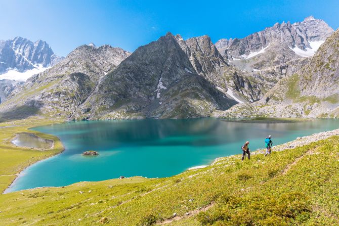
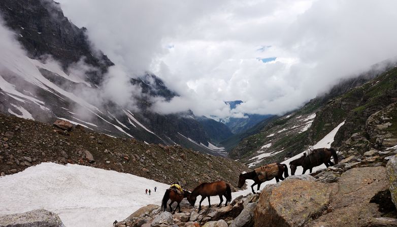
Great Lakes Trek, Indian-administered Kashmir

Distance: 63 kilometers (39 miles)
Time: 5 days
An absolute humdinger of a route, this trek takes in three high passes of the Himalayas and seven glacier-fed lakes.
Accessible from July through to September, the trail starts in the small hamlet of Shitkadi near Sonamarg, 80 kilometers (50 miles) northeast of the city of Srinagar and takes you over alpine meadows and grasslands before ending in the village of Naranag.
On day five comes the real treat – spectacular views of the biggest of the Satsar Lakes and the twin lakes of Gangabal and Nundkol.
While the hike isn’t particularly strenuous, you’ll need to spend a couple of days acclimatizing in Sonamarg beforehand to prepare yourself for the altitude of 4,200 meters (13,780 feet).
Trek Kashmir, a local travel agency, can arrange meals, camping equipment and transfers to and from Srinagar.
Goechala Trek, Sikkim
Distance: 73 kilometers (45 miles)
Time: 8 days
If you’re up for a challenge and view that ranks among India’s most sublime, consider this trek in West Sikkim.
The hike can be steep and tough, with 3,048 meters (10,000ft) of elevation gain and three suspension bridges over deep gorges to negotiate.
What really lodges this hike in your memory is the view of Kangchenjunga, the world’s third-highest peak, from Dzongri Top at 4,167 meters (13,670 feet).
The route also cuts through Khangchendzonga National Park, revered by the local Lepcha tribe.
Big wildlife rules here: red pandas, blue sheep, elusive snow leopards and blood pheasants can be found on this trail.
Starting and finishing in Yuksom Village, the trail is best hiked clockwise to acclimatize for the challenging ascents towards the end.
Numerous campsites and huts are spread along the trail, best completed during spring and fall months, i.e. April to May and September to November.
Markha Valley, Ladakh
Distance: 65 kilometers (40 miles)
Time: 6 days
Whisking you through wild landscapes within Hemis National Park, situated in the eastern region of Ladakh, the hugely popular Markha Valley epitomizes the extraordinary beauty of Indian nature.
The trail begins in the village of Chilling, about 66 kilometers (41 miles) from Ladakhi capital Leh and ends at Shang Sumdo, swinging from gentle to moderate in difficulty as the terrain changes.
There are barley fields and thickets to traverse, hanging bridges to cross and rocky canyons to negotiate.
Crossing the icy waters of Markha River (a tributary of the mighty Zanskar River), seeing the ancient Buddhist monasteries and 6,400-meter (21,000 feet) Kang Yatse and 6,153-meter (20,187 feet) Stok Kangri peaks, and climbing up to the 5,200-meter (17,060 feet) Kongmaru La Pass are moments you’ll rave about for the rest of your life.
There’s some wonderful wildlife too – blue sheep, Asiatic ibex, Himalayan marmot, Ladakhi urial and the endangered Eurasian brown bear all hang out in the park. Snow leopards make a rare appearance only during the winter months.
Nights spent camping under starlit skies or indulging in a warm meal at a village homestay along the way.
Acclimatize in Leh before embarking on this trek. July to September is the optimum period for hiking here.
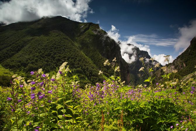
Valley of Flowers, Uttarakhand

Distance: 8 kilometers (5 miles) round trip
Time: 7 hours
A spectacular carpet of rare and exotic wildflowers is the trademark landscape on this dreamy hike, best tackled during the monsoon season (July to September).
There are a variety of trek distances available, but one of the most popular and shortest options begins and ends in Ghangaria, a popular base camp for visitors wanting to visit the valley.
Stay the night here for an early start in the valley, which opens its gates at 7 a.m., with trekkers being granted entry until 2 p.m.
Ascending and descending inclines while crossing the Pushpawati River, the route finally reaches the UNESCO World Heritage-listed Valley of Flowers, bedecked with over 500 species of flowers against a backdrop of glaciated mountains.
This protected area also serves as a habitat for Asiatic black bears, blue sheep and snow leopards, albeit sightings are rare.
As one of the most popular hikes in India, you won’t be alone, so there’s no need for a guide here.
Kudremukh Trek, Karnataka
Distance: 18 kilometers (11 miles)
Time: 4 hours
Nestled in the heart of Chikkamagaluru district in India’s Western Ghats, the 1,894-meter (6,214 feet) Kudremukh Peak is the third tallest summit in Karnataka state.
It’s an easy day hike to reach the summit, traversing through shola (virgin forest), small streams and rolling green hills.
Keep an eye out for endemic wildflowers and the occasional lion-tailed macaque, langur or Malabar giant squirrel.
Most hikers base themselves in the village of Mullodi, where one can purchase the requisite entry permit from the local forest office.
It pays to get an early start as trekking after 6 p.m. is prohibited, and only 50 hiking permits are issued per day.
It’s best to hike the trail during post-monsoon and winter months – September to February.
Namdapha Rainforest Trek, Arunachal Pradesh
Distance: 45 kilometers (28 miles)
Time: 6 days
For intrepid adventurers, exploring the rainforest wonderland that is Namdapha on foot is the epitome of off-the-beaten-path hiking.
Located in the eastern Himalayas, this out-and-back trek starts from Deban, a rough 26-kilometer (16-mile) drive from the petite town of Miao, where permits are issued at the Field Direction’s Office.
The trail crosses varying landscapes – small rivers, patches of forest and grassland and a short bit of gravelly terrain.
Birdwatchers will find themselves captivated by the five species of hornbills and other avian species found along the way.
The forest is also home to mammals such as the clouded leopard and Bengal tiger, though sightings are rare. Mischievous red pandas and gibbons can occasionally be spotted amidst the foliage as well.
Although lodging is available at the Forest Rest House in Deban, to make the absolute most of the path and visit the local tribes like Lisu and Tangsa who have inhabited the region for centuries it’s best to book the trek through a registered local tour operator.
The best time to hike here is mid-September to April.
Chembra Peak, Kerala

Distance: 4 kilometers (2.5 miles)
Time: 3 hours
The area around the mountainous Wayanad region in northeast Kerala, stretching along the Western Ghats, is home to several scenic walks.
A favorite among those looking for a tranquil and easy-to-moderate hike is Chembra Peak, perched at an elevation of 2,100 meters (6890 feet) above sea level.
The trail starts from the watchtower near the Chembra Peak VSS Forest Office – a short drive from the quaint hamlet of Meppadi – and winds its way through emerald tea plantations and wild grasslands.
While reaching the summit is prohibited, visitors can climb up to the heart-shaped lake, known locally as Hridaya Thadakam or Hridaya Saras, near the peak.
Best tackled between November and February, the trail is open from 7 a.m. to 5 p.m., and entry is limited to 200 hikers per day. Secure the permit from the forest office before 2 p.m.
Chatakpur-Tiger Hill, West Bengal
Distance: 14 kilometers (8.7 miles)
Time: 6 hours
A three-hour drive from Siliguri, Tiger Hill is a popular weekend destination for city dwellers so go during the week to avoid the crowds.
The trail to the summit of Tiger Hill starts in the town of Sonada in India’s Darjeeling district, passing through organic farmlands and orchards before reaching Chatakpur Village.
After overnighting there, continue uphill towards the watchtower, a mere 10 minutes from the village.
From the tower, the path leads to an enthralling expanse of Senchal Wildlife Sanctuary, home to a diverse array of Himalayan wildlife like black bears, barking deer and macaques, plus avian species like Blue Magpies and Old World Flycatchers.
The final leg involves an ascent to a creek, offering vistas of Tiger Hill’s green terraces.
At the summit, enjoy stunning panoramas of Darjeeling town below. And if the weather is clear, you can get magnificent views of the Kanchenjunga ranges.
Walk the route from October to April, when the weather is pleasant.
Hampta Pass, Himachal Pradesh

Distance: 25 kilometers (16 miles)
Time: 5 days
Forging a path between the verdant Kullu Valley and the barren, high-altitude deserts of Lahaul and Spiti, Hampta Pass – standing at 4,270 meters (14,010 feet) above sea level – delivers one stunning vista after another as it strides from Jobra, about two hours northeast of the hill resort of Manali, to Chhatru Settlement via wildflower-flecked Jwara Valley.
Highlights are many but you’ll never forget clapping eyes on the snow-capped peaks of Deo Tibba (6,001 meters/19,688 feet) and Mount Indrasan (6,221 meters/ 20,410 feet) from the top of Hampta Pass on day four.
Trekkers can camp en route at designated sites like Chika, Balu Ka Ghera and Shea Goru.
If you’d like to add a little extra adventure, continue north from Chhatru, the end-point of the Hampta Pass trek, to Spiti’s east-west highway and embark on a two-hour drive to the captivating Chandra Tal (‘Moon Lake’), perched at 4,250 meters (13,944 feet) above sea level.
Weather permitting, Hampta Pass is open to hikers from June to September.
Himalayan Yeti Adventure and Himalayan Caravan Adventure can take care of the logistics.
Nongriat Trek, Meghalaya
Distance: 7 kilometers (4.3 miles) round trip
Time: 1 day
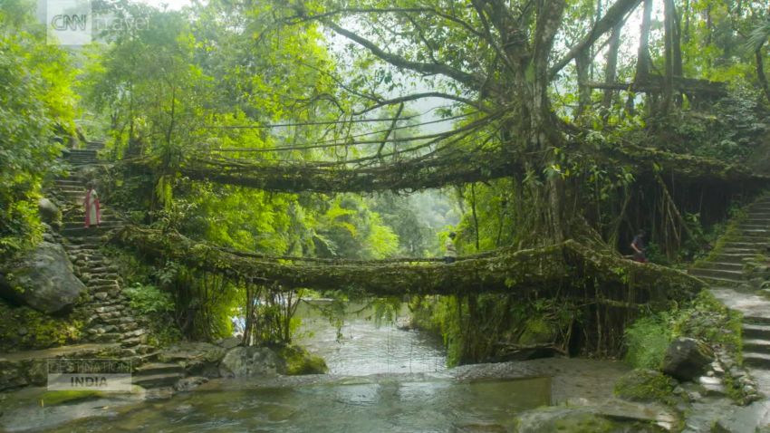
One of India’s most stirring natural wonders is the Living Root Bridges, crafted by indigenous Khasi villagers out of Indian rubber tree roots.
Over 100 of these humble river crossings are found in the Meghalaya hills, with a notable concentration in the jungle-laden Nongriat Village.
Accessible from Tyrna village, 12 kilometers (7.5 miles) southwest of Cherrapunji – one of the wettest places in the world – the hike begins with a descent of more than 3,000 stone steps before venturing into the dense rainforest, which is alive with butterflies and insects. The finale is the centuries-old double-decker living root bridge.
Logistics are easy for the Nongriat hike - there are many drink and snack stalls en route.
While guides are not obligatory, they’ll help you get acquainted with the local communities.
Hike between April to June, as the weather is comfortably warm. But do bring a rain jacket and sturdy, waterproof shoes, as conditions can change at the drop of a hat.

