

Warmth is set to thaw parts of the United States following frigid weekend temperatures – but the warmer air will bring a risk of ice and flooding for some states, and another crippling winter storm is set to hit portions of the Plains and South into Monday.
A series of winter storms this month have killed at least 82 people in 13 states. The death toll climbed on Sunday after emergency management agencies in Oregon, Mississippi and Tennessee reported additional weather-related fatalities.
Now a series of fronts and low-pressure systems are working together to bring warmer air and tropical moisture into the eastern half of the US this week.
The arctic chill will be ending, and cities will begin warming up, with some seeing daily high temperatures increase by close to 30 degrees over the course of three or four days.
Temperatures will be significantly above average by the end of the week, with highs Thursday reaching the upper 60s to low 70s throughout the Southeast and temperatures in the 50s as far north as New York.
Overnight lows will soar into the 60s for parts of the Southeast, potentially breaking over 100 records for warmest daily lows.
This warmer air will finally chase out the arctic blast that his been dominating the majority of the country’s weather this weekend, but will bring several potential hazards, including ice and flooding.
Ice, freezing rain to chill swath of central US
As moisture from the Gulf of Mexico is pushed northward Sunday into Monday, it will collide with cold air still lingering over portions of the central US to create ice and freezing rain in a wide swath from Dallas almost as far north as Fort Wayne, Indiana.
“Meanwhile, the presence of arctic air farther north will support mixed precipitation, sleet and ice as the moisture reaches into Oklahoma and Kansas tonight,” the Weather Prediction Center said.
Multiple state transportation offices urged travelers to stay off the roads.
“Freezing rain is expected across most of the state overnight through Monday creating potentially icy conditions. Please avoid travel if possible or delay your trip,” the Missouri Department of Transportation said Sunday afternoon in a post on X, formerly Twitter.
In Arkansas, transportation officials warned Monday’s commute would be severely impacted as a result of freezing rain late Sunday evening into the start of the work week.
The National Weather Service issued an ice storm warning for parts of Arkansas and Oklahoma. A winter storm warning is also in effect for some areas of Oklahoma.
Weather service forecasters in Tulsa warned of “significant icing,” – between a quarter to a half-inch of ice accumulation – along with 15 to 20 mph sustained wind speeds and higher gusts.
“Scattered to numerous power outages may result from the combination of ice accumulation and wind,” Tulsa’s weather service office said in a forecast message.
The majority of the regions facing an icy forecast are likely to receive less than a quarter of an inch of ice by Monday evening, but up to half an inch of ice is in the forecast for northern Arkansas and southern Missouri, according to the National Weather Service.
Icy weather will shift to rain, flood threat
As the warm air continues its northward trajectory, freezing rain and icy precipitation will transition to rain, bringing the threat of flooding.
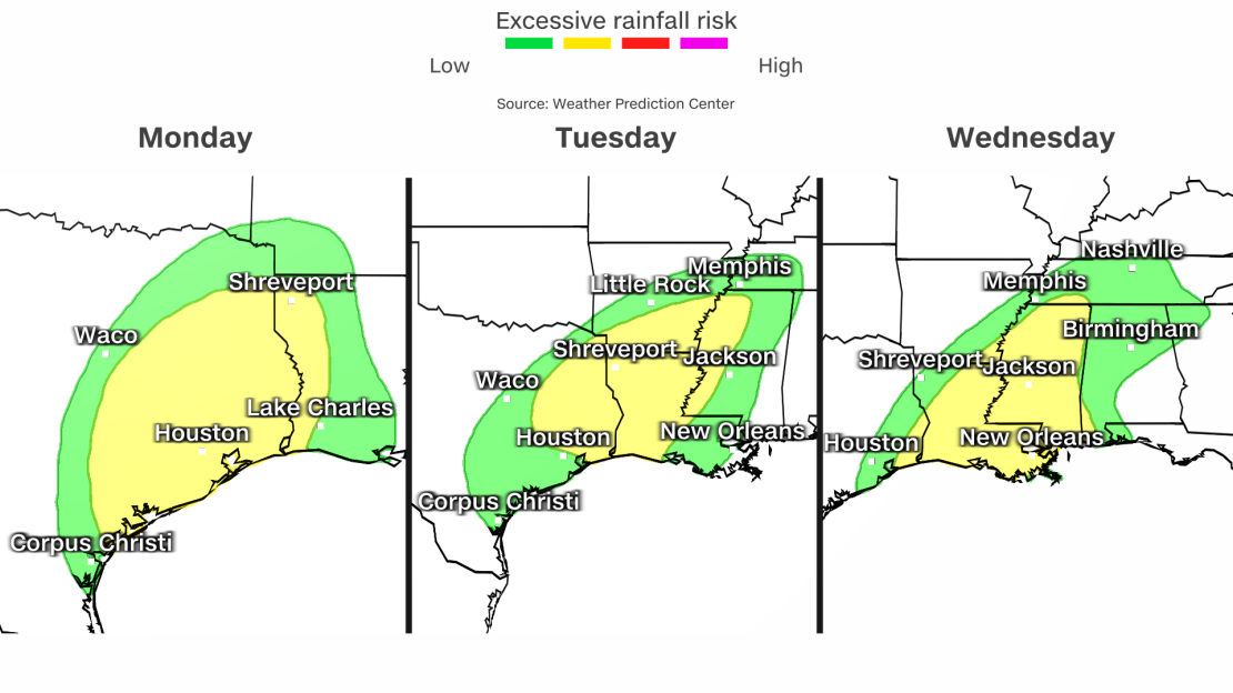
Approximately 37 million people are under threat of flash flooding and excessive rainfall this week from Monday to Thursday morning along the Gulf Coast and in the western portions of the Southeast.
There is a Level 2 of 4 risk of excessive rainfall and flash flooding moving eastward throughout the week:
• Monday – eastern Texas
• Tuesday – Lower Mississippi River Valley
• Wednesday – Louisiana, Alabama and Tennessee
• Thursday to Friday morning – Gulf coast of Mississippi and Alabama into Tennessee
Some areas will be under a Level 2 risk of excessive rainfall for several days in a row.
Rainfall totals over the next five days may reach 5 to 6 inches with localized areas getting higher amounts.
The regions most impacted by the heavy rain are also slightly at risk of developing severe weather, the Lake Charles, Louisiana, the weather service office said.

