Rain, wind and snow may deal a blow to holiday cheer for some travelers in the central US this weekend, with disruptions possible on the ground and in the air.
The 10-day holiday travel period starting Saturday is likely to be the busiest ever at US airports, according to AAA’s year-end holiday forecast. All told, 115 million Americans are expected to travel at least 50 miles from home this holiday season. Here’s what many of them can expect.
Friday: Tricky travel across the West
The West is the not-so-lucky recipient of two simultaneous storms Friday – one in the Southwest and one in the Northwest – and is the region of the US most likely to deal with disrupted travel.
The same storm that unloaded gushing rainfall and flooded portions of Southern California on Thursday will expand into the Southwest on Friday. Periods of heavy rainfall will increase flooding concerns across Arizona on Friday and portions of New Mexico by Friday evening.
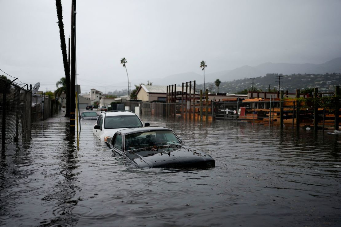
Additional flooding is possible across Southern California on Friday as rain persists.
A Level 2 out of 4 risk of excessive rainfall is in place Friday for Southern California and much of southern Arizona, according to the Weather Prediction Center.

Farther north, a storm that arrived in the Pacific Northwest early Friday morning will track across the Northwest during the day and push into the Rocky Mountains later Friday evening.
More than half a foot of snow is likely on Friday in parts of Washington’s Cascade Mountains. This includes the popular Stevens Pass that cuts through the Cascades, which could bring travel to a standstill for drivers without proper snow chains. Rain will fall at lower elevations across the Northwest.
Elsewhere, conditions will be dry and largely calm for travelers across the East on Friday. Some rain will stretch from the southern Plains into the Midwest from Friday into Saturday, but heavy, flooding rainfall is unlikely.
Saturday and Sunday: Stormy, but record warm for some
The two disruptive storms trekking across the West on Friday will combine to form one larger storm over the Rockies on Saturday and impact the central US on Sunday. Travel concerns will ramp up Saturday as accumulating snow falls from Idaho and Montana through Colorado and New Mexico.
Anyone driving to see loved ones in the Rockies on Saturday should prepare for a potentially long and snowy trip. Snow will continue across Wyoming and Colorado on Sunday and expand into Nebraska and the Dakotas as the storm pushes into the central US.
It’ll take until Saturday night for a mix of rain and snow to arrive in Denver, before changing fully over to snow on Sunday. This snow could turn into quite the headache for last-minute air travelers, especially those headed through Denver International Airport, the busiest hub in the region.
Far removed from the snow, rain will stretch from the southern Plains and Lower Mississippi Valley to the Midwest on Sunday as the storm expands its reach.
This rain could be heavy at times, especially for areas closer to the Gulf Coast. A Level 2 out of 4 risk of excessive rainfall is forecast Sunday for more than nine million people across much of Louisiana and portions of Mississippi, Texas and Arkansas.
Wet roadways and heavy traffic on Christmas Eve will likely lead to very slow-going travel in metro areas like Dallas and Kansas City. In places like New Orleans where the rain is heaviest, any flooded roadways will bring travel to a halt.
Wind speeds will also pick up across the central US on Sunday, and in many places it’ll be breezy with a few stronger wind gusts possible. Flight delays are possible wherever these stronger wind gusts become more frequent.
Typically, a large storm in the central US on Christmas Eve would mean snow for a much more expansive swath of the region – but this year is different.
Very mild and potentially record-breaking temperatures are set to develop across the region due in part to the influence of El Niño, a natural ocean and weather pattern in the tropical Pacific that influences weather around the globe.
Daily high temperature records are in jeopardy across the Upper Midwest on Saturday and across more of the Midwest and Plains on Christmas Eve. Record warmth will likely extend to Christmas Day in the Midwest.
Christmas Day: Wet and mild, not white
The weekend storm will push east on Monday and usher in a mild, soggy Christmas day from the Midwest to the Southeast.
Like Sunday, the heaviest rain that could lead to flooding will remain confined to areas near the Gulf Coast on Monday. Rain farther north will be steady at times, but is unlikely to lead to significant flooding concerns.
In one of the only cold spots of the storm left by Monday, snow will continue across parts of Nebraska and an icy mix of rain, snow and sleet may impact portions of Iowa, Minnesota and Wisconsin.
Elsewhere, a dry Christmas Day is in store for a vast majority of the West and the Northeast.
To add insult to injury for those whose dreams of a white Christmas have been dashed, this Christmas could set another lackluster snow record.
Only 13.2% of mainland US had snow on the ground, known as snow cover, as of Friday morning, according to NOAA. Most of this snow cover is in the Rockies and Cascades, with some in the high terrain of the Northeast.
Snowfall across the Rockies this weekend will likely help raise the overall snow coverage percentage slightly. But it may not be enough to prevent this year from having some of the least Christmas snow cover since 2003 when 21.2% of the US had snow on the ground.

