A wide-reaching storm is set to affect much of the eastern half of the US this weekend with heavy rain, severe thunderstorms, strong winds and even snow.
The weekend storm will begin to take shape on Friday as an area of low pressure develops in the southern Plains. Energy left over from a deadly atmospheric river in the Northwest earlier this week will arrive in the central US and boost the strength of the developing storm.
Any impactful weather from the storm will hold off until late Friday when it gets better organized and tracks out of the southern Plains and into the Midwest.
From there, the storm’s impact will grow substantially, with heavy rain, thunderstorms and gusty winds reaching the entire East throughout the weekend.
Saturday: Severe storms fire up
As the storm strengthens and expands its reach on Saturday, adverse weather will stretch more than 1,200 miles from the Gulf Coast to the Canadian border.
Thunderstorms will rumble to life Friday night with a small window in which isolated severe thunderstorms could develop in parts of Oklahoma, Arkansas and Texas, ahead of Saturday’s threat to the south.
The main thunderstorm event will kick off across portions of the South by Saturday morning as a cold front associated with the storm cuts east across the region. Some of these thunderstorms could become severe and deliver damaging wind gusts and hail. A slight risk, or Level 2 of 5, for severe thunderstorms is forecast for portions of Texas, Louisiana, Arkansas and Mississippi, especially by Saturday afternoon.
As chances for damaging thunderstorms increase Saturday afternoon, the storm will also spread rain across a wide portion of the country from the Gulf Coast to the Midwest. Rain will begin in the earliest hours of Saturday across portions of the Midwest and Mississippi Valley and spread east throughout the day.
Rain will become steady as the day progresses and could become heavy at times, especially across the South. Fortunately, the storm is likely to move along at a brisk pace that will keep rainfall totals from skyrocketing, but any drenching rainfall could cause flooding issues.
Gusty winds will also accompany any rainfall, even outside of thunderstorms.
A thin stripe of accumulating snow is possible on Saturday from Wisconsin to Michigan’s Upper Peninsula, but this will be mostly a rain event for much of the Midwest.
Sunday: Strong wind event takes shape
The storm will reach its maximum strength by the afternoon as it expands and engulfs much of the East. Wind gusts from the storm will be quite a bit stronger on Sunday compared to Saturday and could knock out power and disrupt travel.
Widespread gusts of 40 to 50 mph will buffet the mid-Atlantic and Northeast. Gusts will crank even higher and reach up to 60 mph at times Sunday night in New England and coastal portions of New York and New Jersey.
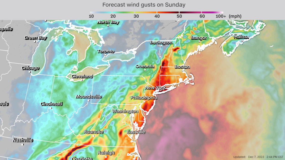
Winds this strong, especially when coupled with drenching rain, could bring down a few trees and cause power outages. Strong winds and rain may also disrupt air travel across the busy corridor and lead to slowdowns for drivers.
Any unsecured outdoor holiday decorations may be blown away by the strongest winds.
Rain will be the primary precipitation type from Florida to New England, with widespread amounts of 1 to 2 inches likely. Higher totals are possible for areas drenched by multiple rounds of downpours.
Some thunderstorms will be embedded within the rainy area, even in the North. A few thunderstorms may become severe on Sunday, with an area from Georgia to Virginia the most likely to endure a handful of damaging storms.
Rain may change to wet snow across higher elevations in West Virginia, Pennsylvania and New York on Sunday night as cold air pushes into the East on the backside of the storm.
Portions of New England could change over to a wintry mix of rain, snow and freezing rain late Sunday night and continue for a time on Monday.
Exact changeover times and snow amounts will depend on how quickly cold air can rush into the region.
Monday: Cold envelops the East
The storm will start to push off the East Coast on Monday, but rain and snow will continue across much of New England and parts of upstate New York through the afternoon before tapering off in the evening. Rainy, windy weather will come to an end in New York City by Monday afternoon while gusty winds slowly subside elsewhere in the Northeast, except for in New England.
It’ll be much chillier on Monday across the eastern half of the country in the wake of the storm. The difference in temperature between Monday and the weekend’s above average December temperatures will be most stark from the Southeast to Northeast.

