Another severe thunderstorm threat, including the possibility of tornadoes, will take aim at the southern United States on Thursday, less than two weeks after at least a dozen tornadoes hit Louisiana and Mississippi.
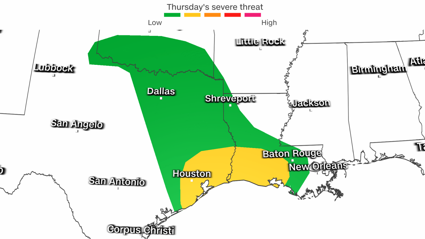
Damaging storms that may spin up a few tornadoes are possible from coastal Texas into south-central Louisiana on Thursday afternoon, as a storm system takes shape in the southern Plains.
Get Up To Speed:
- Happening Now: Thunderstorms continue to develop across much of eastern Texas
- Primary threats: Tornadoes and damaging wind gusts in Texas and southern Louisiana
- Area of most concern: Coastal Texas through south-central Louisiana, including Houston
- Timing for the area of most concern: Through 5 p.m. in Texas; through 8 p.m. in Louisiana
- One more thing: The same storm system will also deliver much-needed rain to the nation’s worst-hit drought areas in the Mississippi Valley
Confidence in an active tornado day dropped slightly late Thursday morning as some atmospheric ingredients needed to produce dangerous storms had yet to click into place. A thick layer of clouds over much of southern and eastern Texas cut off the heat fuel needed for feisty storm development early Thursday.
Tornadoes are still possible from coastal Texas – including the Houston metro area – through south-central Louisiana Thursday afternoon. A slight risk, or Level 2 of 5, for severe storms is in place for the area on Thursday, according to the Storm Prediction Center.
In addition to tornadoes, any severe thunderstorm on Thursday could produce hail, damaging wind gusts up to 60 mph and heavy rainfall.
The severe storm threat will linger into Thursday night in Louisiana as the storm system begins to track generally from the Plains into the Mississippi Valley.
Rain will fall across an expansive part of the Mississippi Valley, Midwest and Southeast as the storm pushes north and eastward Thursday night into Friday.
This rain is desperately needed in the Lower Mississippi Valley, especially in Louisiana and Mississippi, which are battling some of the worst drought in the US.
Louisiana is suffering through its worst drought on record – one which has fed unprecedented wildfires. Exceptional drought – the US Drought Monitor’s highest level – covers 70% of the state, according to data released Thursday. Exceptional drought covers a third of Mississippi.
One to 3 inches of rain is expected to fall across the Mississippi Valley on Thursday, and an additional 1 to 2 inches could fall Friday in portions of the Gulf Coast and Southeast.
Additional severe thunderstorms are possible, but much less likely, on Friday from Louisiana to Alabama and the Florida Panhandle. A marginal risk level for severe storms, or a Level 1 out of 5, is in place for the area on Friday.
November marks the start of a secondary severe weather season in the South. The clash between cold, Canadian air drilling into the region and lingering warm, moist air over the Gulf of Mexico typically leads to an uptick in damaging thunderstorms from November to December.


