


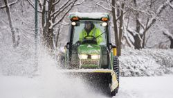


A winter storm moving across the Northeast has dropped 1.8 inches of snow on New York’s Central Park, marking the biggest snowfall of the season for the city in what has been an unusually warm winter.
The snow measurement at 7 a.m. Tuesday brings the total for this winter to 2.2 inches – the lowest seasonal snowfall on record and more than 2 feet below the seasonal average of 29.8 inches.
The system was moving out of the New York City area Tuesday but continuing to deliver snowy conditions in upstate New York and New England.

Boston, which is also experiencing below-average snowfall, had picked up about 0.8 inches as of Tuesday morning. The city, which is used to measuring snow events by the foot, has seen just 11.5 inches so far this season, the fourth-lowest amount on record and more than 3 feet below its average seasonal snowfall of 49.2 inches.
The unusually snowless winter prompted Mayor Gary Christenson of Malden, Massachusetts, just north of Boston, to declare winter over on February 8, when he tweeted the city was lifting all winter parking restrictions for its roughly 65,000 residents.
“This year, winter parking rules began on February 1st but were quickly removed due to a warmer-than-average weather pattern in February,” the city announced on its website.
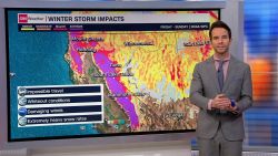
Winter weather expected across the Northeast through midweek
Winter weather alerts, which include both winter storm warnings and winter weather advisories, are in effect for parts of central Pennsylvania through central Maine through Tuesday, according to the weather service. The highest snow amounts are expected across interior portions of New York, Connecticut and into the Berkshire mountains in Massachusetts, where up to a foot of fresh powder is possible.
Mixed precipitation is expected in parts of central Pennsylvania, including 1 to 2 inches of snow and sleet in the valleys and 2 to 4 inches on higher ground; ice accumulation is also expected. Parts of central and upstate New York could see 2 to 5 inches of snow and up to a quarter inch of ice.
“Plan on slippery road conditions. The hazardous conditions could impact the morning or evening commute,” the weather service warned.
The threat of snow and ice moves into New Hampshire and Maine starting Tuesday morning through Wednesday morning.
Drought isn’t a concern
Despite the minimal snow this season, the Northeast is not under threat of drought, and if anything, the situation is improving.
“Essentially, the snow drought is not equaling an actual drought for the Northeast,” said CNN meteorologist Brandon Miller, who added the region is experiencing the normal number of storms and amounts of precipitation, it’s just falling as rain, rather than snow, due to the warm temperatures.
Weather Prediction Center Branch Chief Greg Carbin told CNN in January “the East is certainly in a snow drought with some locations that normally have snow, down by as much as 1 to more than 3 feet.”
The period between snow events is also likely to increase as the climate warms, and it may be especially true for coastal Northeastern cities. As the Northeast temperatures warm, the rain-snow line shifts farther north, leading to more rainy winter days along the coast and less snow, according to the US National Climate Assessment.
And it’s not just the Northeast. Meteorological winter, which spans December, January, and February, is also the fastest-warming season for 75% of 238 US locations, according to Climate Central’s data analysis.
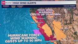
While much of the Northeast, with the exception of western New York, has had nearly no snow this winter, the western US is a different story as feet of snow blanketed parts of Southern California over the weekend, with blizzard warnings and winter storm warnings in effect again Tuesday.
CNN’s Brandon Miller and Haley Brink contributed to this report.

