
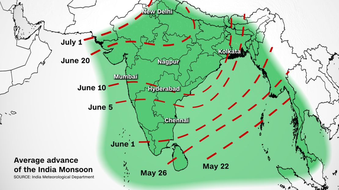
The India Meteorological Department (IMD) has officially declared the onset of the monsoon over the state of Kerala. The monsoon, which usually starts on June 1, is a few days late. But while the onset date is important, the overall forecast is much more crucial.
“Southwest monsoon seasonal rainfall over the country as a whole is most likely to be normal,” the IMD said in a press release. “Quantitatively, the monsoon seasonal rainfall over the country as a whole is likely to be 101% of the Long Period Average with a model error of plus or minus 4 percent.”
The Indian weather agency classifies a monsoon as normal when total rainfall from June through September falls within the range of 96% to 104% of average. From 1961 to 2010, that long period average equates out to 88 cm total, or 34 inches.
This means that we could see the first monsoon season in five years with measurements in the normal range. Both 2019 and 2020 were excessively high at 110% and 109% of the average, respectively. In fact, the monsoon in 2019 and 2020 rank as the second and third wettest seasons since 1990. It also marked the first time back-to-back rainy seasons had this large of a rainfall surplus since the 1950s.
Totals between 104% and 110% of normal are considered “excess,” while anything above 110% is designated as “large excess.” Since monsoon records began in 1988, only the seasons of 1988, 1994 and 2019 were wetter than 2020.
In 2017 and 2018, the opposite happened. The seasonal totals were both deficits in those years, with -5% and -9% respectively. The last year with normal results was 2016 when there was only a deficit of 3%, which falls within the normal range of plus or minus 4 percent.

Not all areas are equal
In order for the IMD to declare the onset of the monsoon over Kerala, the following criteria need to be fulfilled:
- More than 60% of the 14 rainfall monitoring stations report rainfall of 2.5 mm or more during the past 2 days consecutively, along with a fairly widespread spatial distribution over the region
Westerly winds have strengthened in the lower levels (wind speed up to 20 knots) and Satellite derived winds suggest that 15-20 knot westerly winds prevail up to 600 hPa. There is persistent convection (cloudiness indicated by outgoing longwave radiation values <200 Wm-2) from satellite imagery and coastal Doppler weather radar over Lakshadweep and adjoining southeast Arabian Sea, off the Kerala coast and the Maldives area.

Nonetheless, rainfall is not evenly spread throughout the whole country. Despite indications of a normal season, some areas will see portions of drought, and others extreme flooding, regardless.
” T h e s o u t h w e s t m o n s o o n s e a s o n a l ( J u n e t o S e p t e m b e r ) r a i n f a l l o v e r t h e f o u r h o m o g e n e o u s r a i n f a l l i s m o s t l i k e l y t o b e N o r m a l o v e r N o r t h w e s t I n d i a ( 9 2 - 1 0 8 % ) a n d S o u t h P e n i n s u l a ( 9 3 - 1 0 7 % ) . S e a s o n a l r a i n f a l l i s m o s t l i k e l y t o b e b e l o w n o r m a l o v e r N o r t h e a s t I n d i a ( 1 0 6 % ) . ” t h e I n d i a M e t e o r o l o g i c a l D e p a r t m e n t s a i d i n a p r e s s r e l e a s e .
The IMD will also be watching closely sea surface temperatures.
“Conditions over the Pacific and the Indian Oceans are known to have a strong influence on Indian monsoon,” IMD cautioned on its website.
Last year, there was a strong La Nina present, and that contributed to the higher than normal rainfall amounts. This year, neither La Nina or El Nino are expected, but rather “neutral conditions” are forecast. If this forecast changes, however, the amount of monsoon rains may also fluctuate near the end of the monsoon season.
CNN meteorologist Taylor Ward contributed to this story.

