


Editor’s Note: CNN’s continuing coverage of Tropical Storm Ophelia and Saturday’s impacts can be found here.
Tropical Storm Ophelia has strengthened off the East Coast, Hurricane Hunter data shows, as North Carolina and parts of the mid-Atlantic prepare for a soggy and windy weekend ahead of the storm’s anticipated landfall.
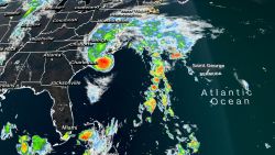
The storm, packing maximum sustained winds of 70 mph with higher gusts, is expected to affect areas hundreds of miles beyond its center with several inches of rain as it treks up the coast, according to the National Hurricane Center.
A hurricane watch was issued for portions of eastern North Carolina, where water levels were rising along parts of the coast Friday night. Ophelia moved north-northwest toward the East Coast on Friday at 12 mph.
The storm’s center is forecast to approach North Carolina’s coast Friday night, the National Hurricane Center stated in an update.
“Some additional strengthening cannot be ruled out as Ophelia traverses the warm waters of the Gulf Stream on its approach to eastern North Carolina. While this does not seem like the most likely outcome and is not explicitly forecast, the increased risk warrants the issuance of a Hurricane Watch for a portion of the North Carolina coast,” the hurricane center said.
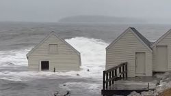
Coastal areas will bear the brunt of the heaviest rains and wind, though inland residents will get storms, too. Ophelia is targeting a landfall in North Carolina Saturday, but by the time the storm’s journey is done, wind and rain will have reached as far north as southern New England.
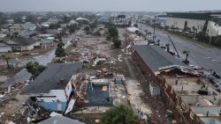
Ophelia’s strong winds could knock out power in some places, especially along the coast. North Carolina Gov. Roy Cooper ordered a state of emergency for the entire state Friday as the storm was already lashing coastal areas. The order will help make it easier for emergency crews to respond to the storm.
The heavy rain and wind affecting North Carolina and Virginia will worsen into the evening Friday and affect more areas as the storm approaches the coast, so tropical storm warnings stretch from just south of Charleston, South Carolina, to around the Maryland-Delaware state line. Storm surge watches and warnings stretch from Surf City, North Carolina, to the Chesapeake Bay.
A few tornadoes are also possible in parts of the coastal mid-Atlantic.
The greatest risk of heavy rain and flooding Friday into Saturday was expected in eastern North Carolina and southeast Virginia, where 3 to 5 inches are forecast. Areas where strong bands of thunderstorms develop could see as much as 7 inches of rain.
A broad stretch of the mid-Atlantic into southern New England could see 2 to 4 inches of rainfall from late Friday through the weekend.
Areas along the coast could also see hazardous storm surge and coastal flooding, strong rip currents and rough surf. One to 5 feet of surge is possible in some areas, particularly in inlets and rivers from around Surf City, North Carolina, to Manasquan Inlet on the New Jersey shore.
The highest risk of storm surge flooding will coincide with Saturday high tides, particularly in a coastal area from New Jersey to the Virginia Tidewater.
More than two dozen flood gauges across the area were forecast to hit moderate or major flood levels Saturday, which means homes and businesses closest to the coast could flood and roads could become impassable.
CNN’s Mary Gilbert, Sara Tonks and Ashley R. Williams contributed to this report.

