Record-breaking warmth will open the door Tuesday for a round of unusual February severe thunderstorms and potential tornadoes in the Midwest as dramatically different air masses clash.
These kinds of storms – which can generate tornadoes, large hail and damaging winds – are possible at any point in the year if the atmospheric conditions are right. But they typically become more frequent starting in the spring – May to July in the same parts of the Midwest and Great Lakes at risk Tuesday – as warmer temperatures take hold.
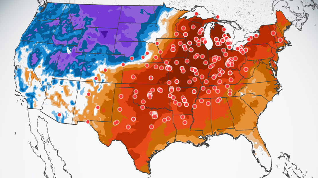
The risk of severe storms was increased from a Level 2 of 5 to a Level 3 of 5 in these regions by the Storm Prediction Center as confidence grew in a potentially impactful severe storm event.
The storms will rumble to life as a large portion of the US is strapped into a temperature roller coaster with notable rises and falls through the weekend.
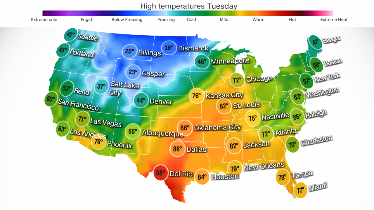
Dozens of daily and monthly records were shattered in the central US Monday as temperatures soared to springlike levels. At least 200 more records are in jeopardy through Wednesday over the eastern two-thirds of the US.
The extreme warmth caps what has been one of the warmest winters on record for many from the Midwest to the Northeast and is emblematic of the kind of winters scientists expect more often as global temperatures rise because of human-caused climate change. Winter has become the fastest-warming season for nearly 75% of the US.
The heat from this week’s event is being steered by a northward bulge in the jet stream – a river of air in the upper atmosphere that acts as a divider between warm and cold – over the central US. It’s allowing warmer, humid air to surge north from the Gulf of Mexico.
The warm, moist air is two of the three ingredients needed to create thunderstorms. A potent cold front associated with a storm tracking into the Midwest will serve as the third ingredient and ignite the severe thunderstorms on Tuesday.
Damaging wind gusts, large hail and a few tornadoes are the main risks associated with severe storms, but Tuesday could also have “a strong tornado or two,” the Storm Prediction Center said. Strong tornadoes are EF2-plus with winds greater than 111 mph.
A Level 3 of 5 risk for severe storms is in place for parts of Illinois, Wisconsin, Missouri, Indiana, Ohio and Kentucky. Within this area, far southern Illinois, southern Indiana and parts of northern Kentucky are most at risk for tornadoes.
Other parts of the Midwest and Great Lakes are under a Level 2 of 5 risk for severe storms. Chicago, Detroit, Cleveland and Indianapolis could all face damaging thunderstorms.
Disruptive thunderstorms look to hold off until the evening across southern Michigan, allowing many voters to stay dry at the polls for the Presidential primary Tuesday.
Chicago’s greatest risk for strong thunderstorms and possible tornadoes will occur Tuesday evening.
The risk for severe thunderstorms will decrease by Wednesday as the storm spreads into the East. Rain with a few embedded thunderstorms could soak much of the East Wednesday while temperatures plummet over the central US in the cold front’s wake.
Topsy-turvy temperatures
Temperature records were shattered in the central US Monday as the thermometer reached triple digits for the first time this year.
Dallas sizzled as the high topped out at 94 degrees: smashing the daily record and falling just shy of the all-time February high. Killeen, Texas, reached 100 degrees.

Minneapolis recorded its warmest-ever February day. Chicago smashed its daily high temperature record as it climbed to 71 degrees.
The extreme heat spreads east on Tuesday. High temperatures climb 20 to 30 degrees above average from the southern Plains through the Great Lakes. Additional monthly records could be in jeopardy, especially in the Midwest and Great Lakes.

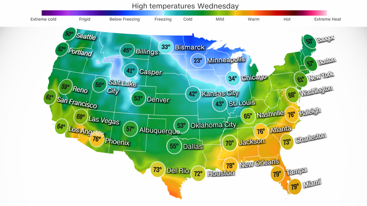
High temperatures come crashing right back down for much of the region Wednesday.
Temperatures could drop 30 to 40 degrees in just 24 hours in the central US.
The cold will arrive so abruptly that Tuesday’s stormy weather may end as a bit of wintry mix or snow early Wednesday morning in Chicago.
Chicago is forecast to reach the 70s again on Tuesday before plummeting to a high in the 20s Wednesday.
Low temperatures in Minneapolis are forecast to plunge into the single digits by early Wednesday morning.
Wednesday will likely be the warmest day of the week for the East Coast before the potent cold front arrives and topples temperatures Thursday.
And the weather whiplash won’t stop. The blast of chill will be short-lived as temperatures in the central US climb close to springlike levels again by Friday and much of the East by Saturday.
Above-average warmth is likely to persist through early March over the eastern half of the US, according to the Climate Prediction Center.

