
An already fledgling winter is on borrowed time for much of the country as a dramatic pattern change next week and temperature forecasts into March signal what could be the final nail in the coffin of a winter like no other.
Unseasonable warmth, missing snow and disappearing ice have blurred the line between winter and spring for a large portion of the US. Nowhere has this been more the case than in the central and eastern US. Despite a brief but significant outbreak of Arctic air in mid-January and a few chilly days last week, mild conditions have been the norm.
The warmth is about to ratchet up a notch next week. An area stretching from Dallas north to Minneapolis and east to Philadelphia will soar to levels more akin to May or June than the end of February.
More than 200 daily temperature records could be tied or broken as daytime highs climb and overnight lows fail to cool off.
The significant warming trend kicks off Sunday in the central US and become more intense by Monday. A northward shift in the jet stream will allow very warm air to rush north from the Gulf of Mexico and reach the Canadian border.
Monday will likely be the warmest day of the year so far for cities including St. Louis, Dallas and Chicago. That will also notably be the case in typically-cold parts of the central US. High temperatures there could be as much as 30 degrees above normal.
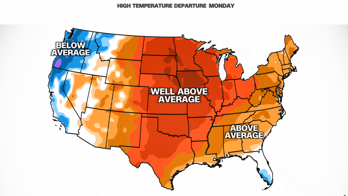
Omaha, Nebraska, is forecast to climb into the 70s on Monday. The city should normally top out around 40 degrees at the end of February and typically doesn’t record its first 70 degree temperature until late March.
Dallas may flirt with the 90-degree mark on Monday – a threshold that isn’t typically eclipsed until late April. Triple-digit temperatures are possible for parts of Texas near the Mexico border.
The core of the unseasonable warmth spreads east on Tuesday to encompass much of the Great Lakes and Ohio Valley. High temperatures in the 60s are likely from Chicago to Cleveland, while St. Louis could approach 80 degrees.
And there won’t be any relief for Texas with highs in the 80s and 90s likely.

Warmth reaches the East Coast by Wednesday. Philadelphia and New York City could top out in the 60s. The Gulf Coast and the Southeast will continue to sizzle.
With spring-like warmth comes spring-like weather. A storm forecast to develop near the Great Lakes late Tuesday could unload rain and thunderstorms on much of the East into Thursday.
The clash of warm, moist air with the storm’s potent cold front could set the stage in parts of the Plains and Midwest for some severe thunderstorms late Tuesday. The same threat could carry on east into parts of the Southeast and Ohio Valley Wednesday.
A quick flip back to a more-seasonable chill is likely in the north-central US Tuesday and Wednesday behind the cold front. But the brief burst of cold is likely too little too late to resurrect a largely nonexistent winter, which officially ends in March.
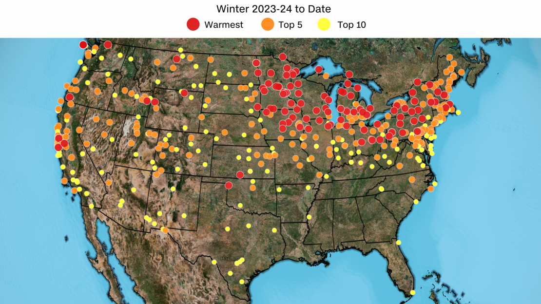
This winter is on pace to become one of the warmest on record in dozens of US cities, with the highest concentration in the Midwest and Northeast.
Warmth and winter weather do not get along. Winter has become the fastest-warming season for nearly 75% of the US and snowfall is declining around the globe as temperatures rise because of human-caused climate change.
Across the Midwest and Great Lakes, snowfall is a few feet below what’s normal by this point. Over a foot and a half of snow is still missing for the Minneapolis-St. Paul area, despite finally recording a few inches of snow earlier this month. Snowfall deficits are extreme downwind of the Great Lakes where Syracuse, New York, and Erie, Pennsylvania, are each missing nearly 5 feet of snow.
Ice is also almost nowhere to be found on the Great Lakes. Close to 40% of the Great Lakes are typically covered in ice by late February, but total ice coverage was near a record-low 6% Thursday.
There’s more bad news for snow and ice chances – the warmth is sticking around.
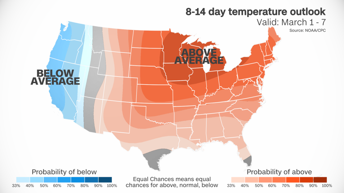
Temperatures across the eastern two-thirds of the US are forecast to remain above average through at least early March. The northern tier of the US will also likely remain unseasonably warm beyond then, through much of March, according to the Climate Prediction Center.

