


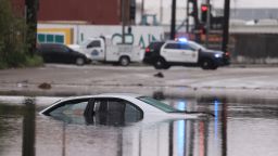
California is bracing for a stronger and longer-lasting atmospheric river event this weekend, which is expected to bring mudslides, damaging winds, and heavy mountain snow and has already triggered flood watches for nearly 40 million people.
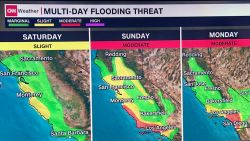
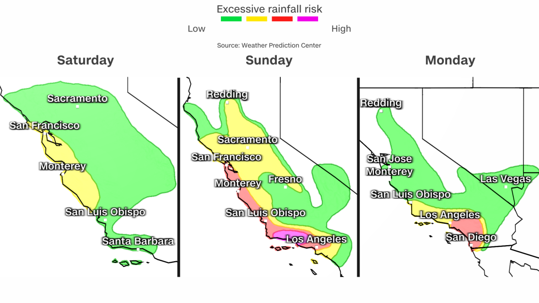
The Weather Prediction Center has issued a rare Level 4 of 4 risk of excessive rainfall for Santa Barbara and Oxnard on Sunday. A more widespread Level 3 risk exists for much of coastal California, including San Francisco down through Los Angeles.
It’s hard to emphasize how big of a deal and how rare a Level 4 “high risk” area is. They are issued on fewer than 4% of days per year on average, but are responsible for more than 80% of all flood-related damage and 39% of all flood-related deaths.
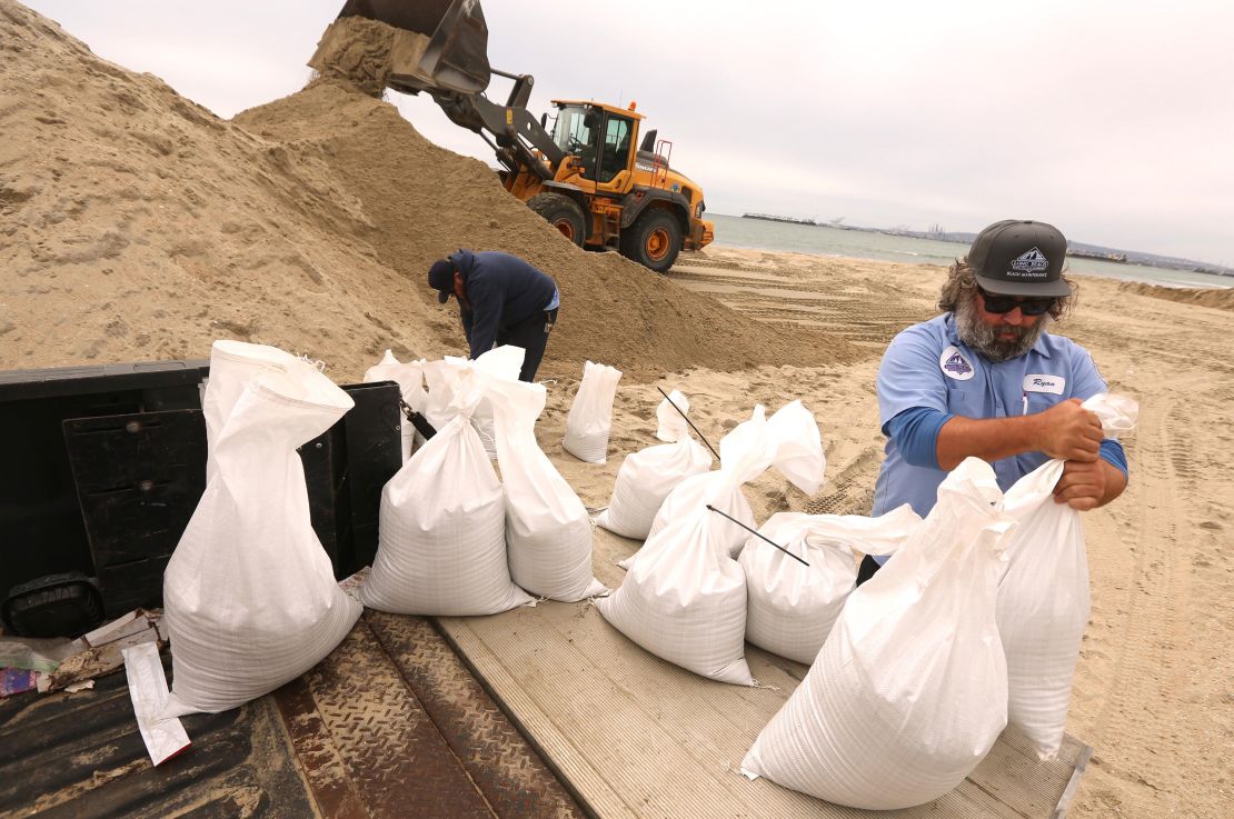
As of Saturday afternoon, more than 8,500 members of multiple public safety organizations have been mobilized in preparation for the extreme weather, Nancy Ward, director of the Governor’s Office of Emergency Services, said in a news conference on Saturday.
More than 7 million sandbags have been prepared and plenty of rescue equipment is on standby, Ward added.
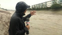
Parts of the central and southern coastline of the state are expected to see the most significant amounts of rain and flooding, according to Eric Schoening with the National Weather Service. This includes the Los Angeles and San Diego metro areas.
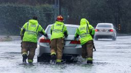
“This damaging flooding will be a threat to lives and property,” Schoening said.
The worst of the storm will fall between Sunday and Tuesday, according to the service.
Governor Gavin Newsom activated the state’s emergency operation center, which will be running 24 hours a day, according to Ward.
Rainfall is expected to begin as early as late Saturday night for central portions of coastal California where a few inches of rain by early Sunday morning may lead to flooding.
The prediction center cautioned at least 8 inches of rain is possible in less than 24 hours for portions of the Transverse Ranges in Southern California, with maximum totals just over 10 inches possible in locations where storms repeatedly occur in a short period of time.
In central and southern California, widespread rainfall totals of 3 to 6 inches are expected – more than a month’s worth of rain for most. Los Angeles averages 2.99 inches of rain in February – their wettest month of the year on average. In the mountains and foothills of Southern California the weather service is forecasting up to a foot of rain. And some parts of Long Beach, California could potentially see more rain this weekend than they typically see in a year, according to Mayor Rex Richardson. The city is anticipating anywhere from 5 to 7 inches, causing flooding and power outages.
On Saturday morning, the Ventura County Sheriff’s Office issued evacuation orders for some communities, along with warnings and advisories about the incoming weather.
The orders, which are in place in anticipation of impacts related to the rain forecast for the weekend, will be in place from 5 p.m. local time Saturday until 5 p.m. Sunday, according to a release from the sheriff’s office.
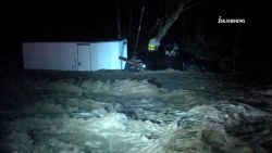
The sheriff’s office also warned residents of the potential for landslides or debris flows, which may be caused by the amount of anticipated rain.
Later in the day, the Santa Barbara Office of Emergency Management also issued mandatory evacuation orders for parts of the city, citing “life-threatening” floods. The orders will be in place until further notice.
There are indications the storm may be as strong as Tropical Storm Hilary from last August, Los Angeles Mayor Karen Bass said during a news conference Friday, and encouraged residents to take “common sense precautions.” She urged people to stay at home and off the roads, keep up to date with the latest information, and make sure they are prepared with emergency supplies.
And the severe weather prompted NASCAR to reschedule its Busch Light Clash Los Angeles from Sunday to Saturday night. The organization urged fans “to make decisions in the best interest of safety.”
Coming storm could stall onshore
This new atmospheric river comes right on the heels of a storm that brought record rainfall to most of California including Sacramento, Eureka, and Los Angeles. But the upcoming storm is much slower and is expected to stall as it moves onshore, bringing a much longer duration of rain compared to the first.
The weather service is concerned about the possibility of nearly continuous moderate to heavy rainfall lasting up to 48 hours, Sunday and Monday.
Flooding and mudslide concerns are high because the ground is already wet from the first storm.
Los Angeles International Airport picked up nearly a month’s worth of rain – 2.49 inches – Thursday.
The ground is also saturated farther north from an abundance of rain at the start of the year. Crescent City and Eureka both had their wettest January on record and are now expecting 1 to 3 inches through Tuesday.
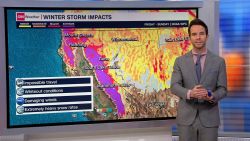
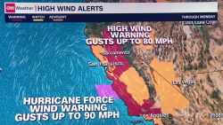
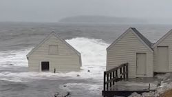
High winds will also be a concern across much of California with widespread winds of 40 to 60 mph and some gusts as high as 75 to 80 mph. This is likely to lead to downed trees and power outages.
“Confidence is strong that this will be as much of a wind event as it is a rain event,” the National Weather Service office in San Francisco said. “If anything recent model guidance has doubled down of wind potential.”
Wind advisories and high wind warnings stretch across pretty much the entire state of California from Redding down through San Diego affecting nearly 30 million people.
For coastal central California, there is also potential for severe storms on Sunday, including in San Jose and Salinas. The main threats are isolated tornadoes and damaging winds.
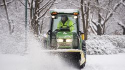
This storm is not just a rain and windmaker – it will also bring significant snowfall.
“What looks like the most significant and impactful storm of the winter season so far is knocking on our door,” the weather service office in Reno, Nevada, which also forecasts for parts of California, said. “Plan on major travel impacts in the Sierra from Sunday through Tuesday due to heavy snowfall. Best to get where you need to be on Saturday and hunker down until this storm wraps up.”
In eastern California, along the Nevada border, Mono County, which includes famous tourist destinations such as Mammoth Lakes and Yosemite National Park, is the target for what could be significant snow totals.
“Mono County will receive a double whammy from this storm, with notably higher snowfall totals as a result,” the NWS office in Reno said. “Through Monday night, there is an 80-90% chance for 4+ feet of snowfall above 8,000 feet (yes, that includes Mammoth Lakes).”
CNN Meteorologist Taylor Ward and CNN’s Sara Smart contributed to this story.

