Story highlights
Soaking storms will raise the flood threat as wet weather arrives
Roads and low-lying areas are at the greatest risk for flooding
Storms are ahead for Northern and Southern California
The second round may be worse than the first
The first in a potent pair of atmospheric river-fueled storms is lashing Northern California with heavy rain and wind Wednesday.
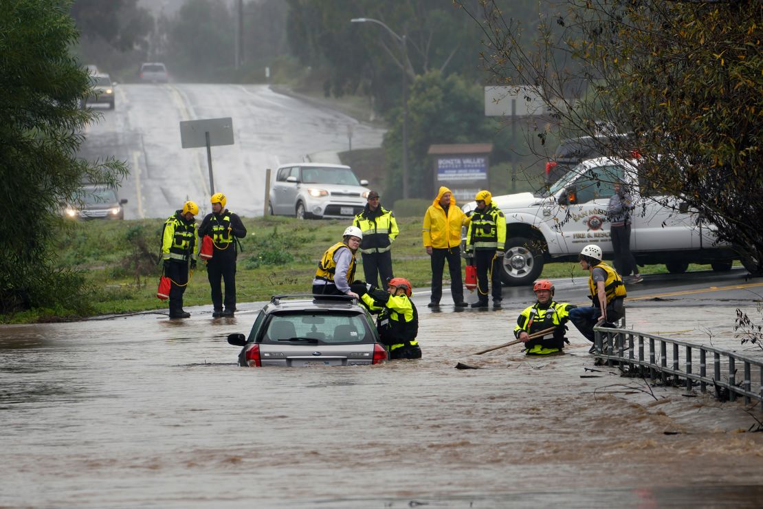
More than 20 million people across California were under flood alerts Wednesday as the soaking storms raise the flood threat across much of the state into next week.
The wet pattern will likely continue well into February as a more typical El Niño pattern kicks into gear after going missing to start winter.
El Niño – a natural phenomenon in the tropical Pacific that influences weather around the globe – causes changes in the jet stream that can point storms directly at California. Storms can also tap into an extra-potent supply of moisture from the tropics called an atmospheric river.
El Niño hasn’t materialized many atmospheric rivers for California so far this winter, with most hitting the Pacific Northwest.
But all of that is changing this week.
The first of the two potent atmospheric river storms started slamming Northern California Wednesday morning and will sweep down the state through Wednesday night and target Southern California Thursday.
Over an inch of rain soaked elevated areas near the coast in Northern California by Wednesday morning. Strong winds roared in the same areas in the meantime, producing gusts of 50 to 70 mph that knocked out power for some.
Rain and breezy conditions began in the Bay Area late Wednesday morning but the storm’s worst will soak and buffet the area through Wednesday evening.
The storm is starting out very warm – fueled by moisture from near Hawaii that earns it the moniker of a pineapple express – and will unload mainly rain in all but the absolute highest elevations in Northern California Wednesday. Central California should expect steady rain and gusty winds to begin late Wednesday and continue into Thursday.
Steady rainfall and periods of stronger winds will arrive in Southern California by Thursday morning. At the same time, much cooler air will begin to overspread the state.
More snow will accumulate and at lower elevations across parts of Northern California and the Sierra Nevada Thursday as cooler temperatures take over. Feet of snow could bury the highest peaks of the Sierras, with at least 6 inches of snow possible for some lower-elevation mountain roadways.
The snow is welcomed for California’s snowpack, which has been beleaguered by warmth and storms that have brought more rain than snow. This winter’s snowpack is just 52% of average for this time of year, according to the latest survey conducted by the state’s Department of Water Resources Tuesday. Snowpack is a vital water source, and the survey helps California to forecast how much water will be available for the rest of the year.
A few thunderstorms could rumble to life in the western half of California on Thursday and may produce bursts of heavier rain. A series of torrential thunderstorms fueled a prolific rainfall event that plunged San Diego underwater last week.

Flooding is possible across a significant portion of California Wednesday and Thursday. A Level 2 out of 4 risk of excessive rainfall is in place Wednesday for portions of Northern and Central California, according to the Weather Prediction Center. The same risk level exits Thursday for Southern California as the rain shifts south.
Roadways and low-lying areas are at the most risk for flooding, but rises on some waterways are possible.
Showery weather will linger across much of California Friday as moisture slowly pushes out and across the Southwest.
More potent atmospheric river event arrives Sunday
Respite from soaking weather in California will be brief: a second, more potent atmospheric river-fueled storm is expected to arrive Sunday.
The National Weather Service in Los Angeles warned Sunday could kick off the “largest storm of the season.” “It is very likely that this will be a serious 2 to 3 day storm system,” meteorologists there said.
Full details on this storm are still coming into focus, but forecast models are pointing to a more widespread and prolonged flood threat, especially for Southern California. At the very least, another few days of rain and snow are likely across the rest of the state.
The second storm looks to tap into even more robust moisture from an atmospheric river than the first, with the potential to stall over the region and unload several inches of rain from Sunday to around midweek.
Temperatures are also likely to start out much cooler with this storm than with the first storm, with more snow possible down to mountain pass levels or potentially even lower elevations.
A wet, cooler pattern is likely to extend well after the second atmospheric river wraps up.
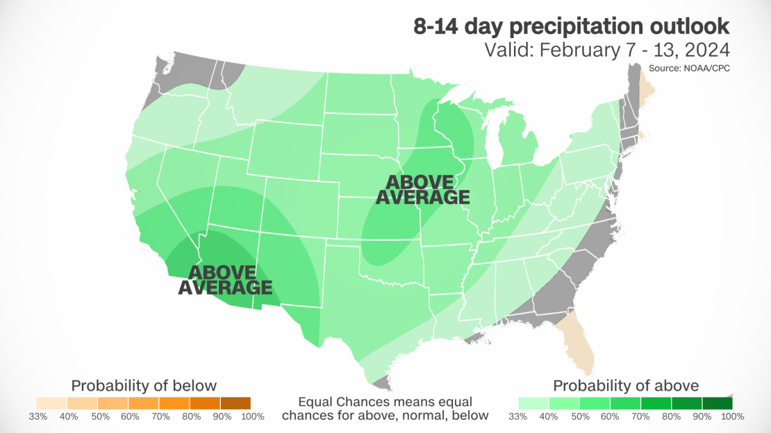
Below average temperatures and above average precipitation amounts are likely to persist into mid-February, according to outlooks produced by the Climate Prediction Center.
CNN’s Stephanie Elam contributed to this report

