


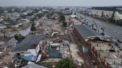
A massive winter storm system has unleashed dangerous blizzard conditions in parts of the central United States, shutting down highways and stranding drivers in frigid temperatures Monday, and it’s pummeling parts of the South with hail storms, heavy flooding and tornado threats.
The fast-moving storm is making its way east and will cover over 1,800 miles in 72 hours, producing notable snowfall across more than half a dozen states.
The system strengthened as it tracked out of the Four Corners region – where it dumped snow that brought some travel to a halt Sunday – and into the southern Plains Monday afternoon.
By Monday evening, heavy snow and powerful winds stretched from the Texas Panhandle to Nebraska, where authorities had already responded to dozens of weather related-incidents on the road and urged residents not to travel because of the dangerous whiteout conditions.
In Kansas, one highway patrol trooper warned the blizzard conditions and blowing snow were making it so difficult to see that authorities were having difficulty with rescues.
“Please stay home,” the trooper said on social media. “We will not be able to rescue you if you get stuck because we are having trouble getting around.”
Further south, heavy showers and hailstorms were moving through Mississippi and parts of Louisiana, while millions of people were also at risk of tornadoes.
The first tornado watch of 2024 was issued Monday for parts of Texas and southwest Louisiana. A second tornado watch was issued through Monday night for southeast Louisiana and coastal Mississippi and covers cities including Baton Rouge and New Orleans.
All that comes as more states prepare for severe weather Tuesday, including parts of the Northeast, where leaders have warned of potentially dangerous rain and coastal flooding.
Here’s what more to expect as this powerful January storm keeps moving.
Tornado risk will increase Monday night
The threat of flooding, damaging winds and tornadoes is at a risk level more typical of spring than the second week of January.
More than 9 million people were under a Level 3 out of 5 severe storm threat Monday from Texas to Florida. More than 11 million people face the same threat level Tuesday from the Panhandle of Florida to the Outer Banks of North Carolina.
The tornado risk will increase Monday night – an incredibly dangerous situation for parts of the Gulf Coast. Tornadoes at night are twice as deadly as those that occur during the day, mainly because a large portion of the population is asleep and miss warnings.
Meteorologists at the National Weather Service office in Mobile, Alabama, warned of “an extremely high impact event for our area” that “could be one of the more impactful non-tropical systems” to hit their forecast area.
The same system is forecast to move across the Southeast throughout Tuesday. There is a Level 3 out of 5 risk of severe storms for Tallahassee, Florida, Savannah, Georgia, Charleston, South Carolina, and Jacksonville, Florida. Tornadoes and damaging winds are also threats with the strongest storms.
Significant inland and coastal flooding likely
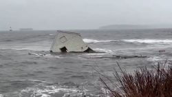
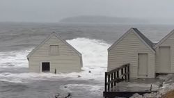
An equally serious concern is the potential for significant flooding from the storm’s strong winds blowing water onshore and its potent rainmaking storms. Flood watches are in place across the Southeast on Monday and in the Northeast on Tuesday.
“Widespread and potentially significant river and flash flooding are likely from the central Gulf Coast through much of the Eastern U.S. early this week,” the Weather Prediction Center said. “Powerful onshore winds will lead to widespread coastal flooding along the eastern Gulf Coast and much of the East Coast.”
Widespread rainfall totals of 1 to 3 inches are expected from the Gulf Coast to New England with isolated locations exceeding 4 inches.
A Level 3 of 4 risk for excessive rainfall and flooding is in place from eastern Louisiana to the Florida Panhandle on Monday.
There’s serious concern for flooding in the Northeast with this next wave of rain coming right after the first snowstorm dropped more than half a foot of snow in multiple Northeast states.
New York City issued a travel advisory and flood watch that’s set to start Tuesday evening, warning of heavy rain, strong wind and the potential of coastal flooding.
“Let me be clear,” New York Gov. Kathy Hochul said in a Monday news briefing. “This will be an emergency, it will be serious and we’re urging all New Yorkers to exercise extreme caution at this time.”
Heavy rain will accelerate snowmelt and increase the amount of water running off into waterways, raising the ceiling on the flood potential in these areas. As a result, there is a Level 3 out of 4 risk for excessive rainfall in portions of the Northeast and the Carolinas on Tuesday. A Level 2 of 4 threat stretches from Georgia through Massachusetts. In North Carolina, Gov. Roy Cooper declared a state of emergency ahead of the expected rain, warning the strong winds may also mean widespread power outages.
The rainfall is both a gift and a concern for Louisiana and Mississippi – both still grappling with serious droughts, though drought has already improved substantially since November from a recent overabundance of rain.
Locations along the Gulf Coast from New Orleans to Tallahassee, Florida, are more than 5 inches above normal for rainfall since December 1, so it won’t take much for the saturated ground to flood.
Strong winds to buffet a large portion of the US
Wind is another concern with saturated ground. It makes trees more vulnerable to toppling over onto power lines or homes. And the winds Tuesday will be strong enough to cause such damage.
Widespread wind gusts of 40 to 60 mph are likely across a wide swath of the central and eastern US as the storm reaches its full strength Tuesday.

The Weather Prediction Center warned people to “prepare for power outages” from the potentially damaging winds.
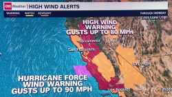
More than 100 million people across the US are under wind alerts that span Monday, Tuesday or both days.
Coastal areas are likely to endure some of the strongest winds from the storm.
The National Weather Service office in Boston noted they might need to issue hurricane-force wind watches – warning of winds akin to a Category 1 hurricane – for coastal areas if the storm’s worst forecast fears came to pass.
Winds will also trigger high surf from 8 to 11 feet and significant beach erosion is possible. Dangerous rip currents are also likely and will continue through at least the middle of the week.
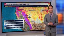
Blizzard conditions to create treacherous travel
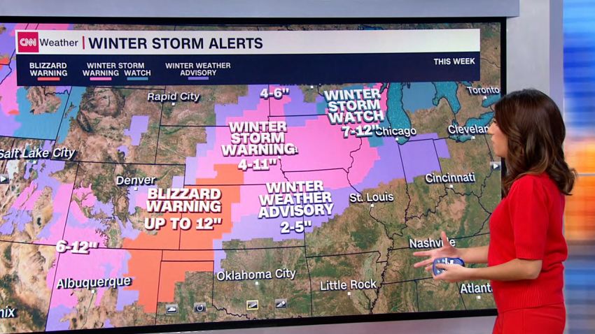
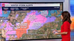
Winter storm alerts stretch over 1,000 miles from Arizona to Michigan as the storm carves its path.
Blizzard warnings are in effect Monday in parts of New Mexico, eastern Colorado, the Oklahoma and Texas Panhandles, western Kansas and southwest Nebraska. Up to a foot of snow could bury parts of the area Monday.
Poor visibility and difficult-to-near-impossible driving conditions have already begun for the central and southern Plains on Monday and shift to the Midwest on Tuesday. Heavy snow is likely to target areas from eastern Nebraska and northern Missouri into Michigan Tuesday.
Strong winds will also push wind chill values below zero for some locations in the Plains, especially Monday night and Tuesday night.
Snowfall will then spread into the interior Northeast Tuesday afternoon and evening. Snow will linger, mainly in elevated areas of New York and New England through Wednesday.
The storm looks to wrap up by the end of the week, but another storm could follow a similar path and affect some of the same areas from Friday into the weekend.
CNN’s Robert Shackelford, Taylor Ward, Joe Sutton, Rob Frehse and Christina Maxouris contributed to this report.

