
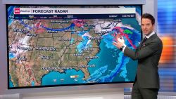


A substantial storm is poised to smack the Northeast and parts of the mid-Atlantic with winter’s first dose of big snow and dangerous ice.
Winter storm watches, warning the millions in the storm’s path of its weekend arrival, were hoisted Thursday from southern North Carolina to southern Maine.
As of Thursday, the highest confidence for significant snow was in portions of the interior Northeast, including central Pennsylvania and southeastern New York state, and southern and central New England, including areas just west of Boston.
That means cities like DC, Baltimore and New York – all waiting nearly two years for an inch of snow in a calendar day – could miss out on snow and instead experience rain or wintry mix.
But just 50 miles could separate areas that experience heavy snow from those that experience mixed precipitation or only rain, meaning small shifts in the storm’s final track and timing will make a massive difference.
Regardless of the storm’s final snow totals, an impactful winter storm capable of disrupting travel is coming.
What to expect in major cities
Forecast model trends have not been kind to snow lovers in the major cities along the Northeast’s I-95 corridor, where it appears there won’t be sufficient cold air to churn out much snow there. Instead, rain and wintry mix is more likely.
But farther inland, this storm could produce 6 to 12 inches of snow in parts of the interior Northeast and New England, where the heaviest snow is expected. The main event for snow in the Northeast will be Saturday night and Sunday as the storm tracks through the area and then off the coast.
Here’s a breakdown of what is expected in major metro areas as of Thursday morning, according to the National Weather Service.
- DC and Baltimore areas: Downtowns look set to miss out on an inch of snow. The greatest chance for snow is north and west of I-95, where 1-3 inches are possible – and even bigger totals are possible west of I-81.
- Philadelphia area: Downtown will be wet, not white. The greatest chance for snow is north and west of the city, where the Lehigh Valley could see 3-4 inches of snow, with heavier amounts in the Poconos.
- New York City area: Less than an inch of snow is expected in the five boroughs and Long Island. Snow chances rise north and east of the city into the Hudson Valley with 2-4 inches possible and similar totals expected in coastal areas of Connecticut.
- Boston area: The downtown forecast could change with higher uncertainty there, but 4-6 inches is currently expected. Higher totals of 8-12 inches are possible west of I-95 in places like Worcester, Massachusetts.
Heavy rain and ice potential
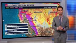
The system responsible for the potential winter weather will first cross the southern half of the US through Friday, before swooping up the East through the weekend.
In much of the South and Southeast this will mean a cool rain as the storm taps into ample moisture from the Gulf of Mexico.
Some storms could turn severe on Friday closer to the Gulf Coast where there’s more potential for heavy rain and flooding.
For Louisiana and Mississippi, still suffering from drought after a summer of extreme heat and a lack of rain, the rain will be largely beneficial.
Rain will begin Thursday evening in central Texas and progress with the storm’s track to the east, overrunning the Southeast through Friday.
The storm will then drive north into the mid-Atlantic Saturday dumping heavy rain and freezing rain on parts of the southern Appalachians and Piedmont. The chance for 0.1 inches of ice or greater there will make travel treacherous, especially given the elevation.
Historic snow droughts could continue
Despite lower snow chances, if even an inch were to fall in major cities along the I-95 corridor, it would end significant snowless streaks for some that have dragged on for nearing two years.

New York City has waited nearly 700 days for an inch of snow in a single calendar day. Only 2.3 inches fell in Central Park during the entirety of 2023, making it the city’s least snowy calendar year on record, according to the National Weather Service. The same was true for Philadelphia and the DC area’s Dulles International Airport.
It’s not as if the Northeast has gone without precipitation. In mid-December, a powerful and deadly coastal storm knocked out power to hundreds of thousands and triggered severe flooding across the region.
But it’s just been too warm for precipitation to fall as snow, something that’s becoming more common as global temperatures rise because of planet-warming fossil fuel pollution.
Much of the US endured a warmer-than-average December. The warmer temperatures meant snow was harder to come by. As a result, snow cover, or how much land is covered by snow, is at its lowest extent in North America since 2005, NOAA data shows.

