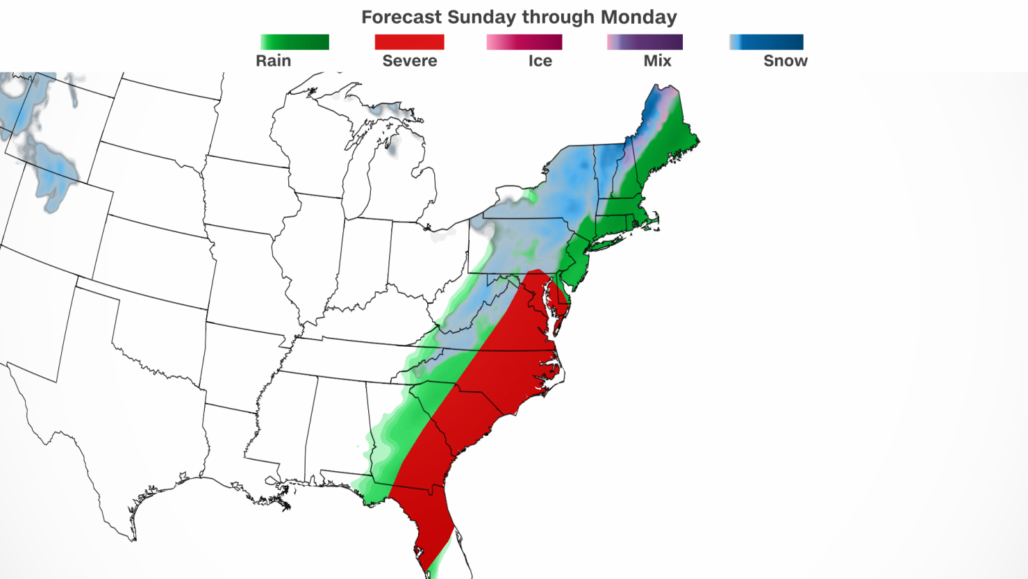
A massive storm is delivering more severe thunderstorms, heavy rainfall and strong winds to portions of at least a dozen eastern US states Sunday – with snow still to come.
The robust storm threatens to upend travel and knock out power through the start of the work week after spawning deadly tornadoes in Tennessee on Saturday.
Rain and embedded thunderstorms stretched from the Southeast to the Northeast on Sunday afternoon as the sprawling storm reached peak strength.
The flood risk from the storm is especially concerning, particularly in New England, but the threat for more tornadoes and damaging storms in parts of the Southeast will also be worth watching Sunday.
A slight risk, or Level 2 of 5, for severe thunderstorms is in place Sunday for portions of the eastern Carolinas and southeast Virginia, according to the Storm Prediction Center. The atmosphere there is primed for thunderstorms that could unleash damaging wind gusts and even a few tornadoes during the afternoon and evening.
Portions of Florida are also under a Level 2 risk of severe thunderstorms into Sunday evening.
Places that manage to dodge severe thunderstorms will not avoid adverse weather entirely as a heavy rain threat and flooding chances increase.
Widespread rain totals of 1 to 2 inches are likely from Florida to New England on Sunday. Higher amounts of 3 to 4 inches are possible for areas in the Northeast caught under repeated downpours, especially closer to the coast.
More drenching rain will target New England on Monday and two-day rainfall totals in the region could eclipse 4 inches. Isolated locations may pick up close to half a foot of rain by storm’s end.
The concern for flash flooding rose on Sunday afternoon in Connecticut, Rhode Island and Massachusetts and prompted the Weather Prediction Center to upgrade the risk of excessive rainfall in these areas to a Level 3 out of 4.
A slight risk, or Level 2 of 4, of excessive rainfall is in place across a broader area of New England both Sunday and Monday, according to the Weather Prediction Center.
Flash flooding is also possible in other parts of the Northeast, especially in poor drainage areas or where rainfall totals climb very quickly. Heavy rainfall could also cause waterways to rise, ponding on roadways and urban flooding.
Gusty winds will accompany heavy rainfall, increasing the danger. Widespread gusts of 40 to 50 mph will slam portions of the mid-Atlantic and Northeast within about 150 miles of the coast.
Gusts could strengthen and reach up to 60 mph at times Sunday night in New England and along the New York and New Jersey coastlines.
Winds this strong, especially when coupled with drenching rain, could bring down a few trees and cause power outages. Strong winds and rain may also disrupt air travel across the busy corridor and lead to slowdowns for drivers.
Areas farther inland across the mid-Atlantic and Northeast will still get quite breezy on Sunday, but damaging winds are less likely.
And if that wasn’t enough, snow will also fall on Sunday night. Rain will change over to wet snow across portions of the interior Northeast and continue through Monday.
Winter storm warnings were issued for parts of the interior Northeast for Sunday night through Monday evening and include parts of New York, Vermont, Pennsylvania and New Hampshire.
Snow will reach Maine on Monday and continue to fall across Vermont and New Hampshire. A mix of rain and snow will taper off across upstate New York through Monday afternoon. This same mix will persist into Monday evening in parts of southern New England before the center of the formidable storm tracks out of the US.
Strong wind gusts will continue to impact New England, especially along the coast, into Monday night, and will only cease once the potent storm clears the area.
CNN Meteorologist Sara Tonks contributed to this report.


