Naples, Florida, officials issued an emergency citywide curfew on Wednesday.
City officials asked residents to shelter in place until further notice.
"As Hurricane Ian approaches landfall, extremely hazardous conditions are on our roadways. The City of Naples has issued an emergency citywide curfew to protect and safeguard the health, safety, and welfare of City of Naples residents, visitors, and first responders," said the city notice.
The curfew does not apply to first responders and emergency workers, said the notice.
1:24 p.m. ET, September 28, 2022
Videos show formidable storm surge at Hurricane Ian's eye wall
Storm chaser Reed Timmer documented on Twitter the storm surge at Pine Island, Florida, as Hurricane Ian's eye wall hammered the area.
His videos show crashing waves, heavy rain, gusty winds and limited visibility.
Most of Florida’s citrus belt is threatened by Hurricane Ian, satellite images show
From CNN’s Matt Egan
Hurricane Ian's expected damaging wind and flooding is threatening most of Florida’s massive citrus industry.
At least 75% of the Florida citrus belt is under threat of heavy flooding rains over the next 36 hours, according to satellite imagery provider Maxar Technologies.
Maxar’s WeatherDesk finds that at least a third of the groves are likely to see some wind damage, mostly in the northwestern portion of the citrus belt.
How the market is reacting: Florida is a leading citrus producer, including oranges and grapefruit. Orange juice futures jumped 4% on Wednesday afternoon as investors bet supply will be hurt by Hurricane Ian. The price is up by almost 30% so far this year.
The timing of the storm is difficult for farmers in Florida as citrus crops are nearing harvest season.
“There will be quite a bit of fruit drop and losses of fruit from the trees,” Maxar said.
Citrus production was already under significant pressure even before Hurricane Ian.
In July, the US Department of Agriculture estimated US production of oranges would drop by 13% in 2021 AND 2022 to the lowest level in 55 years because of the drought in California and citrus greening in Florida.
1:28 p.m. ET, September 28, 2022
Storm surge could be "life changing," Florida's Lee County sheriff says
From CNN’s Naomi Thomas
A potentially 18-foot storm surge could be life changing, Lee County Sheriff Carmine Marceno, said on CNN’s "Inside Politics" Wednesday.
“I’ll tell you, you talk about an 18-foot storm surge, I mean that’s life changing,” Marceno said. “I’m worried about everybody in my county, those coastlines, those lowland coastlines, Cape Coral is a huge city, over 200,000 residents, all the barrier islands, you worry about everything as sheriff.”
Lee County is in Southwest Florida and includes cities such as Fort Myers, Cape Coral and Sanibel.
1:22 p.m. ET, September 28, 2022
Florida is experiencing wind gusts over 100 miles per hour
From CNN meteorologist Allison Chinchar
Category 1 hurricane-force winds and higher gusts are spreading inland across central Florida as of 1 p.m. ET.
The center of Hurricane Ian is only 35 miles west of Fort Myers and 45 miles southwest of Punta Gorda as of the 1 p.m. ET update from the National Hurricane Center.
Here's a sample of observations from the past hour:
Naples Grand Beach: 112 mph
Punta Rassa: 107 mph
Sanibel Island: 107 mph
Captiva: 100 mph
St. James City: 97 mph
1:22 p.m. ET, September 28, 2022
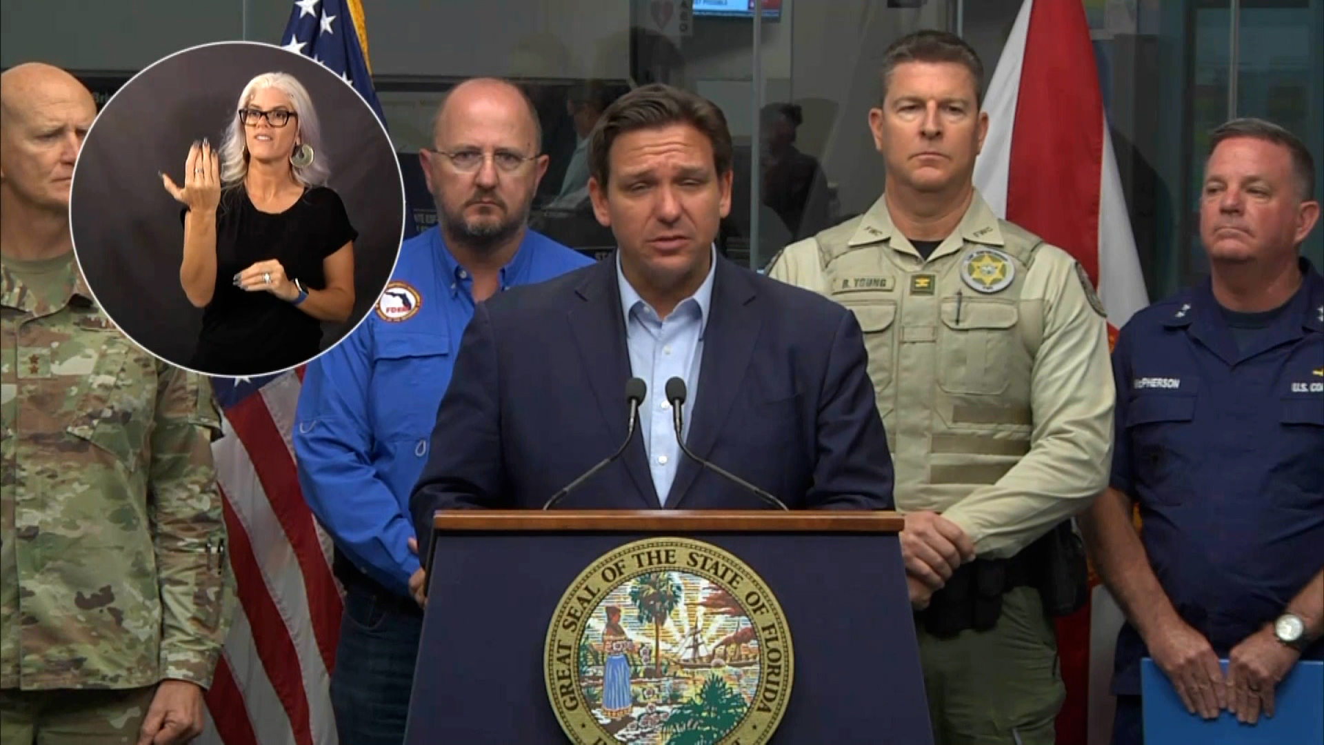
"It may appear to be calm at some point — you may just be in the eye of the storm," Florida governor warns
(Governor DeSantis' Office)
Florida Gov. Ron DeSantis urged residents to be cautious and stay inside as Hurricane Ian is set to make landfall soon.
"It may appear to be calm at some point — you may just be in the eye of the storm, and the back side of that will get very, very nasty," he said.
He urged residents to stay inside until the storm passes, adding other warnings for residents to heed when navigating the situation.
"Once the storm has passed and it is safe to go outside, you still need to be cautious. Avoid downed power lines, standing water. Stay clear of downed trees and don't drive in standing water. And please, if you are going to use a generator for your home, do not allow that to be inside — the exhaust needs to be outdoors. Stay out of the way of emergency crews out of Florida waters and away from all downed power lines. Stay off the roads. There is no need to rush back," he said.
DeSantis warned of massive power outages to come.
"We have 200,000 power outages recorded throughout the state of Florida. But outside of southwest Florida, crews are working to quickly restore power," he said.
"Of course 200,000 is a drop in the bucket for what will happen over the next 24 to 48 hours. There will be widespread power outages particularly in southwest Florida. We have over 100 portable cell towers ready to be deployed into the area once it is safe to enter," he noted.
1:18 p.m. ET, September 28, 2022
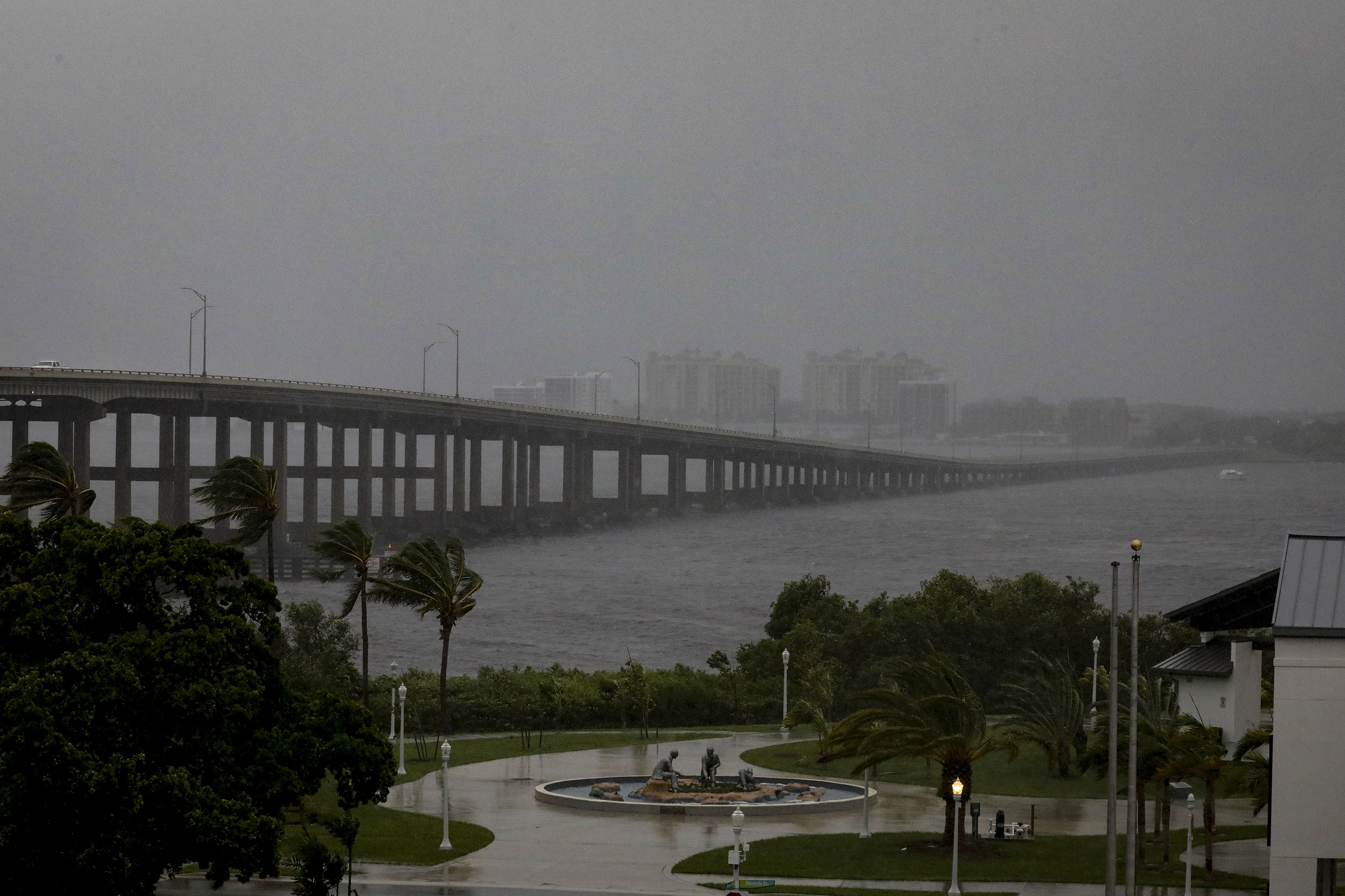
Fort Myers is in "the thick of things" as storm conditions hit city, mayor says
From CNN’s Naomi Thomas
Heavy rain and wind is seen at the Caloosahatchee Bridge in Fort Myers, Florida, on Wednesday. (Eva Marie Uzcategui/Bloomberg via Getty Images)
Fort Myers, Florida, Fire Chief Tracy McMillion told CNN on Wednesday afternoon that the city is currently “in the thick of things,” urging people to stay sheltered in place.
“We are in the thick of things,” McMillon said. “Now is the time to stay inside. One of the messages that we’re putting out there is to stay in and check in, talk to your family, talk to your relatives, let them know where you are."
"In addition to that, we’re asking folks to stay away from windows, stay away from openings and get to a central place in your home that’s built up by walls, fairly narrow. And so, this way you can hunker in and kind of ride this out. We are in the thick of it," the mayor added.
McMillion said that officials don't know exactly how many people are waiting the storm out at home, but county partners have told them that there’s about 4,000 people in the shelters provided in the county and plenty of room left in them. It's unclear how many people left the area completely, he said.
“There’s really no way to really determine how many folks at this point in time are still in their homes, but that’s something that we’re going to be aggressive with when the time and opportunity gets available for us to get back on the roads and start doing emergency response with our first responders,” he said.
After the storm moves through, “we’re not really sure what it’s going to look like, and this is one of the things when it comes to storms, especially big storms like this one,” he said. “We don’t know the cards or the hand that we’re going to be dealt from Ian, but we are ready to actually play the deck and do the best we can to actually make sure our community’s safe as we go out with recovery efforts.”
1:19 p.m. ET, September 28, 2022
Georgia's Chatham County is under hurricane watch as Ian’s path remains uncertain
From CNN’s Rebekah Riess
Georgia's Chatham County, which includes Savannah, has been placed into a hurricane watch, Dennis Jones, the county's emergency management agency director, said.
The National Weather Service in Charleston “wanted to go forward and make sure that they had this watch in place just in case,” according to Jones.
The county is also currently under a storm surge and tropical storm warning. Additionally, the mayor of Savannah on Wednesday morning declared a local state of emergency as the city readies for the impacts from Hurricane Ian.
“The forecast models for this storm are not as tightly converged as we would like for them to be, which is why the uncertainty exists,” Jones said. “Some of these models have it coming back into Georgia, some of them have it going out to the Atlantic, some of them having it accelerating way up into the northwest part of the Atlantic. So we will continue to watch every advisory that comes out and we will take seriously those watches and warnings that are affecting our particular area.”
Jones said conditions should start deteriorating throughout the day Thursday, with it getting worse Thursday night, moving into Friday.
The director said the county has been in touch with all of its law enforcement entities, as well as fire services and EMS providers. “They all assure us that they are ready to go. They don't have any unmet needs at this time and they're ready to respond to the storm,” Jones said.
1:09 p.m. ET, September 28, 2022
United cancels flights from more Florida airports
From CNN's Pete Muntean and Greg Wallace
United Airlines is starting to shutter operations on the Atlantic coast of Florida in anticipation of Hurricane Ian’s path after it makes landfall.
By Wednesday afternoon, United said it will halt departures from West Palm Beach, Miami and Fort Lauderdale airports. United will not operate from Jacksonville starting on Thursday.
United said it has proactively canceled 345 flights since Tuesday, swapping some outbound flights with larger airplanes to help customers who were evacuating from the storm’s path.
The latest data from FlightAware shows nearly 2,100 cancelled flights in the US Wednesday and another almost 1,700 cancelled in the US on Thursday.