Every US state is under a weather alert

Powerful winter storm hits eastern half of the US

By Mary Gilbert, Elizabeth Wolfe, Eric Zerkel, Adrienne Vogt, Zoe Sottile and Tori B. Powell, CNN

Updated 1820 GMT (0220 HKT) January 13, 2024
15 Posts
Sort byDropdown arrow
9:54 a.m. ET, January 12, 2024

Every US state is under a weather alert

From CNN Meteorologist Mary Gilbert

A man clears snow off a sidewalk in Des Moines, Iowa, on Friday, January 12.
A man clears snow off a sidewalk in Des Moines, Iowa, on Friday, January 12. Abbie Parr/AP

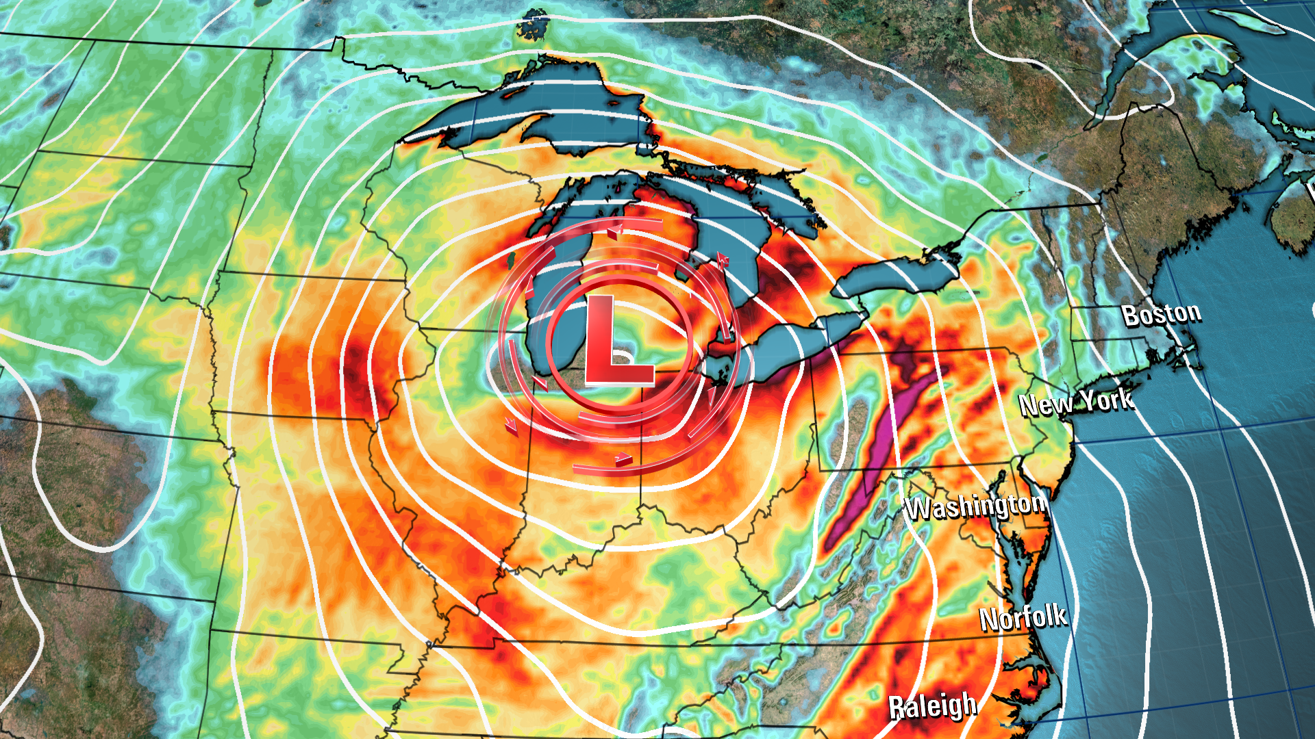
The massive storm slamming the eastern half of the US is only one piece in a very active weather pattern. Multiple weather hazards are impacting the country Friday morning, so the National Weather Service has issued some kind of weather alert for every state.

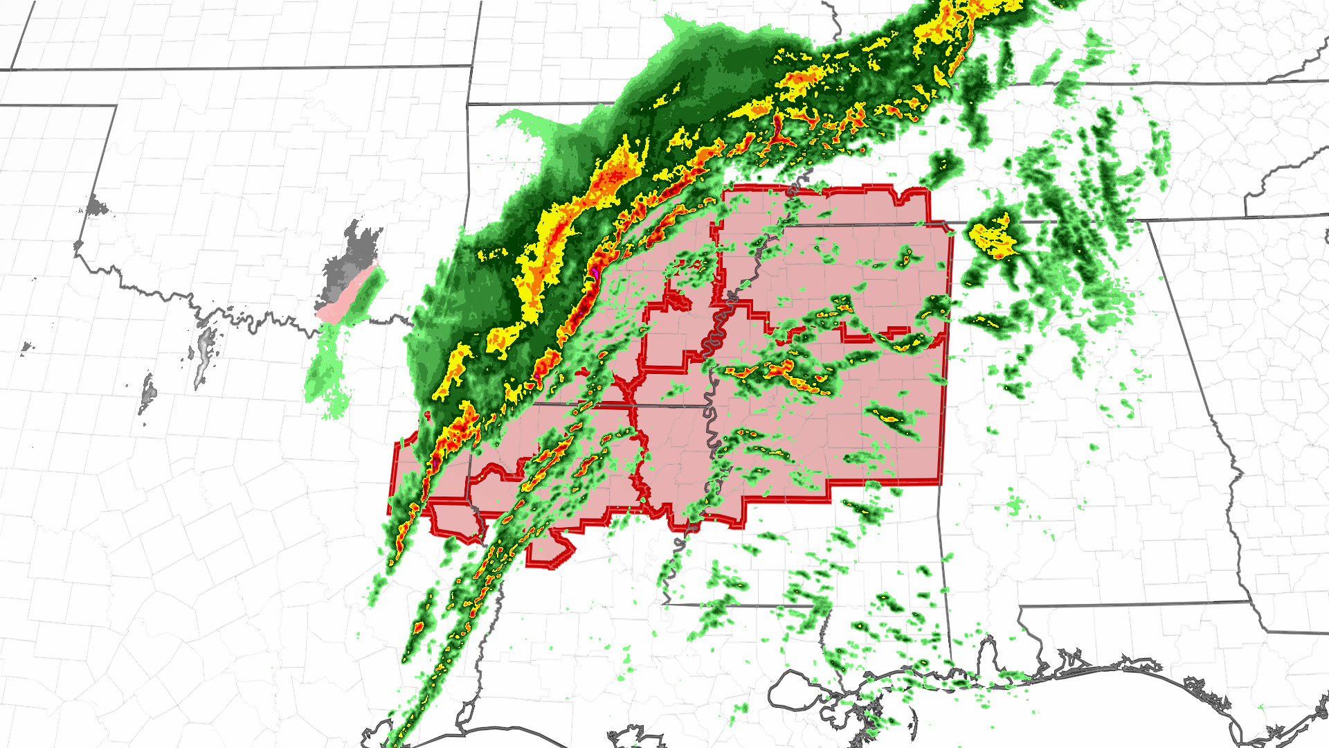
Everything from blizzard warnings to tornado warnings are in effect early Friday as the massive storm works its way across the eastern half of the US. Wind alerts stretch nearly 2,000 miles from Texas to New England, while flood alerts span from the mid-Atlantic to Northeast.  

Another robust storm in the Northwest is bringing snow and wind to the region and temperature alerts dot several states as brutally cold air starts to seep south out of Canada. 

Alerts are in effect in Alaska ahead of a winter storm set to impact the state this weekend. Even Hawaii is dealing with the impacts of stormy weather as a potent cold front slices across the islands.

Track winter weather alerts across the US here.

8:27 a.m. ET, January 12, 2024

This storm could bomb out. Here's what that means

From CNN Meteorologist Mary Gilbert

A forecast model shows a powerful storm at its full strength Friday night, producing robust wind gusts while centered over the Great Lakes.
A forecast model shows a powerful storm at its full strength Friday night, producing robust wind gusts while centered over the Great Lakes. CNN Weather

The potent storm tracking across the central US will continue to strengthen on Friday, bringing all modes of hazardous weather to the eastern half of the country.  

At the storm’s peak intensity Friday night, it may strengthen enough to bomb out, or be considered a bomb cyclone: a rapidly strengthening storm that undergoes a significant drop in pressure — a measure of a storm's strength — in a short time. Bomb cyclones are formidable and unload heavy snow and strong winds during the winter. 

A storm must drop at least 24 millibars (which is a unit of pressure) in 24 hours or less to meet bomb cyclone criteria. But technically, the exact millibar drop needed will vary slightly based on the storm’s exact latitude.  

The Weather Prediction Center doesn't show the storm officially hitting bomb cyclone status, but several forecast models showed the potential exists. Bomb cyclone or not, it could end up stronger than the last powerful storm, which set January records for strength as it passed over Indiana.

7:10 a.m. ET, January 12, 2024

Water levels on Maine's coast could rival destructive, historic highs once again

From CNN's Eric Zerkel

A man wades through a flooded parking lot near Widgery Wharf on January 10, in Portland, Maine.
A man wades through a flooded parking lot near Widgery Wharf on January 10, in Portland, Maine. Robert F. Bukaty/AP

Water levels on Maine's coast are forecast to hit historic highs on Saturday, threatening to inflict more damage on coastal communities still reeling after a storm earlier this week sent water surging onshore.

Water levels at gauges from Portland to Eastport were forecast to top levels from Wednesday during the last storm, according to data from the National Oceanic and Atmospheric Administration. Portland and Bar Harbor both hit new historic high-water marks on Wednesday.

The water level reached 15.49 feet in Bar Harbor Wednesday morning and is forecast to top 17 feet by noon Saturday. The previous record in Bar Harbor was 15.04 feet in 2018.

The water is projected to top 14 feet in Portland Saturday morning, slightly higher than the 13.84 feet hit on Wednesday morning, which broke the previous record set in 1978, NOAA said. 

Maine's governor issued a State of Civil Emergency Thursday for all eight of the state's coastal counties after the storm surge caused destruction there.

“Significant rain, wind, and flooding have once again ravaged our state – this time our small communities up and down the coast,” Gov. Janet Mills announced Thursday. “The damage we are seeing is devastating, from working waterfronts, to small businesses, to public roadways and more.”

The exceptionally high water is being driven by strong winds blowing water from the Atlantic Ocean toward the shore on top of high tide. Heavy rain inland only exacerbates the flooding. 

Climate change is also playing a role. Sea levels are rising as global temperatures climb and melt glaciers and ice sheets. Higher sea levels are making coastal flooding events worse and will continue to do so in the future. 

7:56 a.m. ET, January 12, 2024

A burst of snow is falling in Chicago. There's a lot more to come

From CNN Meteorologist Mary Gilbert

Heavy, wet snow is moving across the Chicago area early Friday morning and could leave some parts of the metropolitan area with close to 6 inches of snow by the afternoon.

The National Weather Service in Chicago urged people across northern Illinois to "strongly consider postponing travel" Friday morning, warning of snowfall rates of 1 to 2 inches per hour.

The most snow will be largely in the western and northern Chicago suburbs Friday morning, away from the influence of Lake Michigan's abnormal warmth.

Snow will mix with rain across southern portions of the metro and areas along the lakeshore Friday afternoon, before changing back over fully to snow Friday evening once colder air arrives. Steady snowfall throughout the day will send totals skyrocketing for areas away from the lakeshore.

Very strong winds will arrive Friday evening across northern Illinois and combine with falling snow for another period of treacherous travel across the region, Chicago included.

5:43 a.m. ET, January 12, 2024

Tornado watch issued for more than 5 million people in the South

From CNN Meteorologist Mary Gilbert

Tornado watch and current radar.
Tornado watch and current radar. CNN Weather

More than 5 million people across portions of Texas, Arkansas, Louisiana, Tennessee and Mississippi are under a tornado watch as intense thunderstorms rumble across the South Friday morning.

The tornado watch is in effect until 11 a.m. CT and includes Little Rock, Arkansas, Shreveport, Louisiana, and Jackson, Mississippi.

Thunderstorms stretch from the Texas Gulf Coast as far north as Illinois and Indiana early Friday morning.

But the greatest risk for these storms to turn severe and unload damaging winds, hail and tornadoes is over the Lower Mississippi Valley, where a Level 3 out of 5 risk for severe thunderstorms is in place.

5:42 a.m. ET, January 12, 2024

Coastal flooding is a significant concern for the Northeast this weekend

From CNN Meteorologist Robert Shackelford

Water rises at a residential area in an aftermath of a storm in Piermont, New York, on January 10.
Water rises at a residential area in an aftermath of a storm in Piermont, New York, on January 10. Eduardo Munoz/Reuters

Another bout of rain will fall on the already-soaked Northeast on Friday, threatening to trigger disruptive and damaging coastal flooding in several of the region's major cities through Saturday.

More than 7 million people are under coastal flood warnings along swaths of the Northeast, including residents of Philadelphia and parts of New York, where Nassau and Suffolk Counties could be overwhelmed with up to 3 feet of coastline flooding.

"This will result in extensive road closures and flooding of low-lying property including parking lots, parks, lawns and first floors and basements of homes/businesses near the waterfront," the National Weather Service in New York warned. "Vehicles parked in vulnerable areas near the waterfront will likely become flooded and/or submerged."

In New York City, where a coastal advisory is in place, 1 to 2 feet of water could inundate ground-level areas. 

About 35 million people -- stretching from North Carolina to eastern Massachusetts -- are under flood watches Friday as the storm pushes through the eastern US.

3:57 a.m. ET, January 12, 2024

More than 50 million in the Southeast are under a severe storm threat

From CNN Meteorologist Robert Shackelford

More than 50 million people are under a severe storm threat across the Southeast on Friday after overnight storms brought high winds and almost a dozen reports of large hail in the South.

Parts of northern Alabama and Mississippi are the most at-risk for severe weather, with the main threats being powerful winds, large hail and a chance of tornadoes.

A tornado watch is in effect until 5 a.m. ET for parts of western and central Arkansas, northwestern Louisiana, southeastern Oklahoma and northeast Texas.

Other major cities in the storm's path include New Orleans, Atlanta, Nashville, Tennessee, and Tampa, Florida. 

3:49 a.m. ET, January 12, 2024

More than 1,000 flights have been canceled across the US so far today

From CNN's Joe Sutton

As winter weather sweeps the country, more than 1,170 flights have been canceled within, into or out of the United States so far today, according to tracker Flight Aware.

In Chicago, which is set to receive more than 8 inches of snow, O'Hare International Airport tops the charts with more than 400 flights canceled in and out of the travel hub. The city's other airport, Midway International, is also among the hardest-hit with more than 100 cancelations.

Other airports with a high number of cancelations include Denver International Airport in Colorado, Milwaukee Mitchell International Airport in Wisconsin and Newark Liberty International in New Jersey.

Here's what to do if your flight is canceled or delayed.

4:03 a.m. ET, January 12, 2024

A forecast for some cities in the Midwest

From CNN Meteorologist Robert Shackelford

A member of the media walks from the debate hall during the Republican primary presidential debate hosted by CNN in Des Moines, Iowa, US, on January 10.
A member of the media walks from the debate hall during the Republican primary presidential debate hosted by CNN in Des Moines, Iowa, US, on January 10. Al Drago/Bloomberg/Getty Images

Here's a look at the snowfall and other conditions expected in some of the Midwestern cities in the storm's path. All times are local to the cities indicated.

Chicago

  • Alert: Winter storm warning from early Friday to noon Saturday
  • Snowfall: More than 8 inches; rates could exceed an inch per hour
  • Peak snowfall: Friday morning and Saturday morning (commutes could be impacted)
  • Winds: Gusts up to 45 mph, peaking Friday morning through Saturday
  • Wintry mix: Snow will mix with rain near Lake Michigan, limiting snow accumulations after mid-morning Friday

Des Moines

  • Alerts: Winter storm warning until 10 a.m. Friday; blizzard warning from 11 a.m. Friday to 7 a.m. Saturday; wind chill watch from Saturday evening through Tuesday morning
  • Snowfall: Peak snowfall until 7 a.m. Friday, with snow accumulations between 6 to 11 inches before the blizzard warning; during blizzard warning, life-threatening conditions expected
  • Winds: Gusts up to 45 mph from Friday through the day Saturday
  • Wind chill could reach 30 to 45 degrees below zero, threatening frostbite on skin exposed as little as 10 minutes

Grand Rapids

  • Alert: Winter storm warning from 10 a.m. Friday to 7 p.m. Saturday
  • Snowfall: 8 to 14 inches expected, with peak snowfall between 1 to 6 p.m. Friday
  • Winds: Gusts up to 50 mph

Milwaukee

  • Alert: Winter storm warning from 6 a.m. Friday to noon Saturday
  • Snowfall: Accumulations of 3 to 7 inches along the lakeshore and 6 to 11 inches farther inland; peak snowfall rates from 6 a.m. to noon Friday
  • Winds: Gusts up to 45 mph, peaking Friday morning through Saturday

Minneapolis

  • Alert: Winter weather advisory from Friday morning to Saturday morning
  • Snowfall: Accumulations of 4 to 7 inches, with rates peaking noon to 10 p.m. Friday
  • Winds: Gusts up to 35 mph, peaking Friday afternoon through Saturday