Cedar Key tide gauge breaks water level record with storm surge and is still rising quickly

August 30, 2023 - Idalia makes Florida landfall

By Elizabeth Wolfe, Liz Enochs, Leinz Vales, Adrienne Vogt, Mike Hayes, Elise Hammond and Tori B. Powell, CNN

Updated 12:10 a.m. ET, August 31, 2023
38 Posts
Sort byDropdown arrow
8:33 a.m. ET, August 30, 2023

Cedar Key tide gauge breaks water level record with storm surge and is still rising quickly

From CNN meteorologist Brandon Miller

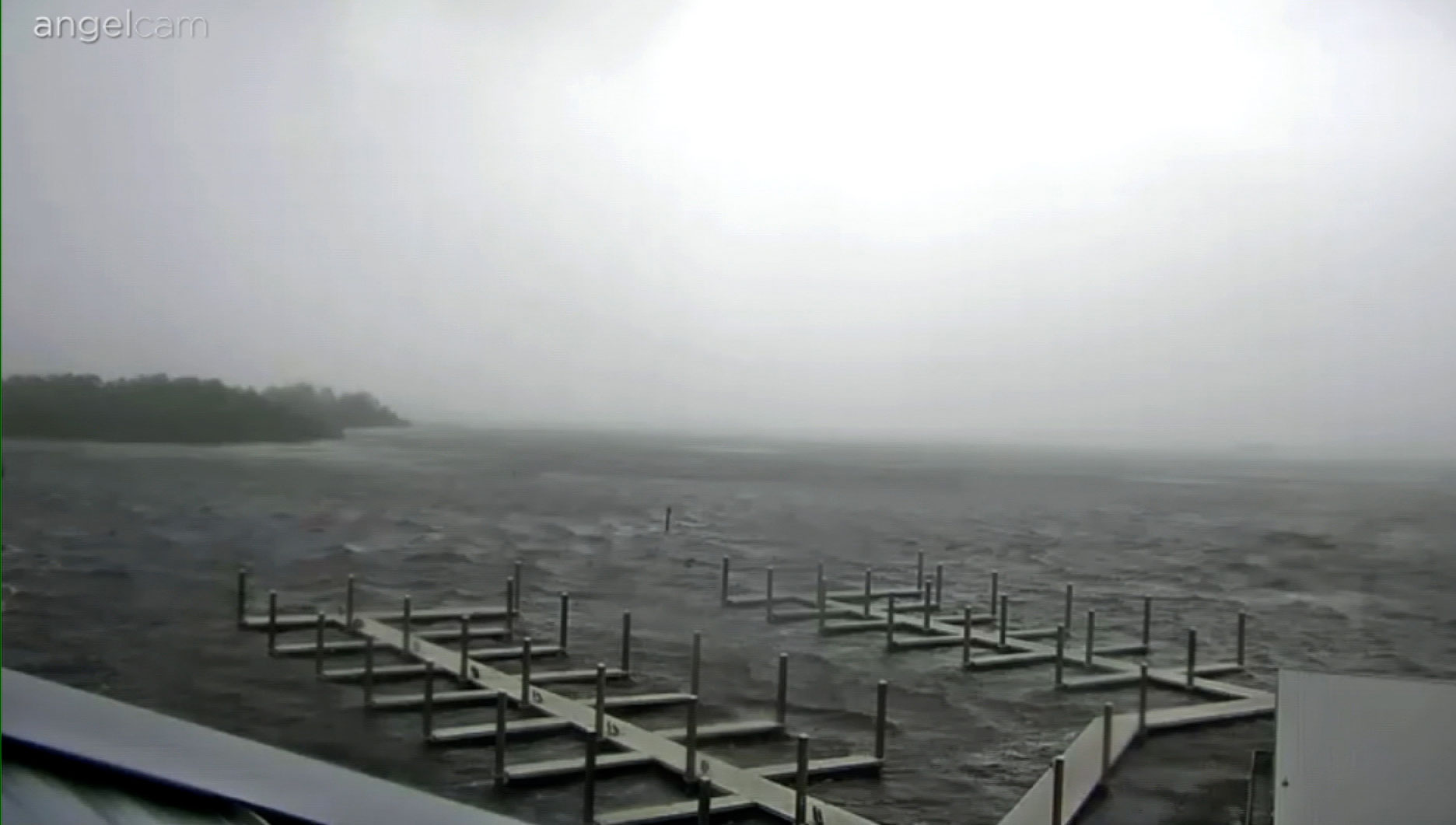
Cedar Key on Florida’s Gulf Coast is experiencing between 8 and 9 feet of storm surge, with waters still rising rapidly even as normal low tide is occurring.

The surge should continue to climb over the next several hours in Florida’s Big Bend region as backside winds push the water level higher and the normal tide also comes in.

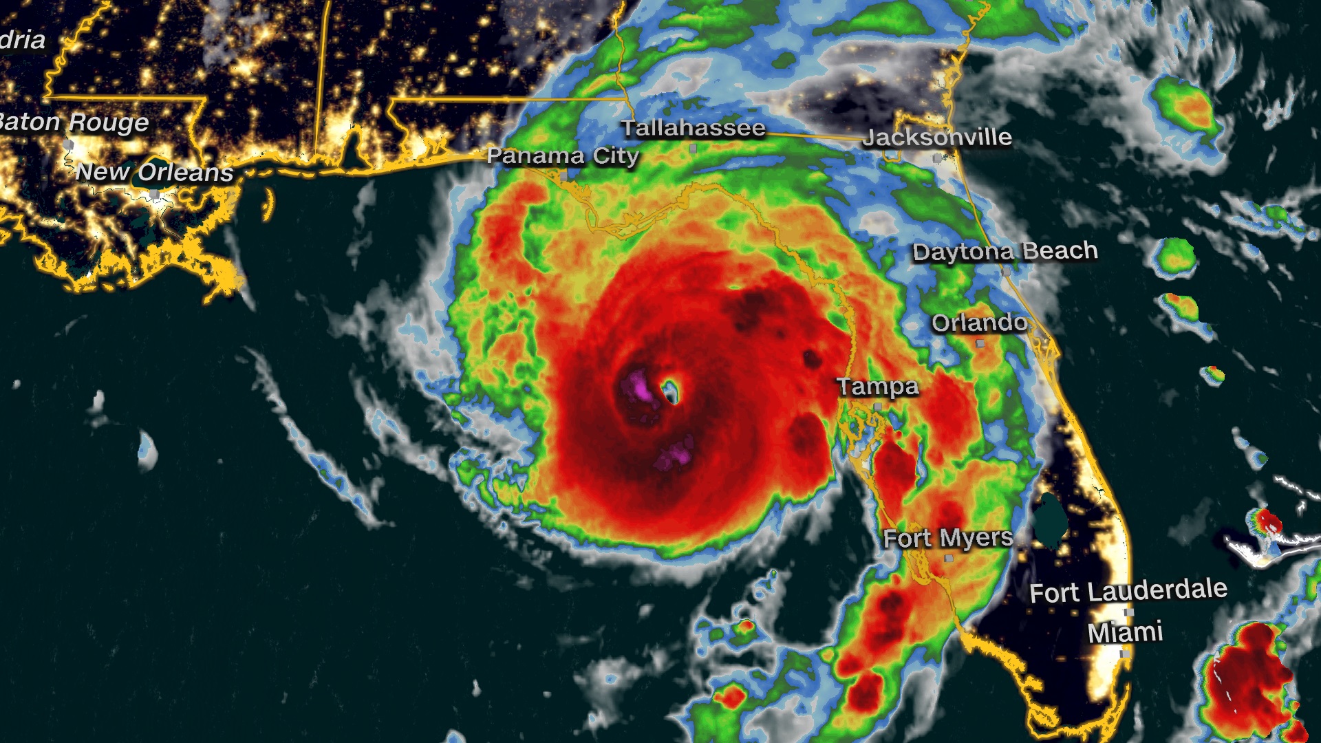
Water levels are nearing 6.5 feet above the highest normal tides, eclipsing a record from Hurricane Hermine in 2016 of 5.99 feet. Water levels have been measured in Cedar Key since 1914. 

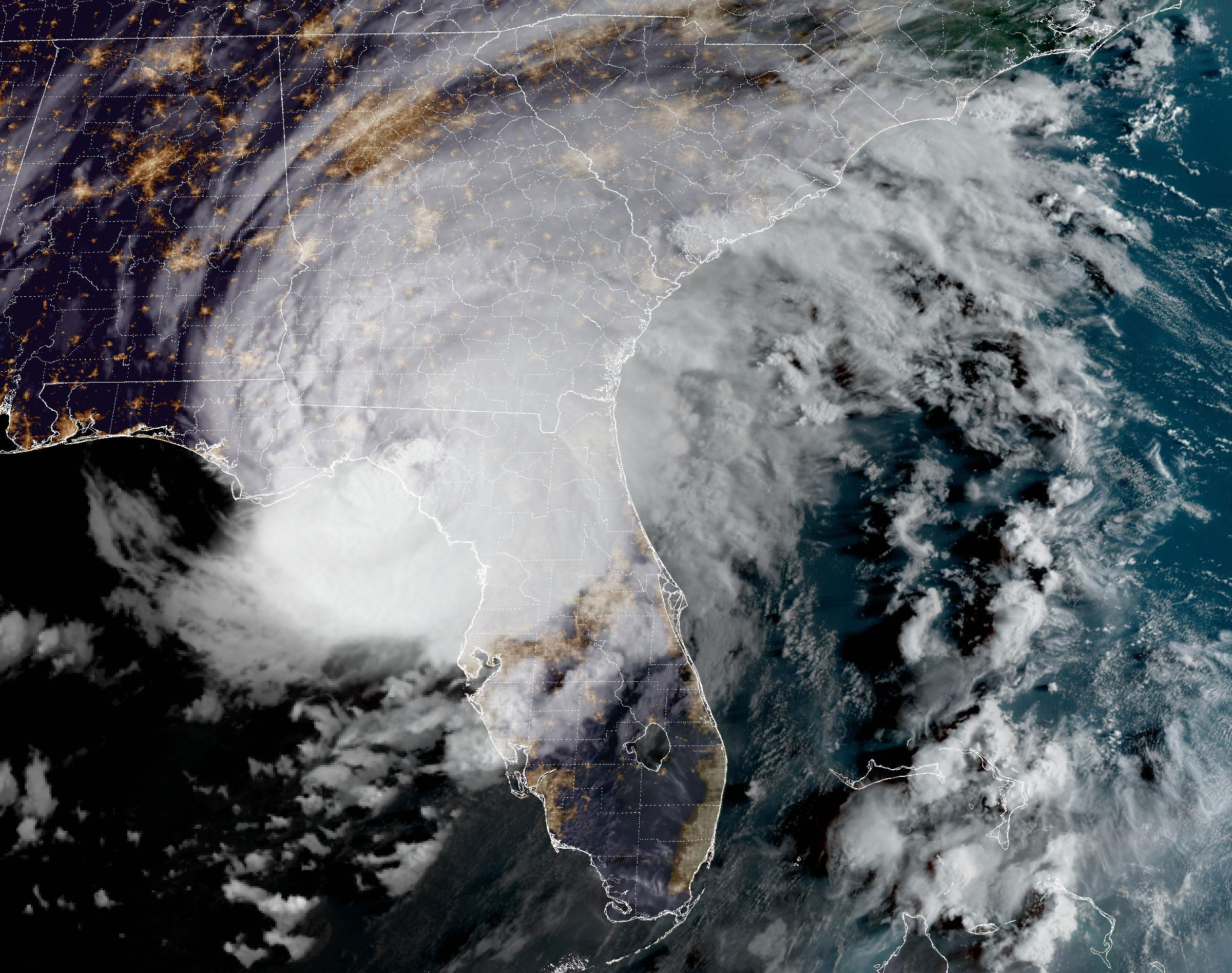
Tidal gauges are sparse across Florida’s Gulf Coast, but the highest water levels on record are occurring in Tampa Bay, Clearwater and Cedar Key — indicating that record storm surge is happening across the wider region.

Here's what makes storm surge so dangerous.

8:05 a.m. ET, August 30, 2023

Hurricane Idalia makes landfall in Florida

Idalia is seen over Florida in this satellite image taken at 7:51am ET on Wednesday.
Idalia is seen over Florida in this satellite image taken at 7:51am ET on Wednesday. NOAA

Hurricane Idalia made landfall near Keaton Beach in Florida’s Big Bend as a Category 3 storm with maximum sustained winds of 125 mph and even higher gusts.

This makes Idalia the strongest storm to make landfall in the Big Bend region in more than 125 years.

Idalia is the third hurricane to make landfall in Florida in the last 12 months, following Hurricane Ian in September 2022 and and Hurricane Nicole in October 2022.

7:46 a.m. ET, August 30, 2023

Biden will address Hurricane Idalia today

From CNN's Betsy Klein

President Joe Biden will address Hurricane Idalia Wednesday afternoon as the Category 3 storm pummels Florida.

Biden, a White House official said, “will deliver remarks on the whole-of-government response and recovery efforts on Maui, Hawaii and the ongoing response from the federal government to Hurricane Idalia.”

Biden and his team have been in close touch with Florida officials, including Gov. Ron DeSantis, as the storm barrels toward the state, threatening devastating damage.

The Federal Emergency Management Agency has pre-positioned resources to respond to the immediate impacts of Idalia. That includes “several Incident Management Assistance teams, Urban Search & Rescue teams, our Disaster Survivor Assistance teams” that “are ready to move to the most impacted areas immediately after the storm passes,” the official said.

FEMA, the official added, “also has warehouses filled with commodities like food, water, blankets, and medical supplies that ready to rapidly move into the impacted area at the state’s request.”

The official noted that the Army Corps of Engineers is pre-positioned for power restoration efforts and the Department of Health and Human Services “assisted with evacuations from hospitals and assisted living centers.” 

Biden speaks at 1:45 p.m. ET in the Roosevelt Room.

10:36 a.m. ET, August 30, 2023

More than 116,000 Floridians without power ahead of Idalia landfall

From CNN's Melissa Alonso

There are about 116,000 Florida customers in the dark as Hurricane Idalia churns closer to the state, according to poweroutage.us

As of 7:25 a.m. ET, the bulk of the outages are in the Big Bend region of the state. This includes Taylor County, with about 13,000 out; Dixie County, with about 10,000 outages; and Levy County, with about 8,000 outages. 

In Wakulla County, located on the Florida Panhandle, about 10,000 customers are without power — which is about 57% of all customers in the county. 

8:49 a.m. ET, August 30, 2023

Here's when and where some areas will feel peak impacts from Hurricane Idalia

From CNN meteorologist Brandon Miller

Rain and wind sweep through the Steinhatchee Marina in Steinhatchee, Florida, on Wednesday morning.
Rain and wind sweep through the Steinhatchee Marina in Steinhatchee, Florida, on Wednesday morning. WCJB

Hurricane Idalia is expected to make landfall very soon northwest of Steinhatchee in Florida's western Big Bend region, with extreme wind warnings in place for destructive tornado-like winds.

But landfall is by no means the end of the story — as seen in Tampa, with major impacts occurring far from the center of the storm. A major surge is happening now in Tampa Bay; it is expected to crest soon but will only recede slowly as high tide isn’t until this afternoon. 

Significant impacts will also occur far inland after the storm makes landfall, with hurricane warnings extended well into Georgia.

We will see this type of surge, and likely worse, in areas farther up the coast like Crystal River, Cedar Key and Steinhatchee, even as the storm passes and the strong backside winds push water onshore.

Idalia is expected to remain a hurricane through the day as it moves into Georgia and over Savannah later this evening. 

Here are some of the cities that will see impacts:

Steinhatchee

  • Timing of tropical storm-force winds: lasting until mid-afternoon
  • Peak storm conditions: happening now through noon today
  • Peak wind gusts: 100 to 115 mph
  • Total rainfall: 2 to 3 more inches
  • Storm surge: 10 to 15 feet, peaking late morning most likely

St. Marks/Apalachee Bay

  • Timing of tropical storm-force winds: now through early afternoon
  • Peak storm conditions: 7 a.m. ET to noon Wednesday
  • Peak wind gusts: 75 to 90 mph
  • Total rainfall: 4 to 6 more inches
  • Storm surge: 12 to 16 feet on right side of the eye, 8 to 12 feet on the left side of eye 

St. Petersburg/Tampa Bay

  • Timing of tropical storm-force winds: now through early afternoon
  • Peak storm conditions: into mid-morning
  • Peak wind gusts: 45 to 55 mph
  • Total rainfall: 1 to 2 more inches inches
  • Storm surge: 4 to 7 feet

Savannah, Georgia

  • Timing of tropical storm-force winds: 5 p.m. Wednesday until after midnight
  • Peak storm conditions: 7 p.m. ET to 10 p.m. ET Wednesday
  • Peak wind gusts: 75 to 95 mph
  • Total rainfall: 2 to 4 inches
  • Storm surge: 2 to 4 feet
7:31 a.m. ET, August 30, 2023

Hurricane Idalia is now a Category 3 storm with 125 mph winds

From CNN meteorologist Brandon Miller

Hurricane Idalia has weakened very slightly before landfall and is now a Category 3 hurricane with 125 mph winds and higher gusts.

This is only down 5 mph from the previous update and does not diminish the dangers the storm presents.

Earlier, the storm intensified into an extremely dangerous Category 4 hurricane with winds of 130 mph before slightly weakening.

“Radar and Air Force Reserve Hurricane Hunter aircraft data indicate that an eyewall replacement cycle has begun,” the National Hurricane Center said. “Idalia's maximum sustained winds are now estimated near 125 mph (205 km/h) with higher gusts. This change in wind speed does not diminish the threat of catastrophic storm surge and damaging winds.”

An eyewall replacement cycle is a natural cycling process strong hurricanes and typhoons go through where a new eye begins to develop inside the eye of the storm. 

Within the past hour, wind gusts of 55 mph have been recorded in Cedar Key and Apalachee Bay.

7:20 a.m. ET, August 30, 2023

A dangerous scenario is playing out for northern Florida and southern Georgia 

From CNN meteorologist Mary Gilbert

A satellite image of Idalia as it heads towards Florida on August 30.
A satellite image of Idalia as it heads towards Florida on August 30. CNN Weather

Idalia is a strong Category 3 hurricane as it nears landfall in Florida’s Big Bend region Wednesday morning, bringing destructive, life-threatening impacts in and around its center.

And the hurricane will retain strength after landfall as it carves a path inland through the southeastern US.

Idalia will still be a powerful hurricane as it tracks through northern Florida through late Wednesday morning and across southeastern Georgia Wednesday afternoon.

Damaging winds will extend well beyond the hurricane’s center during this time and could cause widespread, long-duration power outages for the region.

Tallahassee, Florida, will endure sustained winds of 25 to 35 mph with gusts near 60 mph as the hurricane tracks to the city’s southeast Wednesday morning. Inland areas near the path of Idalia like Valdosta, Georgia, will be slammed by sustained winds of 55 to 75 mph and peak wind gusts up to 110 mph.  

Torrential, flooding rainfall is also possible from Florida’s Big Bend region through parts of Georgia into Wednesday night. Idalia's worst wind and rain will hold off in the Carolinas until late Wednesday and continue into Thursday.  

7:02 a.m. ET, August 30, 2023

Treasure Island "conditions continue to deteriorate," Pinellas County officials say

From CNN's Melissa Alonso

"Conditions continue to deteriorate on Treasure Island," in Pinellas County's coast, city officials cautioned in a Wednesday morning storm update. 

"There’s another high tide at 11:30 a.m. which has the possibility of creating more surge and flooding," said the update.

Treasure Island officials said conditions currently include "storm surge, street flooding, tree limbs down scattered, debris [and] power outages."

"The bridges are closed around Treasure Island," said officials. Treasure Island Police "will be patrolling the Treasure Island Causeway and restricting access to the island," officials said.

Treasure Island is located on a barrier island on the Gulf of Mexico's western coast.

6:57 a.m. ET, August 30, 2023

DeSantis' advice to Florida residents as Idalia nears landfall: "Just hunker down until it gets past you"

WCTV
WCTV

Florida Gov. Ron DeSantis urged Florida residents to heed emergency officials' warnings to take cover as Hurricane Idalia nears the state's Gulf Coast.

"This thing's powerful. If you're inside, just hunker down until it gets past you. You don't want to be messing around with these winds. There's going to be things flying all over the place," he said at a news conference Wednesday morning.

"We just hope everybody stays safe. Don't put your life at risk by doing anything dumb at this point," he added.

DeSantis said that while residents are urged to stay inside and off the streets as Idalia passes over the state, officials will begin search and rescue missions as soon as it's safe to do so.

When those efforts begin, Florida has the following resources ready to go:

  • Eight urban search and rescue teams
  • 33 ambulance strike teams
  • 5,500 national guardsmen

The Coast Guard is also on stand by should they be needed, DeSantis said.