How Hurricane Idalia rapidly intensified to a dangerous Category 4

August 30, 2023 - Idalia makes Florida landfall

By Elizabeth Wolfe, Liz Enochs, Leinz Vales, Adrienne Vogt, Mike Hayes, Elise Hammond and Tori B. Powell, CNN

Updated 12:10 a.m. ET, August 31, 2023
42 Posts
Sort byDropdown arrow
9:27 a.m. ET, August 30, 2023

How Hurricane Idalia rapidly intensified to a dangerous Category 4

From CNN’s Rachel Ramirez

Hurricane Idalia rapidly intensified Tuesday evening into Wednesday morning and maxed out as dangerous Category 4 before weakening slightly ahead of landfall. It did so as it tapped into some of the warmest waters on the planet, and joined a growing list of major storms like Hurricane Ian that rapidly intensified before landfall in recent years.

Rapid intensification is precisely what it sounds like — when a storm’s winds strengthen rapidly over a short amount of time. Scientists have defined it as a wind speed increase of at least 35 mph in 24 hours or less.

Scientists have been alarmed at how warm ocean temperatures have been this year, including in the Gulf if Mexico and around southern Florida, where sea surface temperature climbed to around 100 degrees Fahrenheit earlier this summer.

Average sea surface temperature in Idalia’s path was recently measured at nearly 88 degrees Fahrenheit — a record there since data began in the early 1980s.

In the Gulf overall, ocean temperatures are around “1 to 2 degrees Celsius (roughly 2 to 3.5 degrees Fahrenheit) above normal for this time of year, which is a lot when you consider this is already a super-hot time of year,” Brian McNoldy, an atmospheric scientist at the University of Miami, told CNN. “With that in mind, and with those extra warm waters ahead of it, it does make rapid intensification more likely to happen.”

Idalia did weaken slightly to a Category 3 before landfall, “but too late and not enough to make a difference” in the impacts, McNoldy posted on social media Wednesday morning.

Rapid intensification has been happening to more storms as they approach landfall, making them harder to prepare for and more dangerous to the people who stayed behind expecting a weaker storm.

It’s just one of the ways experts say the climate crisis is making hurricanes more dangerous, as warmer waters allow for storms to strengthen quicker. More than 90% of the planets warming in the past 50 years has taken place in the oceans, according to the National Oceanic and Atmospheric Administration.

9:05 a.m. ET, August 30, 2023

Hurricane Idalia storm surge will crest Alafia River today, officials say

From CNN's Melissa Alonso

Residents along the Alafia River in Florida's Hillsborough County will experience flooding today as it "should crest this morning, and high water may continue through the afternoon," county officials said Wednesday.

"Residents can expect 4 to 6.5 feet of water from the Gulf of Mexico to affect coastal areas," according to a morning update. "Residents along the Alafia River between Gibsonton and U.S. Hwy. 301 face the greatest threat and should expect moderate to major flooding with some flooding up through Riverview due to Hurricane Idalia and storm surge effects."

"Even though skies might look clear on Wednesday morning, it is not time to return home until you receive the all-clear from County emergency management officials," the county said. 

The Alafia River is about 25 miles long and spans from Tampa Bay to Lithia, Florida. 

Some background: A storm surge occurs when winds push water onto shore, accounting for about half of hurricane fatalities between 1963 and 2012, according to a 2014 report in the Bulletin of the American Meteorological Society.

8:54 a.m. ET, August 30, 2023

Tampa mayor: Flooding now "is nothing compared to what we are going to see in a few hours"

Tampa Mayor Jane Castor warned residents to not let their guard down, as more flooding is expected from Hurricane Idalia this afternoon.

"We have had some damage from the winds, downed trees, limbs, those types of things. But what we are mainly concerned with is the same thing that you're experiencing up in Crystal River. We have flooding, extensive flooding along our coast right now. We have 126 miles of waterfront land here in Tampa, and that is only going to rise. We are at low tide. The tide is coming in. We expect that king high tide around noon to 1 (p.m. ET) and that's going to bring in several additional feet of water," Castor told CNN.

"The flooding that we are experiencing now is nothing compared to what we are going to see in a few hours," she said.

She added that two bridges connecting Hillsborough and Pinellas counties are closed until this evening, and both Harbor and Davis islands are inaccessible.

10:24 a.m. ET, August 30, 2023

Here's how Florida residents can hunker down safely during Hurricane Idalia

From CNN staff

As Hurricane Idalia makes landfall in Florida and a tornado watch remains in effect in many areas, CNN Meteorologist Allison Chinchar advises residents who have decided to hunker down in their homes on how to stay safe.

"In a tornado warning your safe spot is the lowest level of your home," Chinchar said. "If your home is taking in flood waters you don't want to go to the lowest level of your home, you want to go to the highest level of your home."

"Your safe place for much of the day today is probably going to be in the middle of that, being in an interior room, somewhere on the mid-level of your home, away from the flood waters but also protecting you from the tornado potential."

Gov. Ron DeSantis urged Florida residents to heed emergency officials' warnings to take cover and "hunker down until it gets past you." 

"You don't want to be messing around with these winds. There's going to be things flying all over the place," he said at a news conference Wednesday morning.

Earlier, a tornado watch went in to effect for nearly 12 million people across central and northern Florida and southeast Georgia until 3 p.m. ET, Wednesday, as conditions continue to deteriorate, with coastal streets and lots flooding in places including Tampa, St. Petersburg and Fort Myers Beach as ocean water pushes ashore, rain pours down and winds whip.

The cities of Tampa, Orlando, Jacksonville and Gainesville in Florida, and Savannah, Georgia are in the watch.

8:33 a.m. ET, August 30, 2023

Cedar Key tide gauge breaks water level record with storm surge and is still rising quickly

From CNN meteorologist Brandon Miller

Cedar Key on Florida’s Gulf Coast is experiencing between 8 and 9 feet of storm surge, with waters still rising rapidly even as normal low tide is occurring.

The surge should continue to climb over the next several hours in Florida’s Big Bend region as backside winds push the water level higher and the normal tide also comes in.

Water levels are nearing 6.5 feet above the highest normal tides, eclipsing a record from Hurricane Hermine in 2016 of 5.99 feet. Water levels have been measured in Cedar Key since 1914. 

Tidal gauges are sparse across Florida’s Gulf Coast, but the highest water levels on record are occurring in Tampa Bay, Clearwater and Cedar Key — indicating that record storm surge is happening across the wider region.

Here's what makes storm surge so dangerous.

8:05 a.m. ET, August 30, 2023

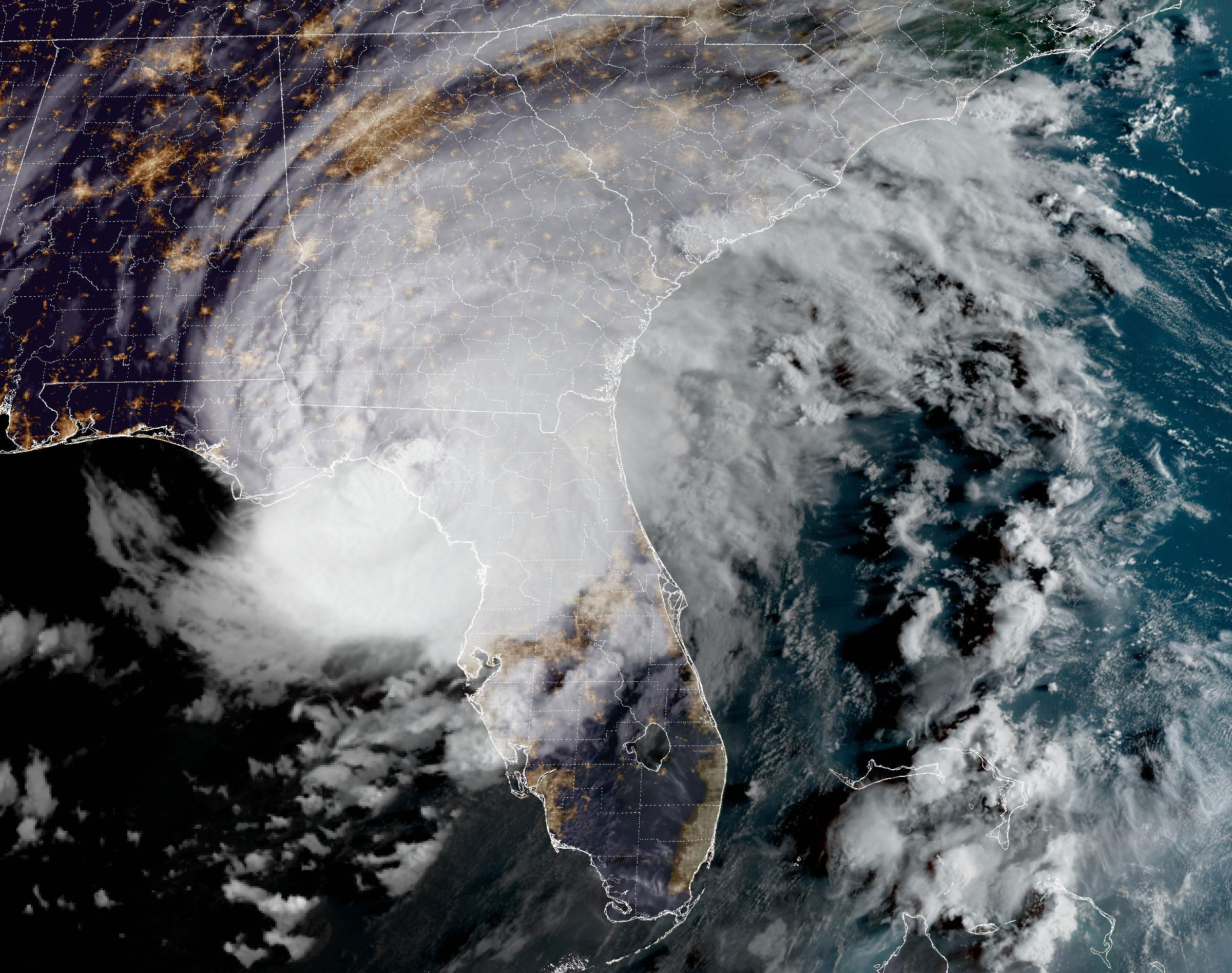
Hurricane Idalia makes landfall in Florida

Idalia is seen over Florida in this satellite image taken at 7:51am ET on Wednesday.
Idalia is seen over Florida in this satellite image taken at 7:51am ET on Wednesday. NOAA

Hurricane Idalia made landfall near Keaton Beach in Florida’s Big Bend as a Category 3 storm with maximum sustained winds of 125 mph and even higher gusts.

This makes Idalia the strongest storm to make landfall in the Big Bend region in more than 125 years.

Idalia is the third hurricane to make landfall in Florida in the last 12 months, following Hurricane Ian in September 2022 and and Hurricane Nicole in October 2022.

7:46 a.m. ET, August 30, 2023

Biden will address Hurricane Idalia today

From CNN's Betsy Klein

President Joe Biden will address Hurricane Idalia Wednesday afternoon as the Category 3 storm pummels Florida.

Biden, a White House official said, “will deliver remarks on the whole-of-government response and recovery efforts on Maui, Hawaii and the ongoing response from the federal government to Hurricane Idalia.”

Biden and his team have been in close touch with Florida officials, including Gov. Ron DeSantis, as the storm barrels toward the state, threatening devastating damage.

The Federal Emergency Management Agency has pre-positioned resources to respond to the immediate impacts of Idalia. That includes “several Incident Management Assistance teams, Urban Search & Rescue teams, our Disaster Survivor Assistance teams” that “are ready to move to the most impacted areas immediately after the storm passes,” the official said.

FEMA, the official added, “also has warehouses filled with commodities like food, water, blankets, and medical supplies that ready to rapidly move into the impacted area at the state’s request.”

The official noted that the Army Corps of Engineers is pre-positioned for power restoration efforts and the Department of Health and Human Services “assisted with evacuations from hospitals and assisted living centers.” 

Biden speaks at 1:45 p.m. ET in the Roosevelt Room.

10:36 a.m. ET, August 30, 2023

More than 116,000 Floridians without power ahead of Idalia landfall

From CNN's Melissa Alonso

There are about 116,000 Florida customers in the dark as Hurricane Idalia churns closer to the state, according to poweroutage.us

As of 7:25 a.m. ET, the bulk of the outages are in the Big Bend region of the state. This includes Taylor County, with about 13,000 out; Dixie County, with about 10,000 outages; and Levy County, with about 8,000 outages. 

In Wakulla County, located on the Florida Panhandle, about 10,000 customers are without power — which is about 57% of all customers in the county. 

8:49 a.m. ET, August 30, 2023

Here's when and where some areas will feel peak impacts from Hurricane Idalia

From CNN meteorologist Brandon Miller

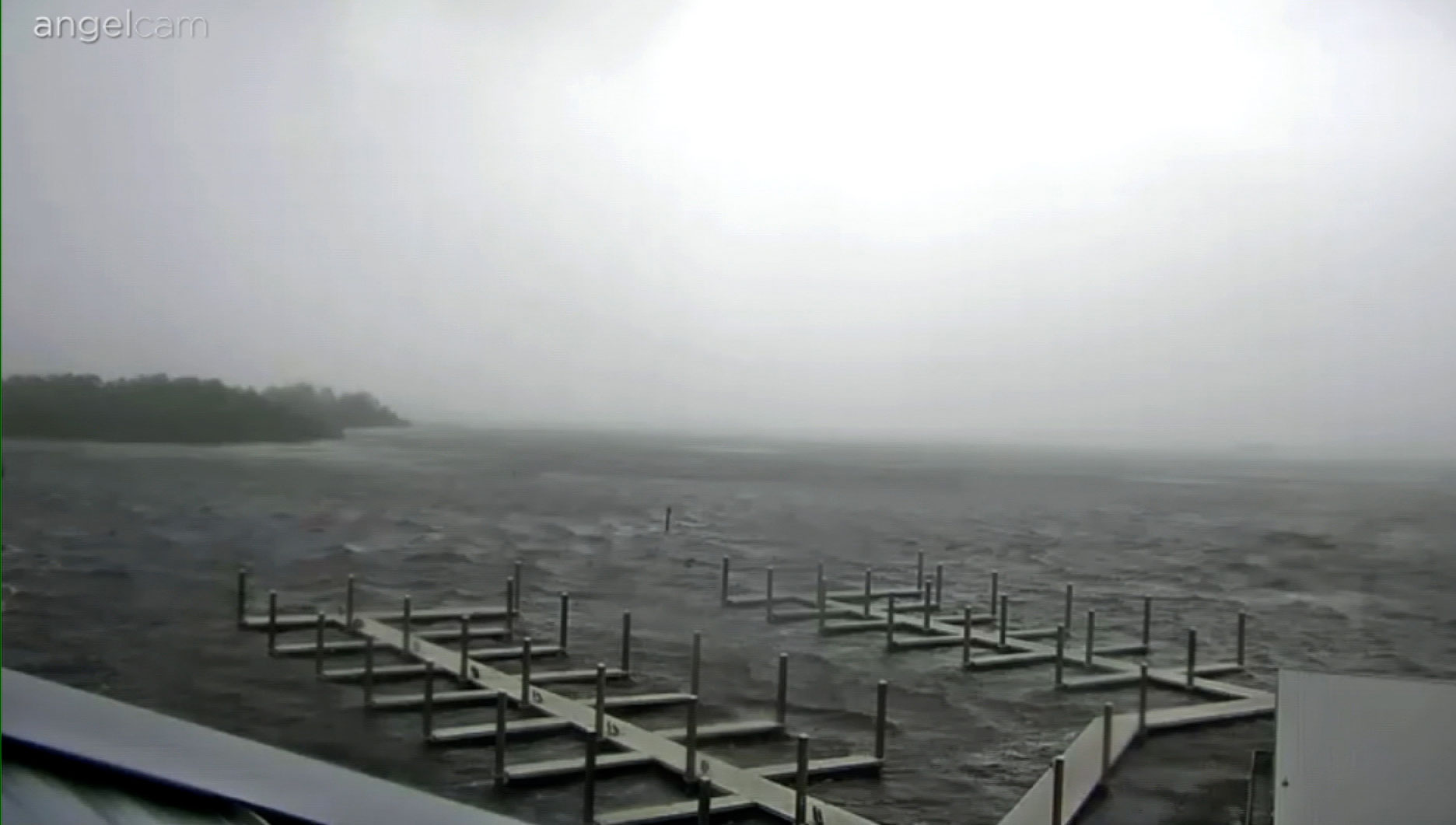
Rain and wind sweep through the Steinhatchee Marina in Steinhatchee, Florida, on Wednesday morning.
Rain and wind sweep through the Steinhatchee Marina in Steinhatchee, Florida, on Wednesday morning. WCJB

Hurricane Idalia is expected to make landfall very soon northwest of Steinhatchee in Florida's western Big Bend region, with extreme wind warnings in place for destructive tornado-like winds.

But landfall is by no means the end of the story — as seen in Tampa, with major impacts occurring far from the center of the storm. A major surge is happening now in Tampa Bay; it is expected to crest soon but will only recede slowly as high tide isn’t until this afternoon. 

Significant impacts will also occur far inland after the storm makes landfall, with hurricane warnings extended well into Georgia.

We will see this type of surge, and likely worse, in areas farther up the coast like Crystal River, Cedar Key and Steinhatchee, even as the storm passes and the strong backside winds push water onshore.

Idalia is expected to remain a hurricane through the day as it moves into Georgia and over Savannah later this evening. 

Here are some of the cities that will see impacts:

Steinhatchee

  • Timing of tropical storm-force winds: lasting until mid-afternoon
  • Peak storm conditions: happening now through noon today
  • Peak wind gusts: 100 to 115 mph
  • Total rainfall: 2 to 3 more inches
  • Storm surge: 10 to 15 feet, peaking late morning most likely

St. Marks/Apalachee Bay

  • Timing of tropical storm-force winds: now through early afternoon
  • Peak storm conditions: 7 a.m. ET to noon Wednesday
  • Peak wind gusts: 75 to 90 mph
  • Total rainfall: 4 to 6 more inches
  • Storm surge: 12 to 16 feet on right side of the eye, 8 to 12 feet on the left side of eye 

St. Petersburg/Tampa Bay

  • Timing of tropical storm-force winds: now through early afternoon
  • Peak storm conditions: into mid-morning
  • Peak wind gusts: 45 to 55 mph
  • Total rainfall: 1 to 2 more inches inches
  • Storm surge: 4 to 7 feet

Savannah, Georgia

  • Timing of tropical storm-force winds: 5 p.m. Wednesday until after midnight
  • Peak storm conditions: 7 p.m. ET to 10 p.m. ET Wednesday
  • Peak wind gusts: 75 to 95 mph
  • Total rainfall: 2 to 4 inches
  • Storm surge: 2 to 4 feet