At least two homes in Studio City damaged by “debris flow”
From CNN’s Amanda Musa
At least two homes in the Studio City neighborhood were left with “significant” damage after being struck by a “debris flow,” the Los Angeles Fire Department said Sunday night.
More than a dozen residents and their pets were evacuated from all nine homes on Lockridge Road, the department said.
“LAPD/EMD are working together to offer emergency shelter locations to residents” if needed, the department said.
Debris flows are “fast-moving landslides” that can occur during periods of intense rainfall, according to the US Geological Survey.
4:37 a.m. ET, February 5, 2024
Hundreds of flights canceled or delayed across California airports
From CNN's Robert Shackelford
A person checks flight information signs at San Francisco International Airport on February 4. Tayfun Coskun/Anadolu/Getty Images
Flight delays and cancellations are mounting across major California airports as an atmospheric river-fueled storm lashes the state on Sunday night.
Here are the latest, according to FlightAware:
San Francisco International Airport (SFO)
Canceled: 215+
Delayed: 380+
Los Angeles International Airport (LAX)
Canceled: 40+
Delayed: 575+
Sacramento International Airport (SMF)
Canceled: 45+
Delayed: 115+
San Diego International Airport (SAN)
Canceled: 25+
Delayed: 210+
Metro Oakland International Airport (OAK)
Canceled: 30+
Delayed: 95+
2:22 a.m. ET, February 5, 2024
Here's the latest storm impact across California as winds hit up to 100 mph
From CNN's Robert Shackelford
A person rides a bike through floodwaters during a storm in Santa Barbara, California, on Sunday, Februar 4. Eric Thayer/Bloomberg/Getty Images
The Weather Prediction Center has been compiling rainfall reports from the powerful atmospheric river impacting much of California.
Here are the latest rainfall totals:
Matilija Canyon: 5.91 inches
El Deseo: 5.61 inches
Old Man Mountain: 5.67 inches
San Francisco International Airport: 1.29 inches
Downtown Los Angeles: 1.18 inches
Flood watches remain in effect for nearly 40 million people across California through the day on Monday. The number of customers experiencing power outages is currently around 770,000, according to PowerOutages.us.
Rainfall totals of 4-8 inches are expected across Southern California with isolated totals of 8-14 inches across mountains and foothills.
Here's a look at some updated high-wind reports:
Lagunitas-Forest Knolls: 102 mph
Santa Clara: 98 mph
Oakland International Airport: 60 mph
San Francisco International Airport: 58 mph
Sacramento Airport: 46 mph
1:46 a.m. ET, February 5, 2024
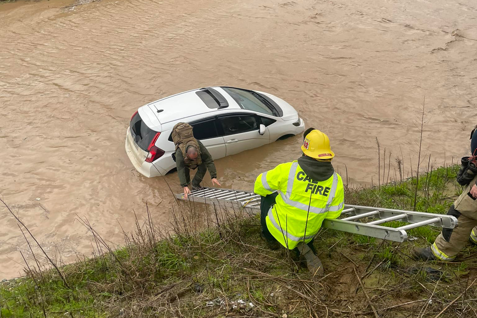
Man saved from high waters in central California
From CNN's Amanda Musa
Firefighters rescue a man caught in high waters in Nipomo, central California, on Sunday. County of San Luis Obispo Government/Facebook
Firefighters rescued a man caught in high waters on Sunday in the town of Nipomo in central California.
A photo posted to the County of San Luis Obispo’s Facebook page shows a man climbing a ladder to safety with a car partially submerged in flood water behind him.
“While the storm is supposed to lighten up a bit tomorrow we still may see some flooding. Please don’t try to drive through any standing water,” the post reads.
1:37 a.m. ET, February 5, 2024
Rock and mudslides hit canyon roads in and out of Malibu
From CNN's Taylor Romine
All canyon roads going in and out of Malibu in Southern California have been hit by rock and mudslides, the Los Angeles County Sheriff's Department said in a social media post on Sunday.
"Currently, Malibu Canyon Road is closed between Malibu Crest and Mulholland Highway," the post said. "Traveling on other routes (Kanan Dume Road, Topanga Canyon, etc.) is not advisable."
1:43 a.m. ET, February 5, 2024
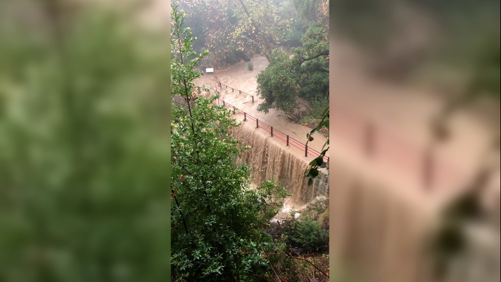
Santa Barbara Botanic Garden inundated by Mission Creek floods
From CNN's Taylor Romine
The Santa Barbara Botanic Garden shared a video of a flood on their property Sunday as a severe storm system hit the state.
"The heavy rainfall has created a captivating sight, as water from Mission Creek cascades over the historic dam," the garden said in a Facebook post.
So far, there is no damage to the garden, according to the post. The grounds crew and volunteers are preparing trails and areas along the creek.
Flash flood warnings will remain in place for the Californian counties of Ventura and Santa Barbara until midnight local time.
1:00 a.m. ET, February 5, 2024
It's 10 p.m. on the West Coast. Here’s the latest forecast for major cities
From CNN's Robert Shackelford
Strong winds and heavy rainfall across much of California are expected to continue for the next couple of days.
More than 900,000 people have been without power in the state and flash flood warnings remain in place in several areas, including the southeastern counties of Santa Barbara and Ventura.
Here is a city-by-city forecast for major cities across California and what is expected during the morning commute on Monday:
Los Angeles
Alert: Flash flood warning until midnight local time Monday and flood watch until 4 p.m. local time Tuesday.
Peak rainfall: Begins now until midnight local time Monday.
The greatest risk for life-threatening flash flooding is from late on Sunday through morning rush hour tomorrow.
Wind speeds: A wind advisory is in place until 6 a.m. PT on Monday with20-25 mph, and gusts of 25-35 mph, now until 7 a.m. PT on Monday.
Rainfall total: 4-8 inches
Expected forecast for Monday morning commute: Rainfall will be ongoing with isolated heavy pockets at times. Water should still be on roadways and driving is not advised.
San Francisco
Alert: Flood watch until 10 a.m. local time on Monday.
Wind Speeds: A wind advisory is in place until 10 p.m. local time Sunday with speeds of 20-30 mph and gusts of 40-50 mph.
Peak rainfall: From now until 6 a.m. local time on Monday with showers expected to linger through Tuesday.
Wind speeds: 20-30 mph, gusts of 40-50 mph.
Rainfall total: 2-3 inches
Expected forecast for Monday morning commute: Rainfall will be winding down but roadways may still have standing water.
San Diego
Alert: Flood watch from 4 p.m. local time on Monday to 10 a.m. PT on Wednesday.
Wind speeds: A wind advisory is in place from 8 p.m. local time Sunday to 11 a.m. local Monday with gusts up to 35 mph.
High surf: A southwest swell from 240 degrees of 8-12 feet with a 9-12 second period will generate high surf. Surf in Orange County will be 4 to 8 ft. Surf in San Diego County will be 6 to 10 ft. The highest surf will be on southwest-facing beaches.
Peak rainfall: Begins at 7 p.m. local time on Monday until 3 a.m. local on Wednesday.
Rainfall total: 2-2.5 inches
Expected forecast for Monday commute: Scattered showers are expected but driving conditions are not expected to be as hazardous here compared to other major cities.
Fresno
Alert: Flood watch until 4 a.m. local on Tuesday.
Peak rainfall: Begins now and lasts until 2 a.m. local time on Tuesday.
Wind speeds: 20-25 mph, gusts of 30-40 mph.
Rainfall total: 1-2 inches
Expected forecast for Monday commute: Scattered showers are expected but driving conditions are not expected to be as hazardous here compared to other major cities.
Sacramento
Alert: Flood watch until 4 a.m. local time Tuesday.
Peak rainfall: Now and lasts until 8 p.m. local time Monday.
Wind speeds: 30-40 mph, gusts of 45-55 mph.
Rainfall total: 2-3 inches.
Expected forecast for Monday morning commute: Rainfall will be winding down but roadways may have excess standing water due to heavy rainfall peaking overnight.
Eureka
Alert: Wind advisory is in place from 1 a.m. local time Monday to Monday to 8 a.m. local on Monday.
Peak rainfall: Begins now and lasts until 6 p.m. ET Monday.
Wind speeds: 15-25 mph, gusts of 30-50 mph.
Rainfall total: 1-1.5 inches
Expected forecast for Monday morning commute: Rainfall and gusty winds are expected, which can lead to travel delays impacts.
12:45 a.m. ET, February 5, 2024
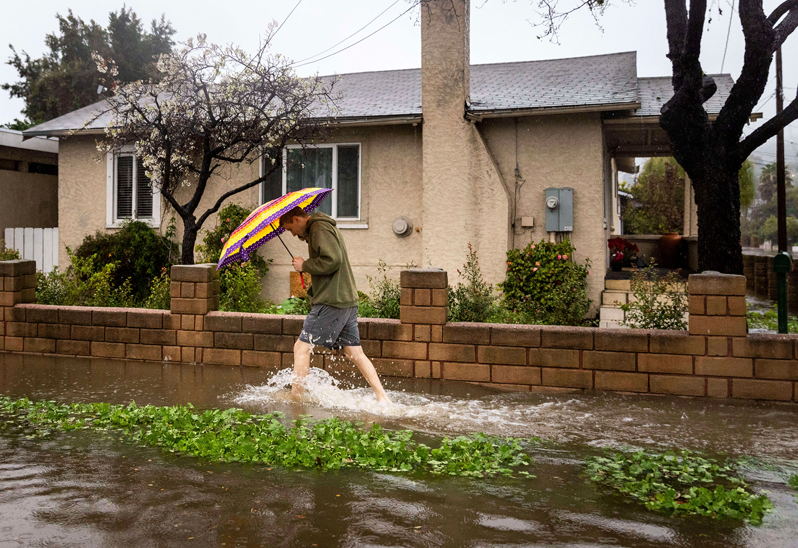
"Extremely dangerous flood situation" unfolding in Ventura County
From CNN's Robert Shackelford
A pedestrian walks through floodwaters during a rainstorm in Santa Barbara, California on February 4. Ethan Swope/AP
Flash flood warnings remain in place for the Californian counties of Ventura and Santa Barbara until midnight local time (3 a.m. ET).
A flash flood warning from the National Weather Service (NWS) said that an "extremely dangerous flood situation is unfolding for the mountains and foothills of central Ventura County."
"At 836 PM PST, local law enforcement reported numerous flooded roads, vehicles submerged, rock and mud slides, and quickly rising levels of area rivers. Between 3 and 7 inches of rain have fallen," the NWS Los Angeles warned. "Additional rainfall amounts of 1 to 4 inches are possible in the warned area overnight tonight, focusing eastward into Ventura County. Flash flooding is already occurring."
There is a risk of life-threatening flash flooding of creeks and streams, urban areas, highways, streets and underpasses. Debris flows are also expected consisting of rock and mudslides, the advisory said.
Some locations that NWS said could experience flash flooding include: Oxnard, Thousand Oaks, Simi Valley, Ventura, Santa Barbara, Camarillo, Fillmore, Ojai, Montecito, Chatsworth, Santa Ynez, Moorpark, Santa Paula, Port Hueneme, Carpinteria, Solvang, La Conchita, Rose Valley, Rincon Point and Ventura Harbor.
11:51 p.m. ET, February 4, 2024
Orange County issues evacuation warnings for some canyon areas
From CNN's Taylor Romine
Evacuation warnings were issued in Orange County on Sunday evening as a storm hit the area.
Effective from 7:00 p.m. PT, voluntary evacuation warnings were issued for Silverado Canyon, Williams Canyon, Modjeska Canyon and Trabuco Canyon, according to a government statement.
Residents in the canyon areas were strongly encouraged to evacuate, especially those with disabilities, access or functional needs, and with large animals.
A map of the areas under the voluntary evacuation warning is viewable on the Orange County Sheriff's site.