What we're covering
• The third winter storm in a week is dumping snow on parts of the central US and is poised to deliver the first widespread snow of the season to the Northeast and New England.
• The storm will strengthen rapidly into a bomb cyclone as it moves up the East Coast Tuesday, with winds intensifying in coastal New England Tuesday night.
• Cities such as Philadelphia, New York and Boston along the Northeast’s highly populous I-95 corridor are likely to miss out on big snow, but could see flakes fly in the morning.
• It’s already cold, but even colder, record-breaking temperatures are possible in the wake of the storm east of the Rockies.
“Steady snow” expected in Chicago through evening
“Steady snow” is expected in Chicago through Monday evening, according to the National Weather Service.
The snow is expected to end between midnight and 2 a.m. Tuesday, the weather service noted.
Up to half an inch of snow per hour is predicted, making for reduced visibility and snow-covered roads.
Motorists are advised to “take it slow if traveling.”
Storm will miss the "magic" mark for big snow along the I-95 corridor
The Interstate 95 corridor from Boston to Philadelphia will mostly see a cold rain instead of snow. And there’s “one weird trick” behind that forecast.
There’s a “magic” spot on the map called the “40/70 benchmark” that is a meteorological rule of thumb for big snowstorms along the I-95 corridor.
It’s where 40 degrees north latitude intersects with 70 degrees west longitude — about 215 miles east of New York City in the Atlantic Ocean. Historically, when cold air is around and a storm tracks across this spot, then the Northeast urban corridor is in a favorable position to receive significant snow.
Tuesday’s storm will track just west of the magic spot. When that happens, it’s a disappointment for East Coast snow lovers since that path tends to draw warmer Atlantic air into the coast, resulting in a rainstorm.
Storms that track outside, or east, of the benchmark can also subdue snow chances in the Northeast by keeping a storm too far offshore.

A little snow causes a lot of trouble on St. Louis roads
A quick 1-3 inches of snow coated the roadways in St. Louis on Monday afternoon, but it was enough to cause serious traffic disruption. Interstates and side streets became gridlocked after numerous crashes were reported.
Video shows first responders tackling multiple accidents on Interstate 44, including one involving a school bus which slid off the road into a ditch. No injuries were reported from the bus accident.
Snow is expected to taper off this evening but authorities are urging motorists to stay off the roads if possible.

A blast of brutal cold will arrive on Wednesday
Dangerous cold will send temperatures plummeting for millions in the US in the latter half of the week. It all starts Wednesday in the north-central US when Arctic air plunges across the northern border.
Temperatures later Wednesday could end up close to 30 degrees below normal for early December, especially in the Dakotas and parts of the Midwest.
The cold will reach life-threatening levels by Thursday morning, if not earlier. Dozens of cold records could be broken in the northern US from Thursday morning through Friday.
Low temperatures will reach into the teens below zero in parts of the Dakotas, Minnesota and Iowa with near-zero temperatures in surrounding states.
Brutally cold overnight lows will expand east for Friday morning. The air temperature in Chicago could be near zero with wind chills in the single digits below zero.
One reason the Northeast's major cities will mostly miss out on snow
It’s difficult for snow to accumulate in major cities like Washington, DC, Philadelphia, New York City and Boston with an early-season storm track like this one’s.
That’s because the storm will likely have too much warm air to deal with along and east of the Interstate 95 corridor to create enough snow to stick. Warmer, moist Gulf air flowing north is part of the problem, along with the influence of warm water just off the Atlantic coast.
A few snowflakes could briefly flutter through the air in the early morning for these metros — or mix with rain — but any illusions of a winter wonderland will shatter once the rain begins.
Where'd all these winter storms come from? Blame the polar vortex
The winter storms hitting the US this week and forecast to occur during the next couple of weeks, can be tied in large part to the displacement of the polar vortex that occurred beginning in late November, researchers tell CNN.
The polar vortex is a circular current of strong winds over the Arctic that can keep cold air locked up in that region. Recently, though, it weakened and slid southward towards the midlatitudes, bringing cold, Arctic air to heavily populated areas.
This can create stormier conditions, said Andrea Lopez Lang, a meteorologist at the University of Wisconsin at Madison, as that cold air from up north collides with relatively warmer air.
And the weak polar vortex also means a wavier jet stream. These are wind currents that flow west-to-east across the Northern Hemisphere. A wavy jet stream can give people weather whiplash, said Judah Cohen, a meteorologist at MIT. Over the rest of December, we can expect frequent oscillations between milder-than-average conditions and frigid temperatures as storms move through.
However, Lopez Lang cautioned this polar vortex event isn’t the only factor behind those upcoming temperature fluctuations. “It’s definitely contributing, but it’s not the whole story,” she said.
Here's where the storm is now

The storm is steadily moving east this afternoon. Snow just recently began in Chicago and is now stretching into parts of Michigan and Indiana. It’s still snowing in parts of Iowa, Missouri and Kansas too.
Some icy mix is still impacting northern Arkansas and approaching western Tennessee.
Snow will continue to expand east into the overnight hours.
The Atlantic Ocean helps explain why snow will miss major Northeastern cities
Major East Coast cities aren’t likely to get accumulating snow from this storm and part of the reason has to do with the still-warm Atlantic.
Huge bodies of water such as the Atlantic are heat sinks that are very slow to cool off even as temperatures plummet over land. Warmer water keeps the air above it warmer, too.
Any storm that feeds from or moves over that warmer air can’t generate as much frozen precipitation such as snow or ice.
Areas farther inland – especially mountainous ones – are cut off from the coastal influence and are able to stay colder, leaving the door open for more snow.
Snow is underway in Chicago
A new batch of snow has begun in Chicago. Both of the city’s major airports are currently reporting light snow. Fortunately, only about an inch or two of snow is expected for the city through tonight.
There’s still snow on the ground in Chicago after the city picked up 8.4 inches on Saturday. It was the single snowiest November day recorded at O’Hare, the city’s official reporting station.
How much snow has fallen so far?
Here’s a look at the latest snow amounts reported to the National Weather Service as of 2:50 p.m. CT.
• Top total: 14 inches in the southwest Colorado Rockies.
• Kansas City: 2 to 4 inches across the metro area.
• St. Louis: 2.3 inches in the northern suburb of Hazelwood.
• Omaha and Lincoln, Nebraska: A dusting to 1.5 inches
St. Louis police respond to “numerous calls for crashes” as snow falls in metro area

Police in St. Louis are responding to “numerous calls for crashes” as snow continues to fall in the metro area, authorities said in a social media post.
The crashes are reported along highways and intersections.
Police are advising motorists to “slow down” and “give yourself plenty of room.”
Authorities also said that roadway conditions are deteriorating rapidly and asked residents to avoid travel if possible, police said in another post.

Traffic maps from the Missouri Department of Transportation show numerous road closures throughout the state. Images from the agency show traffic backups and authorities responding to crashes on roadways covered in snow.
“Roadways have become very slick across much of the region where snow has already fallen,” the National Weather Service in St. Louis said on X. “If snow has not yet begun in your area, be advised that conditions will quickly deteriorate once snow begins.”
Winter weather alerts stretch more than 1,500 miles
Here's what today's storm looks like from space
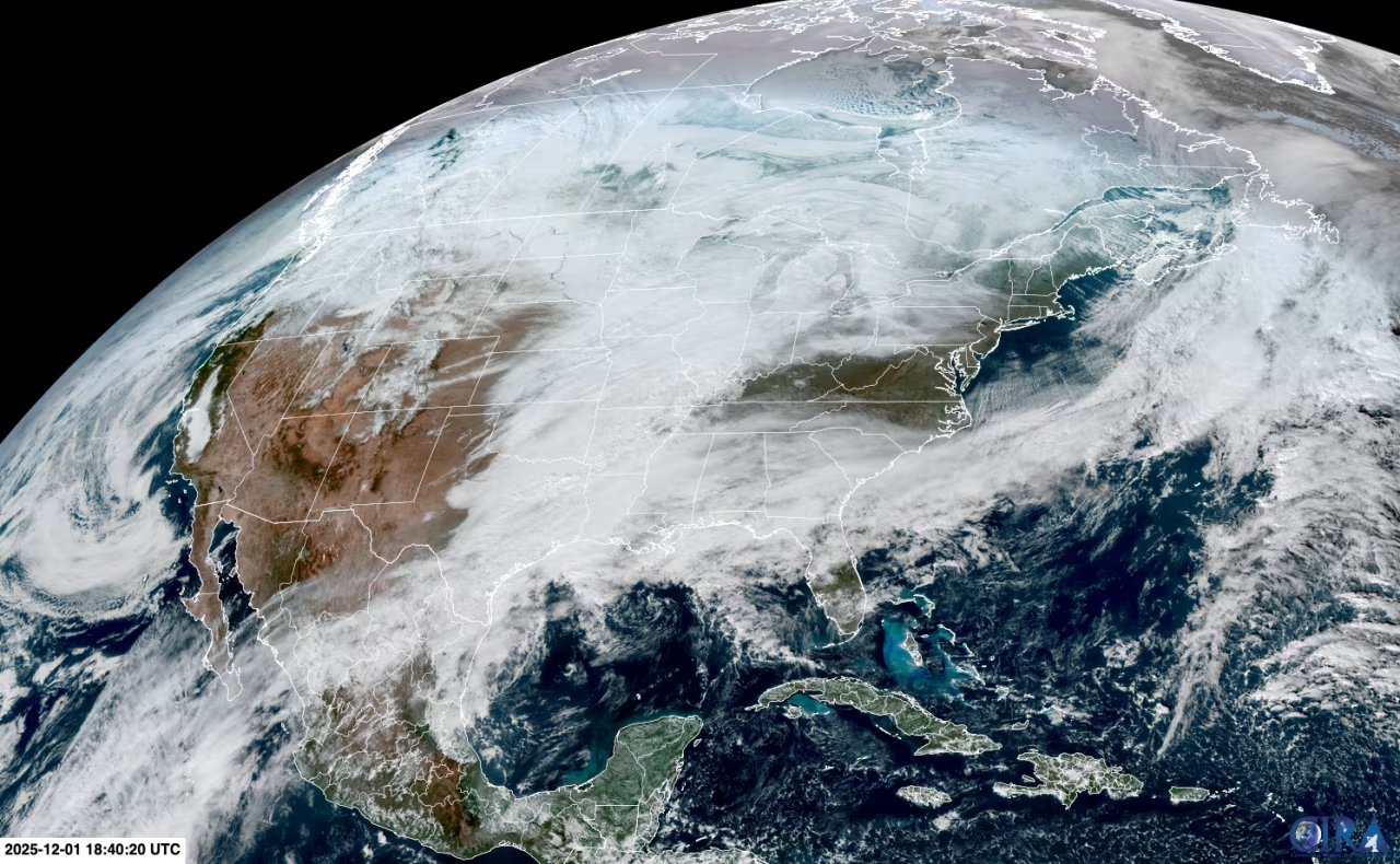
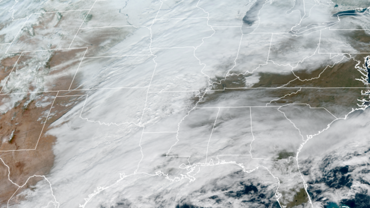
This satellite image captures the huge shield of clouds from the winter storm that stretches from the Gulf to Canada.
Stormy weather is spreading over a significant portion of the central US this afternoon. Snow is falling from Missouri north into parts of the Great Lakes while rain soaks portions of the Gulf Coast.
What’s left of the storm that blew through the eastern half of the country this weekend can be spotted too. It’s the line of clouds that stretches from out near Canada’s Newfoundland Province all the way back to the Southeast.
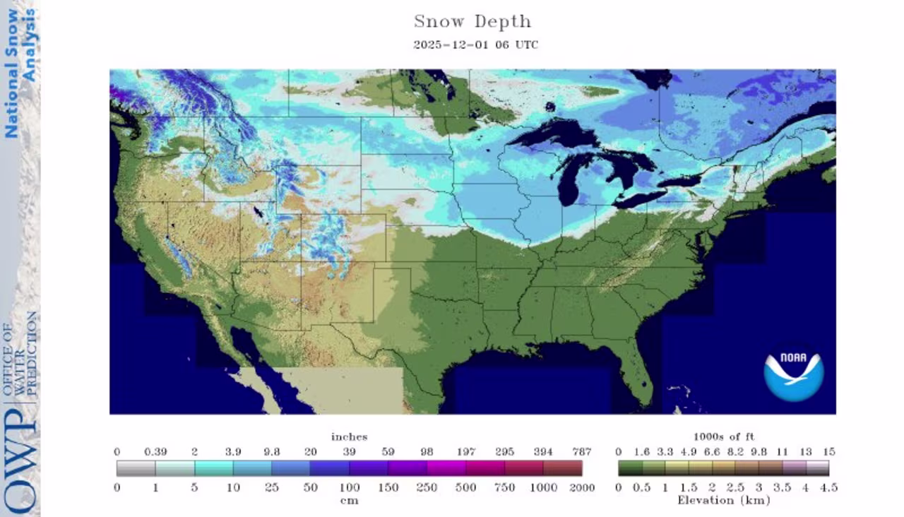
One-third of the US is covered by snow
There’s more snow on the ground across the Lower 48 than there has been in the last six years to kick off meteorological winter.
Meteorological winter begins on December 1 and a cold and stormy finish to November pushed snow cover for the date to 33.4% as of Monday morning, according to a NOAA analysis.
The last time there was this much snow on the ground on December 1 was 2019 when 41% of the Lower 48 was covered – that’s also the most in just over two decades of NOAA records.
Snow cover could grow even more expansive by Tuesday or Wednesday morning depending on how much snow melts and how much new snow falls in the Plains, Midwest and Northeast from the ongoing winter storm.
Maine braces for the first significant snow of the season
Officials in Maine are urging preparedness as an approaching winter storm threatens to bring the season’s first big snow.
“When people wake up Tuesday morning, conditions may appear calm — but by the afternoon and evening, travel is expected to become hazardous,” Vanessa Sperrey, Public Information Officer for the Maine Emergency Management Agency (MEMA).
A winter storm warning is in effect from Tuesday morning into early Wednesday morning that includes Portland and Bangor. A half-foot or more of snow is possible in most areas of eastern Maine. Strong winds could gust up to 35 mph, especially near the coast.
Widespread power outages are not expected, according to Sperrey, but travel conditions could be difficult.
“MEMA is encouraging residents to be prepared: ensure your emergency car kit is stocked and avoid travel when road conditions deteriorate, have weather alerts enabled on smartphones, and pay attention to any instructions from local authorities,” said Sperrey.
Chicago's snow will hit the afternoon commute
This storm won’t be a blockbuster for the Windy City, but it will be ill-timed.
Snow is forecast to reach Chicagoland around 3 to 4 p.m. CT, or right around the start of the afternoon commute. Steady snowfall will then continue well into the evening hours, with a storm total between 2 to 4 inches expected.
Those with travel plans into the evening hours should pencil in some extra time and plan on hazardous conditions, especially on secondary roads.
Snow will end well before the Tuesday morning commute, but untreated surfaces could remain slippery or snow covered.
Heavy snow is falling in St. Louis
Flakes are flying in St. Louis for the second time in three days as the winter storm moves in.
Snow started in the area a little over an hour ago but is starting to pick up steam. Weather observations at St. Louis Lambert International Airport reported a period of heavy snow a few minutes ago.

Up to 3 inches of snow are forecast from the storm. The city recorded 6.4 inches of snow on Saturday.
Where the storm will pile on to record November snow
Chicago, Madison, Wisconsin, and Springfield, Illinois, are set for another burst of snow just two days after all three locations had their record-snowiest November day.
Of those cities, Chicago and Springfield, Illinois, will see the most snow, picking up another 2 to 4 inches in the afternoon and evening hours. More than 8 inches fell in both locations on Saturday.
Madison, Wisconsin, will only get a glancing blow of up to an inch of new snow. That should give shovelers a needed break after a November daily record of 9.3 inches of snow fell on Saturday, pushing its two-day total close to a foot.
Where the storm is now
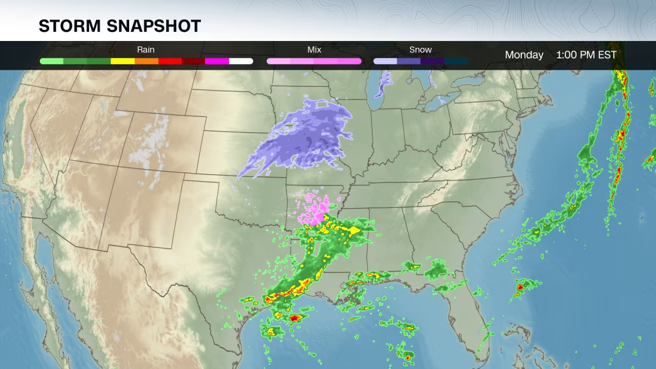
Now: Wintry weather is underway in the central US. It’s snowing in parts of Iowa, Kansas and Missouri with an icy mix in Arkansas. Some snow is also starting to reach into Illinois. Rain is falling in parts of Texas and the lower Mississippi Valley.
This storm will become more organized through the rest of the day and spread snow, rain and an icy mix farther east.
What’s next: Snow will move over the Midwest Monday night and reach the Northeast by early Tuesday morning. Snow will continue in the Northeast for much of the day, mainly west of the region’s major metros. Some icy conditions are possible in parts of the Appalachians Tuesday morning, especially in West Virginia, Virginia and Maryland. Rain will soak much of the Southeast and parts of the mid-Atlantic.
This storm could eventually "bomb out." Here's what that means
The same storm currently taking shape in the center of the country is expected to strengthen significantly once it moves off the East Coast on Tuesday afternoon and become a bomb cyclone not long after.
A bomb cyclone is a rapidly strengthening storm that undergoes a significant drop in pressure – one measure of a storm’s strength – in a short time.
A storm’s pressure must drop at least 24 millibars (a unit of pressure) in 24 hours or less to undergo bombogenesis or “bomb out” and meet the bomb cyclone criteria. Technically, the exact millibar drop needed varies slightly based on the storm’s exact latitude, but 24 millibars in 24 hours is the accepted threshold.
Several weather forecast models are currently projecting the storm’s pressure drop to be between 27 and 29 millibars in 24 hours from Tuesday to Wednesday.