August 31, 2023 Tropical storm Idalia news | CNN

Live Updates

August 31, 2023 Tropical storm Idalia news

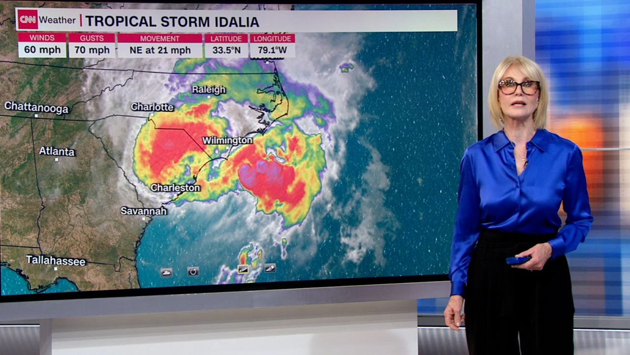
karen mcginnis forecast idalia 08312023
Here are the areas Idalia is set to impact next
02:00 - Source: CNN

What we covered here

  • Idalia remains a tropical storm as it moves into the Atlantic after bringing heavy rain and wind to northwestern Florida, southern Georgia and the Carolinas.
  • President Joe Biden said that he will travel to Florida on Saturday and pledged long-term support to hard-hit communities.
  • Idalia made landfall early Wednesday on Florida’s Gulf Coast as a powerful Category 3 storm. It was the strongest hurricane to hit the Big Bend region, the nook between the panhandle and peninsula, in more than 125 years.
  • The storm is causing flooding in some areas and more than 150,000 customers are without power in the Southeast.

Our live coverage for the day has ended. Follow the latest Idalia news here – or scroll through the updates below.

32 Posts

Florida business owner says he expected a fierce storm because Gulf water has been so unusually warm

Small business owners along a commercial street in Crystal River, Florida, are cleaning up a day after Hurricane Idalia swept through the area.

Anthony Altman, who owns EXPLORIDA, an ecotourism company that offers manatee and scalloping tours, was hard at work Thursday cleaning the inside of his shop, which sustained water damage.

Altman told CNN he prepared well ahead of the storm after seeing the weather forecast and realizing his business would likely be in its path.

“The Gulf of Mexico is 92 degrees. We have scallop tours out there every day and we knew the gulf temperature was going to be (a) very warm environment, because the storm that popped up very fast was coming toward the ocean. We knew this storm was going to be very large,” Altman said. 

Faced with the possibility of losing his business, Altman said he rented a truck and moved his merchandise out before the storm arrived. That move likely saved him thousands of dollars in lost property, and he said he was able to “minimize most of the damage.”

Altman, who has lived and worked in the Crystal River area for several years, said he’d been shocked to see just how much the temperatures in the gulf had risen this summer. 

“We were at the end of summer and the Gulf temperature was 92 degrees. It’s happened in the past, but this year was the hottest it’s been in my lifetime at this time of year. So we knew that this was going to be maybe a very aggressive storm,” Altman said.  

He and his employees hope to reopen soon. 

FEMA administer briefed Biden while on the ground in Florida, spokesperson says

Federal Emergency Management Agency Administrator Deanne Criswell briefed President Joe Biden by phone while surveying damage from Hurricane Idalia, FEMA spokesperson Jeremy Edwards said in a statement.

“While surveying damage in Florida caused by #Idalia, @FEMA Administrator Criswell briefed @POTUS over the phone about the situation on the ground & provided an update on response efforts,” Edwards wrote in the post on X, which included a photo of Criswell on the ground in Florida. “This Saturday, she will be with POTUS when he comes to see the devastation firsthand.”

Biden directed Criswell to travel to Florida after Idalia made landfall Wednesday.

The president announced Thursday that he will travel to the area this weekend while thanking FEMA employees at DC headquarters for their response.

Residents say they have power but no running water on Florida island hit hard by Idalia

Residents spent Thursday clearing piles of debris from homes and businesses in the hard-hit island town of Cedar Key, Florida, starting the long recovery after it was pummelled by Hurricane Idalia.

Residents were allowed to return on Wednesday. They said electricity has been restored but there is no running water. The temperature felt like 97 degrees on Thursday as residents sifted through the debris.

Several houses along the water were destroyed, while dwellings further inland appeared untouched. Large piles of wood and trash lined the streets. 

Greenwood, a manager at a bed and breakfast, said she was relieved to find the property, which was built in 1880, suffered minimal damage.

“It’s on one of the highest points of the island. The storm surge would have had to be above 15 feet (to reach it),” Greenwood said.

An ocean gauge measured a storm surge closer to 9 feet. 

Communities in Florida, Georgia and the Carolinas start clean-up after Idalia. Here's what it's like

After storming ashore in Florida as a Category 3 storm early Wednesday, Idalia has swept out to sea off the coast of North Carolina.

Idalia was the most powerful hurricane to slam the Big Bend region of Florida’s Gulf Coast in more than a century. Thousands of homes were damaged — some with shredded walls and roofs, others with murky, waist-high floodwater that officials warn could be dangerous for days to come.

Florida officials say that although there is damage, residents largely listened to evacuation orders and stayed out of harm’s way. 

Now a massive cleanup is underway in Florida as well as across parts of Georgia and North Carolina.

Here’s what it’s like in some of the hard-hit areas:

  • Big Bend, Florida: Florida Gov. Ron DeSantis said Idalia caused “significant damage” in the Big Bend region, the nook between the panhandle and peninsula. The governor toured the area with Federal Emergency Management Agency Administrator Deanne Criswell. He said he saw a lot of flooding, but he said many of the coastal homes were not damaged because of design allowed them to withstand the storm surge.
  • Cedar Key, Florida: Idalia brought a record storm surge that flooded much of the island, lifting up and tossing old homes into the Gulf of Mexico, strewing the streets and beach with chairs, microwaves, hairdryers and other debris, and inundating much of the waterfront commercial district. Even so, early warnings and people heeding a mandatory evacuation order prevented any loss of life, city officials said.
  • Pasco County, Florida: First responders rescued about 150 people from flooded neighborhoods in the county, which is situated north of Tampa, the county fire rescue chief said. Some areas saw water surges between 3 and 5 feet. Between 4,000 and 6,000 homes were inundated with water, county administrator Mike Carballa said.
  • Georgia: There is one confirmed storm fatality in Georgia after a tree fell on a vehicle in Lowndes County during the hurricane, according to Georgia Emergency Management Director Chris Stallings. There were also “a lot of minor injuries” related to the storm, Stallings said. Recovery efforts continue across the state and Gov. Brian Kemp is scheduled to visit South Georgia on Friday, state officials said.
  • Carolinas: South Carolina Charleston Harbor saw water spike to higher than 9 feet, making it the fifth highest level ever recorded, according to the National Weather Service. Between 2 and 5 inches of rain fell across portions of the southeastern parts of North Carolina, including the Wilmington area.

Here’s what else to know:

  • The latest forecast: Any rain from Idalia is forecast to be out over the Atlantic Ocean by early Friday evening. A slight breeze may persist along the Atlantic coast, but damaging winds will cease. Rough seas and rip current dangers will continue along the East Coast. 
  • Hot temperatures: Tens of thousands of people in northern Florida and southern Georgia still without power will have to suffer through sweltering summertime heat. High temperatures across the area are expected to climb into the lower 90s on Thursday afternoon. Idalia’s rain is causing the heat index to soar.
  • Biden plans to visit: President Joe Biden will travel to Florida on Saturday morning, the president said Thursday. He also pledged long-term support and called on Congress to pass more disaster funding. Earlier Thursday, Biden formally declared a major disaster in Florida and approved an emergency declaration for the state of South Carolina.

Biden says he will travel to Florida on Saturday, pledges long-term support after Idalia

President Joe Biden is pledging long-term support to communities in Florida that are cleaning up after Hurricane Idalia hit the state’s northwestern areas this week.

Biden, speaking at the Federal Emergency Management Agency’s headquarters in Washington, DC, on Thursday, said responding to such disasters while they are happening is “just the beginning.”

“Some of this is going to take months and years to make sure we restore the people to the circumstances there before this disaster hit,” Biden said.

Biden said he will travel to Florida on Saturday morning. The president will “visit the areas most impacted by the hurricane,” White House Homeland Security Advisor Liz Sherwood-Randall later said.

The president has been “talking daily,” with FEMA Administrator Deanne Criswell, who traveled to Florida yesterday after the hurricane made landfall in the state, according to Sherwood-Randall.

Earlier Thursday, the president formally declared a major disaster in Florida. This makes federal funding available to people in several counties hit by the storm. During the hurricane, the Biden administration also deployed personnel and resources.

“To the people of Florida, throughout the Southeast, I’m here to make clear our nation has your back,” he said. “We’re not going to walk away, we’re not going to give up, not going to slow down.”

Biden also called on Congress to pass funding for the federal Disaster Relief Fund “to be able to continue to show up and meet the needs of the American people to deal with immediate crises that we’re facing right now, as well as the long-term commitments we have to make to finish the job in Maui and elsewhere.”

The president made a sideswipe at lawmakers who’ve questioned the need for additional funding for FEMA, asking how, in the wake of twin disasters this month — Hurricane Idalia and the Maui wildfires — anyone could doubt the need for more funding.

CNN’s DJ Judd contributed reporting to this post.

Florida business owner's restaurant and hotel was flooded out — but she's still giving back to her community

Anna King, a Florida restaurant and hotel owner, has a daunting cleanup ahead, after her business was flooded with 4 feet of water after Hurricane Idalia tore through the area.

“We got 3 feet of water in the restaurant, 4 in the hotel rooms,” said King, who owns Fiddler’s Restaurant and Resort in Steinhatchee, a hard-hit town in western Florida. “We’ve got debris everywhere, 3 to 4 inches of just like this silt-y mud that is awful-smelling. We were very fortunate we didn’t have any structural damage, just a lot, a lot of cleanup.”

She told CNN that crews are at the scene providing ideas on how the establishment should move forward and that she foresees the damages will cost her nearly half a million dollars. King said she thinks the hotel rooms and restaurant will need a full gut renovation.

Despite the price tag, King is giving back to her community. She said she is trying to procure propane cookers so the restaurant can offer warm meals to people. King also plans to use the restaurant’s wedding center as an area where residents can take a break and also talk to insurance agents.

Analysis: Idalia’s eyewall replacement cycle likely prevented worse disaster, NHC official says

Hurricane Idalia caused “significant damage” after it ripped into Florida’s Big Bend with 125 mph winds and record-setting storm surge, but the storm’s evolution before landfall likely prevented an even worse disaster, Jamie Rhome, deputy director of the National Hurricane Center told CNN.

On Wednesday morning, with the storm just 20 miles and 45 minutes from landfall, the hurricane center announced Idalia’s winds dropped 5 mph because it was undergoing an eyewall replacement cycle.

An eyewall replacement cycle is akin to a snake shedding its skin. Strong hurricanes can shed a smaller eyewall — the ring of most intense winds that surrounds the hurricane’s calm eye — in favor of a larger one. During this process, the storm’s winds can weaken, but when the process is complete, the storm will be larger and can then start to intensify even further.

Idalia’s landfall kept this process from completing, preventing the hurricane from being even larger and more intense than forecast at landfall.

But even an incomplete eyewall cycle could have had a “massive” effect on what people experienced, Rhome said. The hurricane’s structure was changing, which affected where the strongest winds were set up and who got the worst surge as a result.

Idalia’s wind field was expanding during the eyewall replacement cycle, which means it may have broadened the scope of the surge at the expense of its peak intensity.

The cycle “would dramatically change where surge happens,” Rhome said. “I can’t put into words just how sensitive surge is to the wind. Not just the wind speed, but also the wind direction, too. These structural changes can also change the angle of the wind, which can have dramatic impacts on the surge or the timing of the wind (and the surge) relative to the tide.”

The tides were another key factor in the severity of the surge, especially in a place like Cedar Key.

“The other thing that happened with Cedar Key is the (storm’s) timing changed,” Rhome said. “It, luckily, luckily came in at low tide, which probably whacked, you know, four feet off of it (the surge totals), just with that.”

Hurricane Idalia’s price tag could reach $20 billion, according to preliminary analysis

Hurricane Idalia caused billions of dollars in damage, but the price tag won’t be nearly as high as other major hurricanes, Moody’s Analytics said Thursday.

According to preliminary cost estimates from Moody’s, Hurricane Idalia caused between $12 billion and $20 billion of damage and lost output.

For context, last year’s Hurricane Ian, which made landfall in western Florida as a Category 4 storm, caused an estimated $112.9 billion of total damage in the United States, according to the National Hurricane Center. That made it the third-costliest US hurricane on record. 

The damage this time would have been greater if not for two factors: The relatively fast speed Idalia moved through the region and where it made landfall.  

“Unlike other recent events, the bulk (of the cost) comes not from a handful of counties that were decimated but instead a large, multi-state area experiencing significant but not catastrophic damage,” Adam Kamins, director of regional economics at Moody’s Analytics, wrote in a report on Thursday. 

Kamins said it was “fortuitous” that the storm made landfall in Florida’s Big Bend, a region with fewer people and structures than other areas that have been hit by major natural disasters. 

Kamins noted that property values in the Big Bend are lower than the rest of the state. That is also suppressing damage estimates. 

“Idalia may not go down in history as an especially costly event, but as climate change leads to more frequent storms that can intensify rapidly, events like it will grow more common over time,” Kamins wrote in the report. 

Moody’s RMS plans to release official estimates of insured losses in the next two weeks. 

Florida officials say they are grateful that residents heeded calls to evacuate ahead of Idalia 

Florida officials said Hurricane Idalia did not cause greater damage or loss of life because of local warnings and prepared residents.  

Kevin Guthrie, director of Florida Division of Emergency Management, said state and local officials stressed to residents that if they needed power, they had to evacuate.

“It seems that people have heeded that call, and we’re grateful for that,” Guthrie said on Thursday.

“I think those officials in those really hard-hit counties … did a good job. I think citizens responded very appropriately,” Florida Gov. Ron DeSantis said.

DeSantis said although there is storm damage from Idalia in the state, residents listened and stayed out of harm’s way. 

“It’s probably something that most people would not have bet on … four or five days ago knowing how strong the storm was going to get,” the governor said. “My hat’s off to the people on the ground there, who did a good job.”  

He added that the forecast was “pretty solid” in comparison to what happened with Hurricane Ian last year, when the track shifted “in a matter of 48 hours … migrating all the way down (to) southwest Florida.”

Florida officials are working with the Federal Emergency Management Agency “to expedite recovery processes and ensure we can assist the Big Bend with needed recovery efforts,” Guthrie added. 

At least one death in Georgia attributed to Hurricane Idalia, state officials say

There is one confirmed storm fatality in Georgia after a tree fell on a vehicle in Lowndes County during Hurricane Idalia, according to Georgia Emergency Management Director Chris Stallings.

Recovery efforts continue in the state and Gov. Brian Kemp is scheduled to visit South Georgia on Friday to assess damage, state officials said during a post-storm briefing Thursday.

Kemp and Stallings offered their thoughts and prayers to the family of the person killed during the briefing. The identity of the individual has not yet been released. 

According to the governor, Hurricane Idalia “was as bad as anything they have ever seen.”

“We’re fortunate, as I said yesterday, that this storm was a narrow one and it was fast moving, and it didn’t set on us. But if you were in the path, it was devastating,” Kemp said. 

Stallings said additionally, “there’s a lot of minor injuries” related to the storm.

The state had as many as 277,000 customers without power during the storm, according to Stallings.

“I’d like to say this huge thank you to our EMC and Georgia Power partners” who’ve worked today and overnight, the director said. As of Thursday morning, about 107,000 customers are without power, Stallings said.

Small island "haven" hit hard by Idalia starts to clean up after storm

Named for the trees that once covered the islands, Cedar Key, Florida, is located about four miles out in the Gulf of Mexico and connected to the mainland by a single road that crosses over four small, low bridges.

Its isolation is part of its appeal. With under 800 full-time residents, the island town bills itself as a “haven for artists, writers and ‘adventure’ tourists, who find the unspoiled environment their inspiration.”

But it’s no haven today.

Hurricane Idalia brought record-high storm surge that flooded much of the island, lifting up and tossing old homes into the Gulf of Mexico, strewing the streets and beach with chairs, microwaves, hairdryers and other debris and inundating much of the waterfront commercial district. There was no power, no water and no sewage, Cedar Key Fire and Rescue said Wednesday night, although the power has since been restored overnight.

Even so, early warnings, a mandatory evacuation order and a population that knows the island’s notable hurricane history prevented any loss of life. And now the rebuilding begins.

“It was a difficult evening and a difficult morning,” Michael Bobbitt, a resident who stayed behind during the hurricane, told CNN’s John Berman on Wednesday night. “But seeing everyone out cleaning up the streets and checking on their neighbors, it’s a little bit of a silver lining to a really tough situation.”

“My neighbor’s house across from me was submerged to the roof line, but we had no injuries,” he said. “We’re here. We’ll rebuild. We’ll do what Cedar Key does. All in all, I feel incredibly blessed.”

Indeed, the cycle of destruction and rebuilding is part of the history of Cedar Key, located as it is in the hurricane-friendly warm waters of the Gulf. An unnamed hurricane destroyed the island in 1896, and Hurricane Easy ripped the roofs off most of the island’s buildings in 1950.

Cedar Key was once the terminus of Florida’s cross-state railroad and a busy port city. The famed naturalist John Muir visited in 1867 as part of a thousand-mile walk to the Gulf and wrote of the beauty of the place.

Its days as a bustling port city are long gone. Now, visitors can enjoy the beach or one of the other natural hobbies like fishing, bird-watching in the nearby refuge and kayaking. And unlike Key West, Cedar Key has avoided high-end commercial development along its shores and remains a low-key spot.

Read more.

Biden approves Florida disaster declaration

President Joe Biden has formally declared a major disaster in Florida following Hurricane Idalia, the White House announced.

“The President’s action makes Federal funding available to affected individuals in the counties of Citrus, Dixie, Hamilton, Lafayette, Levy, Suwannee, and Taylor,” the White House said in a statement.

Biden spoke with Florida Gov. Ron DeSantis earlier Thursday to inform him of the declaration.

How to safely use a generator in case of power outages

With nearly 275,000 customers in Florida, Georgia and the Carolinas experiencing power outages due to Idalia, according to data from PowerOutage.us, generators are likely humming across those states right now.

But incorrectly using a generator can lead to dangerous consequences, such as electric shock or electrocution, fire, or carbon monoxide poisoning from engine exhaust, according to the US Department of Energy’s Office of Cybersecurity, Energy Security, and Emergency Response.

If you’re without power and thinking of using a portable generator, here are seven tips for doing it safely.

Install battery-operated carbon monoxide alarms

Carbon monoxide is a colorless, odorless gas produced when a fossil fuel – coal, crude oil or natural gas – is burned by furnaces, portable heaters or generators, vehicles, stoves, grills, gas ranges or fireplaces. Depending on a generator’s power capacity, it can emit as much carbon monoxide as a few hundred idling cars.

Breathing in too much carbon monoxide can cause symptoms including headache, upset stomach, dizziness, weakness, vomiting, chest pain and confusion. Depending on how much you inhale and your health status, you could also faint or die.

Installing and testing a battery-operated carbon monoxide monitor with a digital readout that shows CO concentration level is a critical method for knowing levels of carbon monoxide exposure, according to Nicolette Nye, a spokesperson for the US Consumer Product Safety Commission.

Disconnect your normal source of power

Even if you’ve lost electricity, you still need to disconnect your normal source of power by turning the main breaker or fuse off before plugging the generator into a household circuit, according to the US Centers for Disease Control and Prevention.

If you don’t, “the electrical current could reverse, go back through the circuit to the outside power grid, and energize power lines or electrical systems in other buildings to at or near their original voltage without the knowledge of utility or other workers,” the CDC warned.

Know where and how to position them

Generators are for outdoor use only, far away from any physical structures. The National Weather Service says you should keep a generator at least 20 feet away from doors, windows and vents, and never run one inside a home or garage, even if doors and windows are open.

A very common scenario that leads to deaths is when rainy weather prompts people to put generators in their garage and maybe prop their garage door open, driving exhaust into the home, said Paul Hope, the home and garden editor at Consumer Reports.

Keep reading for more tips.

Idalia left "significant damage" in Big Bend area of Florida, governor says

Florida Gov. Ron DeSantis on Thursday said Hurricane Idalia caused “significant damage particularly along Florida’s Big Bend, but the community is resilient.”

“We are going to work hard to make sure people get what they need,” the governor said at a post-storm briefing alongside state and Federal Emergency Management Agency (FEMA) officials. 

According to DeSantis, about “420,000 accounts that lost power during the storm have been restored and the bulk of the outages at this point are in that Big Bend region, a lot of the rural counties that bore the brunt of the storm.”

About 141,000 customers remain without power across the state, according to PowerOutage.us. DeSantis noted that some areas — such as parts of Taylor County in the Big Bend area — remain “100% out.”

The governor added that there were about 40 successful rescues made as of last night.

“This includes 29 by the Florida National Guard, our Fish and Wildlife officers assisted with a medical evacuation yesterday and they are conducting high water and welfare checks,” he said. 

Later today: DeSantis said he and FEMA Administrator Deanne Criswell will tour “some of the hard-hit areas like Cedar Key and Steinhatchee” to assess storm damage.

Tens of thousands without power after Idalia will swelter in summertime heat 

Tens of thousands of people in northern Florida and southern Georgia without power after Idalia will have to suffer through sweltering summertime heat.

High temperatures across this hard-hit area are expected to climb into the lower 90s on Thursday afternoon.

These temperatures are typical for late August, but Idalia’s rain is causing the heat index, a measure of what the temperature feels like on the skin when accounting for relative humidity, to soar.

The heat index for a majority of locations without power in Florida and Georgia will top out in the low to middle 100s on Thursday.

A heat index value in the triple digits can be dangerous for anyone without access to power or a reliable way to cool down.

Taking breaks during Idalia cleanup efforts and staying hydrated are important ways to prevent heat-related illness.  

Power restoration and clearing debris are priorities for FEMA on Thursday, agency head says

Federal Emergency Management Agency Administrator Deanne Criswell said the biggest priorities on Thursday include restoring power and cleaning up debris as Idalia moves off the coast of the Carolinas.

“Today the focus is to make sure that we’ve accounted for everybody and there is nobody still stranded in any of these communities, and begin to start to restore that power. The next part will be to start removing the debris, making sure we can have access into the communities,” she told CNN.

Florida has brought in 30,000 to 40,000 linemen to work on restoring power, Criswell said, and the Army Corps of Engineers is on standby to help with installing generators.

According to PowerOutage.us, as of 8:15 a.m. ET, there are about 145,000 customers without power in Florida, about 107,000 out in Georgia, and 33,000 and 23,000 out in North Carolina and South Carolina, respectively.

Biden approves South Carolina disaster declaration

President Joe Biden approved an emergency declaration for the state of South Carolina due to Hurricane Idalia.

Areas of the state, including in Charleston, have experienced severe flooding.

Here’s the full statement from the White House:

“The President’s action authorizes the Department of Homeland Security, Federal Emergency Management Agency (FEMA), to coordinate all disaster relief efforts which have the purpose of alleviating the hardship and suffering caused by the emergency on the local population, and to provide appropriate assistance for required emergency measures, authorized under Title V of the Stafford Act, to save lives and to protect property and public health and safety, and to lessen or avert the threat of a catastrophe.”

Idalia's rain and wind isn't over yet

As Idalia moves out over the Atlantic Ocean, heavy rainfall and gusty winds from the storm will continue for a time Thursday. Here’s what to expect throughout the day: 

Thursday morning:  

  • Rain will continue across eastern North Carolina this morning with the heaviest rainfall confined closer to the coast. An additional 1 to 3 inches of rain can douse portions of the state, like Morehead City and Jacksonville, North Carolina, that were already under flash flood warnings due to heavy rain overnight. 
  • Tropical storm-force wind gusts of 35 to 45 mph will persist along the southeastern coast of North Carolina and can lead to localized damage. 

Thursday afternoon: 

  • Heavy rain and gusty winds will begin to ease across North Carolina and will be confined exclusively to the coast by mid-afternoon. Portions of the Outer Banks will remain rather wet and breezy during the afternoon.  

Thursday evening: 

  • Any rain from Idalia is forecast to be out over the Atlantic Ocean by early Friday evening. A slight breeze may persist along the Atlantic coast, but damaging winds will cease.  
  • Rough seas and rip current dangers will continue along the East Coast even after Idalia’s rain and wind comes to an end over land.  

Tropical Storm Idalia continues to leave a trail of devastation as it moves offshore. Here's the latest 

After making landfall in Florida as a Category 3 hurricane Wednesday morning, Idalia slammed parts of southeast Georgia and the Carolinas, flooding coastal areas and leaving hundreds of thousands of power outages.

The storm weakened to tropical storm early Thursday morning, causing life-threatening flash flooding in parts of eastern North Carolina, the National Hurricane Center said.

Here are other developments from the storm as of early Thursday:

  • Over the Carolinas: Tropical Storm Idalia’s center was about 20 miles southwest of Myrtle Beach, South Carolina, with maximum sustained winds of 60 mph as of 2 a.m. ET Thursday. The storm is forecast to move just offshore of North Carolina’s coast later Thursday, the National Hurricane Center said.
  • North Carolina flooding: Between 2 and 5 inches of rain fell across portions of the southeastern parts of the state, including the Wilmington area, where a flash flood warning was in effect early Thursday, according to the National Weather Service. Parts of Bladen, Brunswick, Columbus, New Hanover and Pender counties were under the warning.
  • Flood rescues: First responders rescued about 150 residents from flooded neighborhoods in Florida’s hard-hit Pasco County, north of Tampa, the county fire rescue chief said. Some areas saw water surges between 3 and 5 feet.
  • Thousands of homes damaged: Between 4,000 and 6,000 homes were inundated with water in Florida’s Pasco County alone, according to county administrator Mike Carballa.
  • Historic water levels: South Carolina’s Charleston Harbor saw water its waters spike to higher than 9 feet, making it the fifth highest level ever recorded, according to the National Weather Service said. Cedar Key, East Bay Tampa, Clearwater Beach and St. Petersburg in Florida also experienced record storm surges.
  • Thousands in the dark: As of early Thursday, about 143,000 homes and businesses were without power in Florida. Another 112,000 outages were in Georgia, about 31,000 were reported in South Carolina, and about 20,000 were in North Carolina, according to tracking site PowerOutage.us.
  • Residents urged to stay indoors: Florida officials are urging residents to avoid being outdoors as cleanup and search efforts remain underway. Taylor County Sheriff Wayne Padgett cited the dangers of downed trees and power lines.
  • Boil water advisory: Some areas in DeSoto, Dixie, Leon, Levy, Marion and Taylor counties in Florida are under boil water notices issued by the state’s health department.
  • Some school districts to reopen: At least 30 of 52 school districts that closed ahead of the storm will be open again Thursday, DeSantis said. Eight districts are set to reopen Friday.

More than 300,000 customers without power across the Southeast in the wake of Idalia

As Tropical Storm Idalia continues to move offshore, it’s still having a devastating effect in the southeast with life-threatening flooding and widespread power outages.

As of 3 a.m. ET, power outages have exceeded more than 300,000 customers.

Here’s a breakdown of power outages per state:

  • Florida: More than 143,000 customers
  • Georgia: More than 112,000 customers
  • South Carolina: More than 31,000 customers
  • North Carolina: More than 20,000 customers

Tropical Storm warnings remain mainly across southeastern North Carolina. A flood watch remains in effect for parts of North Carolina and will begin to expire through the day Thursday.

"Life-threatening flash flooding" possible and storm surge warnings are in effect for parts of North Carolina

Idalia, which is still a tropical storm, is moving offshore from the coast of northeastern South Carolina, and it’s continuing to dump heavy rainfall on North Carolina as it turns into the Atlantic Ocean.

A storm surge watch is in effect for Beaufort Inlet to Ocracoke Inlet North Carolina as well as the Neuse and Pamlico Rivers North Carolina, the hurricane center reported.

A storm surge watch means there is a possibility of life-threatening inundation.

Here’s a look at the heights water could reach above ground across North Carolina:

  • Beaufort Inlet to Ocracoke Inlet: 2 to 4 feet
  • Neuse and Bay Rivers: 2 to 4 feet
  • Pamlico and Pungo Rivers: 2 to 4 feet
  • Ocracoke Inlet to Duck: 1 to 3 feet
  • Cape Fear to Beaufort Inlet: 1 to 3 feet

Idalia remains tropical storm as it brings heavy rainfall to North Carolina

Idalia remains a tropical storm with winds of 60 mph and with higher gusts, and little change in strength is predicted today, according to the National Hurricane Center’s 5 a.m. EDT update.

The center of the storm has moved offshore of the coast of northeastern South Carolina and is now about 45 miles south-southwest of Wilmington, North Carolina, moving to the northeast at 22 mph. Tropical-storm-force winds extend outward up to 185 miles from the center.

Tropical Storm Idalia is forecast to move farther into the Atlantic and could near Bermuda later this weekend, though there is still significant uncertainty in the details of the track forecast in the coming days.

Here’s a look at the latest update from the National Hurricane Center:

Many areas hit by Idalia aren't equipped to handle such a "life-changing" storm, congressman says

Some communities across Florida’s west coast battered by Idalia’s deluge and ferocious winds endured a “life-changing event,” an official said, after the strongest hurricane to make landfall in the Big Bend region in at least 125 years delivered record water levels and damaged thousands of homes.

Idalia, after making landfall in Florida as a Category 3 hurricane Wednesday morning, also battered parts of southeast Georgia and the Carolinas, flooding coastal areas and causing hundreds of thousands of power outages. A tropical storm as of 2 a.m. ET Thursday, Idalia was causing dangerous flash flooding in parts of North Carolina and threatened more of the same through the morning, the National Hurricane Center said.

The storm wreaked havoc as it smashed into Florida’s Big Bend area — the region between the panhandle and peninsula — near Keaton Beach on Wednesday morning, ripping roofs off buildings and flooding homes as it pushed feet of seawater onshore along a wide swath of the state’s west coast.

Many of the areas that bore the brunt of the storm aren’t equipped to handle such a powerful hurricane, US Rep. Jared Moskowitz said Wednesday night.

“In those areas, a lot of them are fiscally constrained. They don’t necessarily have the resources,” Moskowitz, who represents a South Florida district and used to lead the state’s Division of Emergency Management, told CNN.
“There are some communities that may never look the same and others that will get rebuilt that will look slightly different,” Moskowitz said. “This is a life-changing event for some of these counties.”

Read the full story here.

High winds and heavy rainfall recorded across first 3 states impacted

Tropical Storm Idalia continues to have maximum sustained winds of 60 mph as it moves across the Carolinas, according to the National Hurricane Center early Thursday morning.

The center of the storm is now about 20 miles southwest of Myrtle Beach, South Carolina, and is moving northeast at 21 mph. Tropical-storm-force winds extend outward up to 205 miles from the center. 

“Little change in strength is forecast during the next 48 hours, and Idalia is expected to remain a tropical storm when if moves off the coast,” warns the hurricane center.

South Carolina, Georgia and Florida were each heavily impacted by precipitation as Idalia made landfall as a Category 3 hurricane in the Big Bend region near the Florida Panhandle on Wednesday morning.

According to updated storm totals compiled from the Weather Prediction Center, the town of Hampton, South Carolina, received 9.61 inches of rainfall as of early Thursday, while Clearwater Beach, Florida, recorded 9.40 inches. Newton, Georgia, in the southwestern part of the state recorded 9.31 inches of rainfall.

Tropical-storm-force winds will continue to affect portions of the southeastern US coast through Thursday. Florida’s Perry-Foley Airport reported high winds of up to 85 mph recorded during the storm, and Valdosta Regional Airport in southern Georgia reported winds of up to 67 mph.

The storm surge and tropical storm warnings south of South Santee River, South Carolina, have been discontinued. A tropical storm warning remains in effect for South Santee River northward to the North Carolina/Virginia border, including Pamlico and Albemarle Sounds.

A storm surge watch is in effect for Beaufort Inlet to Ocracoke Inlet, North Carolina, as well as the Neuse and Pamlico rivers.

Tampa airport to reopen early Thursday

Tampa International Airport announced plans to reopen Thursday morning following its brush with Hurricane Idalia.

Officials reported a small amount of flooding Wednesday morning but said the runways were not impacted. The airport, which had closed just after midnight Tuesday, posted on social media that it “sustained minimal damage” from the storm. 

The facility “is fortunate to have avoided the worst effects of such a dangerous storm, after acting in an abundance of caution to protect the safety of our passengers, employees and facilities,” Tampa International Airport CEO Joe Lopano said in a statement.
“We’re focused now on returning to full operational capacity to continue serving our community and to assist in recovery efforts for our fellow Floridians.”

The airport accepted inbound flights starting Wednesday afternoon and intends to fully open for departing flights at 3 a.m. ET, with TSA security checkpoints opening for passengers around an hour later, according to its social media account.

Storm surges expected along Southeastern coast through the night, NWS says

Storm surges are expected to impact much of the Southeast coast through tonight as Idalia continues its path sustaining tropical storm-force winds of up to 60 mph, according to an 11 p.m. ET update from the National Weather Service (NWS).

Coastal flooding is also expected in Storm Surge Watch areas in North Carolina on Thursday, NWS noted its latest update.

Idalia is currently 15 miles northwest of Charleston, South Carolina. Here’s where you can track the storm’s path.

Here's the latest on Idalia's path

Idalia touched down on Florida’s Gulf Coast early Wednesday as a Category 3 hurricane, making it the strongest to make landfall in the Big Bend region in more than 125 years.

Idalia weakened to a tropical storm Wednesday night and continues to weaken as it treks across the Southeast, according to the National Hurricane Center.

The center of the storm is now moving through South Carolina and is 60 miles west of Charleston, the center said. In addition to the surge, heavy rain, gusty winds and the threat for tornadoes will continue into the overnight hours for eastern sections of the Carolinas.

Here’s what else you should know:

  • Georgia: Flash flood warnings were issued across parts of Georgia as the state braced for Idalia. All flights out of Savannah/Hilton Head International Airport were canceled for the rest of Wednesday, the airport posted on social media. And government offices for the city of Savannah will remain closed Thursday due to the weather, the city announced in a news release Wednesday. 
  • Florida: About 150 residents were rescued from flooded neighborhoods in Pasco County as Hurricane Idalia moved through Florida, according to an official. Some areas of Florida saw more than 9 inches of rain and winds up to 85 mph, according to preliminary reports. A 15-mile stretch of Interstate 10 in Madison County remains closed, although the department of transportation is working to have it re-opened tonight, Florida Gov. Ron DeSantis said Wednesday. About 4,000 to 6,000 homes were damaged in Florida’s Pasco County during the storm, according to Pasco County Administrator Mike Carballa. Florida’s biggest concern following Hurricane Idalia is people who do not have power, according to Kevin Guthrie, the state’s director of emergency management. Also, there have been reports of people looting in the aftermath of Hurricane Idalia in Steinhatchee, a village in hard-hit Taylor County, DeSantis said Wednesday.
  • The Carolinas: North Carolina Gov. Roy Cooper urged residents to stock up on supplies and stay off flooded roads when Hurricane Idalia hits the area with heavy rainfall and localized flooding. A state of emergency was declared Monday for the state and a tropical storm warning is in effect for the entire coast of the state, Cooper said. Some schools in North Carolina are closing early or canceling activities as Hurricane Idalia moves toward the state. South Carolina Gov. Henry McMaster said he doesn’t think the storm will be as bad as previous hurricanes that have hit the state.
  • Power outages: More than 460,000 customers are without power in Florida and Georgia on Wednesday evening, according to tracker PowerOutage.Us.
  • How to help: Learn about ways you can help support relief efforts by clicking here.

Charleston Harbor records 5th highest water level ever amid rising storm surge

The water level in Charleston Harbor has exceeded the forecast of 8.7 feet and is now at 9.03 feet, the National Weather Service posted on X, formerly known as Twitter. 

This is the fifth-highest level ever recorded and is only slightly behind values recorded in 2016 with Hurricane Matthew (9.29 feet) and 2017 with Hurricane Irma (9.92 feet). The highest level was 12.52 feet in 1989 during Hurricane Hugo.

High tide was at 8:24 p.m. ET.

Inside a hurricane hunter flight during the storm

The WC-130J Hercules aircraft from the 53rd Weather Reconnaissance Squadron departed Keesler Air Force Base in Biloxi, Mississippi, Tuesday at 11 p.m. ET.

The one time my soul left my body, I was on the flight deck with the pilots. It was dark for the majority of our flight. The lightning was so intense, and the hail hitting the plane was so intense.

“We’re about to go through the eye wall,” a crew member said.

I’m sitting up there with the pilots. We’re rocking and swaying, and all of a sudden, the flight controls start screaming, “Check Altitude. Check Altitude. Check Altitude. Throttle up. Throttle up.” And I’m like, ‘Oh my god, this is what happens in the movies.’

And those pilots were just cool, calm and collected, and steered us through it. It was amazing. We had one moment where we dropped really rapidly because we hit a pocket and everybody on the plane literally levitated. We were kind of airborne.

We went from Category 2 to Category 4 in a short amount of time. We were in the eye of the storm for a good eight hours. Just zigzagging in and out, penetrating different parts of the eye wall and then going back into the eye. We knew we were in the eye and that’s when everybody kind of got up. They would get a drink of water.

In the eye itself, it was super calm. There was no turbulence. As soon as we started to rock a little bit everybody ran back to their jump seats and sat down. As we’re crisscrossing in and out, you can feel every time we reentered the eye wall. You could feel the intensity of the turbulence a little bit more, then a little bit more, and a little bit more. Every time.

Everybody’s job is so vital to the mission and so crucial to the safety of that flight that they can’t stop when there’s turbulence. They have to keep doing what they need to do. It was serious. It was all business. Hours later, the aircraft approached Keesler over the glistening water and landed safely.

It felt good to be back on solid ground.

Read more about the flight:

Some areas of Florida saw more than 9 inches of rain and winds up to 85 mph, preliminary reports show

Hurricane Idalia has left its mark on history, proving to be a once-in-a-lifetime storm for parts of Florida.

Idalia was the first major hurricane – Category 3 or stronger – on record to track through Florida’s Apalachee Bay, a northern inlet in the Big Bend.

Here are some of the preliminary reports of rain and wind conditions from the National Weather Service:

Rain:

  • Clearwater Beach in Pinellas County: 9.4 inches
  • Chiefland in Levy County: 9.18 inches
  • Land O Lakes in Pasco County: 5.54 inches
  • Desoto Lakes in Manatee County: 4.45 inches
  • Tampa in Hillsborough County: 3.73 inches

Wind:

  • Perry-Foley Airport in Taylor County: 85 mph
  • Keaton Beach, the location of landfall, in Taylor County: 77 mph
  • Sarasota in Manatee County: 70 mph
  • Cedar Key in Levy County: 66 mph
  • Clearwater Beach in Pinellas County: 65 mph
  • Tampa International Airport in Hillsborough County: 61 mph
  • St. Petersburg in Pinellas County: 58 mph

Here's how you can help in the aftermath of Hurricane Idalia

Hurricane Idalia roared across Florida’s Big Bend Wednesday morning as a dangerous and record-breaking Category 3 storm, leaving a deadly trail of destruction from powerful winds, pounding rain, and catastrophic storm surge.

Many organizations began preparing ahead of the storm’s arrival and are already on the ground responding to the disaster.

Learn about ways you can help support relief efforts by clicking here.

CNN Impact Your World will continue to monitor and vet ways to help and update as information comes in.

Warmer ocean temperatures may have increased Idalia’s destructive potential up to 50%, scientist says

Before making landfall as a Category 3 storm, Hurricane Idalia went through a remarkable period of rapid intensification Tuesday night into Wednesday morning. Its maximum winds increased by 55 mph over the course of just 24 hours.

With a vast pool of warm ocean water to draw from, the storm converted that heat into wind power. Strong winds are one of the more dangerous aspects of hurricanes, in addition to storm surge and heavy rainfall.

In a post on Wednesday, meteorologist and hurricane expert Jeff Masters at Yale Climate Connections drew the line between the extra warmth, higher wind speeds and how much damage the storm could inflict. Recent research has suggested that for every 1 degree Celsius that ocean temperatures rise, hurricane wind speeds could increase by as much as 4 to 5% — which in turn can amplify the storm’s destructive potential by 40 to 50%, Masters pointed out.

In 1987, Kerry Emanuel, a professor of atmospheric science at the Massachusetts Institute of Technology, theorized that hurricane wind speed can be expected to increase by about 5% for every 1 degree Celsius that tropical ocean temperatures rise.

Tom Knutson, a senior scientist with the National Oceanic and Atmospheric Administration, told CNN that 4 to 5% is “toward the higher end of the range across studies.” Some studies, like one that Knutson authored, showed a 3.75% increase.

But that increase — however small — can dramatically increase a hurricane’s damage potential, Masters explained.

“A 4-5% increase in hurricane winds may not seem like a big deal, but damage from a hurricane increases exponentially with an increase in winds,” Masters wrote. “For example, according to NOAA, a Category 2 hurricane with 100 mph winds will do 10 times the damage of a Category 1 hurricane with 75 mph winds. This includes damage not only from winds, but also from storm surge, inland flooding, and tornadoes.”

READ MORE

Biden threatens to blame GOP if there isn’t enough funding for response to natural disasters impacting US
Deadly tropical storm Idalia threatens Georgia and Carolinas with flooding after pummeling parts of Florida
The ways Hurricane Idalia made history

READ MORE

Biden threatens to blame GOP if there isn’t enough funding for response to natural disasters impacting US
Deadly tropical storm Idalia threatens Georgia and Carolinas with flooding after pummeling parts of Florida
The ways Hurricane Idalia made history