
More than 120,000 California homes and businesses were without power Wednesday morning after another atmospheric river walloped the storm-fatigued state with heavy rain and hurricane-force winds.
The unusually strong storm’s ferocious winds downed trees and damaged power lines across California, where at some point Tuesday most of the state’s population – more than 35 million people – were under some kind of weather alert.
At least five people were killed in the San Francisco Bay Area due to the severe weather Tuesday – including a man who died after a fallen tree apparently hit his tent in Oakland, where there were hundreds of calls for service for downed trees and power lines as high winds lashed the city, according to the Oakland Fire Department.
The storm was the strongest to hit the Bay Area in March, based on the record-low sea-level pressure it brought, according to the National Weather Service.
Utility company Pacific Gas and Electric said the storm system “exceeded all expectations,” damaging electric infrastructure and knocking out power to thousands. The company said its crews are working as quickly as possible to assess equipment damaged by the storm, but spokesperson Carina Corral warned that flooding, fallen trees and other obstacles can slow down restoration efforts.
The city of San Francisco said its 911 call center had four times its normal call volume during the peak of the storm, which resulted in over 700 fallen trees and limbs and reports of glass and debris falling from high rise towers.
The San Francisco International Airport reported a ground delay of more than four hours on average because of high winds, according to the Federal Aviation Administration.
The storm brought hurricane-force winds to multiple areas Tuesday, including 102 mph winds at Magic Mountain Truck Trail, 83 mph at Palomar Mountain Lookout, both in southern California, and farther north, 74 mph winds in Oakland.
In Santa Barbara County, 26 homes were damaged by high winds Tuesday at a mobile home park in Carpinteria. No one was injured but several carports and awnings were damaged, according to a Facebook post from the Carpinteria-Summerland Fire Protection District.
State transportation officials reported snow and windy conditions in the mountains of Southern California’s Riverside and San Bernardino counties, where officials had recommended residents maintain at least a two-week supply of food, water, medication and fuel ahead of the storm’s arrival.
“Visibility is at a big ‘nope’ today,” the state transportation department for the region wrote on Twitter. “Please consider travel when conditions are more favorable. If you must travel, be prepared and stay safe.”
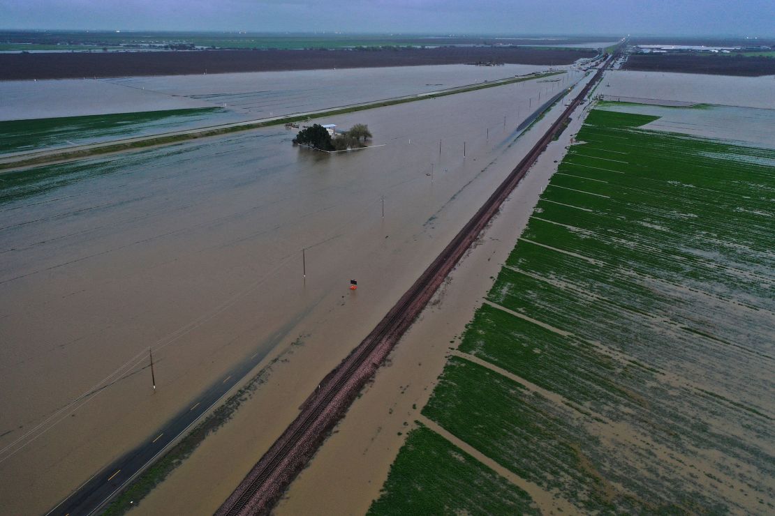
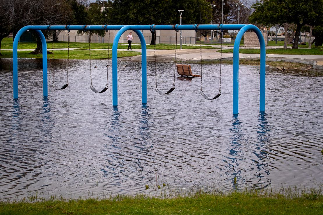
Many areas across southern California had already received more than 2 inches of rainfall by Tuesday afternoon, with more showers still to come Wednesday. “This will foster concerns for rapid runoff, flooding and mudslides given the already wet, saturated soil conditions,” the National Weather Service said.
The worry was that heavy rain and snow could worsen conditions for communities still flooded from the previous atmospheric river that pummeled the state – and ended just days ago.
California has already seen at least 12 atmospheric rivers this winter season that ravaged communities, displaced residents and prompted emergency declarations as floodwater inundated neighborhoods, swelled rivers, damaged roads and sent mud and rocks sliding down hills.
More rain than normal in California
It’s unclear how the climate crisis could be influencing the number of storms that hit the West Coast, but scientists have linked it to an increase in the amount of moisture the atmosphere holds. That means storms, like these atmospheric rivers, are able to bring more moisture inland, leading to an increase in rainfall rates and flash flooding.
Since October 1, Los Angeles has received more than 24 inches of rain — roughly twice as much as it normally gets for this time period. That’s also about 10 inches above its annual average, as the vast majority of California’s rainfall occurs from late fall to early spring.
And it’s not just Los Angeles: cities across the state are seeing very similar numbers.
San Francisco, Oakland, Sacramento, Stockton and Fresno have all seen 150 to 200% of their normal rainfall since October 1.
While the extreme rainfall has triggered flash flooding, mudslides and caused damage, it has also significantly increased critical state reservoirs including Lakes Shasta and Oroville, which have risen by more than 100 and 180 feet respectively since December.
What to expect this week
The widespread rain, mountain snow and strong winds across parts of central and Southern California will continue Wednesday and will gradually clear up Thursday, said National Weather Service Meteorologist Sarah Rogowski.
The heaviest impact will likely be felt in southern California, which could see around 1 to 3 inches of rain across lower elevations and 2 to 4 inches across the foothills through Thursday.
The Weather Prediction Center raised the flood threat to a moderate level Monday for areas of Southern California, covering more than 15 million people in coastal areas from Los Angeles to San Diego.
Soils are still overly saturated with water from last week’s storms, setting the stage for more flooding and rapid runoffs.
The powerful storm could also lash Southern California with maximum wind gusts near 75 mph, adding the dangers of fallen trees and powerlines to the mix of hazards Californians are facing this week.
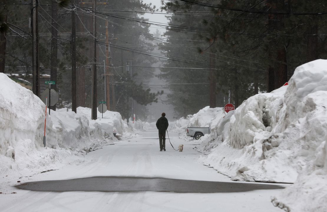
In the Sierra Nevada and Southern California mountains, as much as 3 to 4 feet of snow could be piled on top of already buried communities, likely straining infrastructure and making travel difficult, the weather service said.
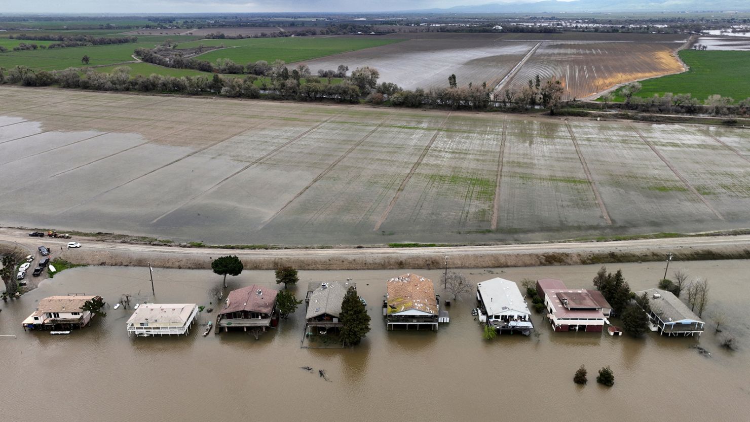
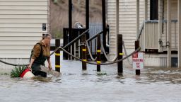
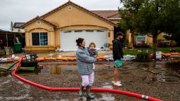
Thousands were evacuated from two small central California towns, Alpaugh and Allensworth, in Tulare County, where there have been multiple breaches in waterways and repair efforts were “unsuccessful with the amount of water,” Tulare County Sheriff Mike Boudreaux said.
Officials worried roads could become impassable and isolate residents, and deputies went door-to-door before dawn Monday asking people to flee.
So far, seven structures were destroyed and more than 680 were damaged by floods in Tulare County, according to Cal Fire.
Crews prepare for mudslides and mountain snow
With more rain on the way, protecting people near vulnerable wildfire burn scar areas is among the top concerns for crews.
Scorched soil can’t absorb rain at a normal rate, making it unstable, explained Yucaipa Fire Chief Grant Malinowski, who is part of the operations group keeping watch over the El Dorado burn scar.
The fear is that mud and debris could slide down, make roads impassable, damage homes and strand people, Malinowski told CNN.
Firefighters across the state have been stationed around burn scars each time an atmospheric river menacingly takes aim at the state – and they’ve been doing it a lot this winter season.

“It’s kind of like almost like fire season right now,” Malinowski said, describing thousands of firefighters and crew members from Cal Fire and the National Guard throughout the state responding to recent storms.
But unlike with wildfires, residents could have less time to get away from mudslides.
“It’s not like a fire where they can see the fire building and getting closer. This is instantaneous. It just happens and it’s too late for you to react to it,” Malinowski said.
And performing rescues in mudslides is no easy task – so it’s important for residents to obey evacuation orders, which aren’t made lightly, Malinowski said.
“We understand the gravity of asking people to voluntarily leave their homes, but it’s also weighed with the ability for us to rescue people, knowing that it’s going to be a very difficult – if not impossible – task to get through just tons of tons of dirt and debris where we just literally can’t make access,” Malinowski said.
Up in the mountains, the concern is heavy snow stranding people.
“The storm is expected to peak on Tuesday and Wednesday and dump as much as three feet of additional snow on mountain communities that were hit with as much of 10 feet of snow during storms in late February and early this month,” San Bernardino County officials said.
The county said it is activating public works employees for 24-hour snow plowing and storm patrol, having County Flood Control District crews active on split shifts during the storm and adding additional sheriff deputies to routine patrols for the next two weeks.
CNN’s Taylor Ward, Joe Sutton, Taylor Romine, Monica Garrett, Brandon Miller and Rachel Ramirez contributed to this report.

