Tar balls from Gulf disaster reach Lake Pontchartrain, shores of Texas


- NEW: Tar balls found in Lake Pontchartrain and off Galveston, Texas
- NEW: Texas finds could have come from passing ship, Coast Guard says
- Weekend tests of massive skimmer inconclusive, owner says
- Storm system off Louisiana could become tropical storm before landfall
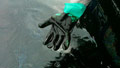
New Orleans, Louisiana (CNN) -- Tar balls linked to the worst oil spill in U.S. history have reached into Louisiana's Lake Pontchartrain and hit the beaches near Galveston, Texas, authorities in those states reported on day 77 of the disaster.
Easterly winds and high waves that hindered skimmers drove blobs of weathered oil up into the eastern end of the lake, which sits north of New Orleans, said Anne Rheams, executive director of the Lake Pontchartrain Basin Foundation. She estimated the amount of oil that has reached the lake at less than 100 barrels, with no hydrocarbon smell.
"They are about the size of a silver dollar, maybe a little bigger, kind of dispersed in long intervals. It's not as dense as it could be, so we're thankful for that," she said.
The Coast Guard reported over the weekend that a shift in weather patterns could send more oil toward sensitive shores in Mississippi and Louisiana, and bad weather over the past few days has significantly hampered cleanup efforts. Rheams said that pattern was expected to persist for at least three more days.
Rear Adm. Paul Zukunft said Friday that the prospect of oil reaching up into Lake Pontchartrain "is where I'm losing the most sleep right now."
"I'm going to look, and if I see even sheen, I'm going to push to make sure that we're moving every and all available resources to respond to this particular area," he said.
 Video: Tricking birds to avoid Gulf
 Video: Rough seas delay oil cleanup
 Video: Is the water safe?
 Video: Tourism in Gulf Shores, Alabama
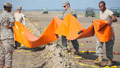
Tar balls had previously been spotted in Rigolets Pass, which connects the lake with Mississippi Sound. Officials in Orleans and St. Tammany parishes have been using heavy booms, barges and skimmers to defend Pontchartrain since the early days of the disaster, but Rheams said high waves and strong easterly and southeasterly winds have complicated the effort.
"The main thing is that they are an indicator that it could be coming more so this way," she said.
State officials closed a swath of the southern part of the 630-square-mile lake to fishing following the discovery, but there was no sign of an impact on wildlife as of Monday, Rheams said.
And in Texas, about 400 miles west of the ruptured offshore well at the heart of the spill, Coast Guard Capt. Marcus Woodring said the total volume of tar balls found over the weekend amounted to about five gallons. And while authorities weren't sure how they made it that far, tests confirmed that at least the first batch collected came from the Deepwater Horizon spill off Louisiana, he said.
None were found Monday, and the area's beaches and waterways remained open, Woodring said. The tar balls were less weathered than researchers would expect, leading to suspicions that the oil was either stuck to the side of a ship's hull or mixed in with ballast water from a passing vessel, Woodring said.
Tar balls are fairly common along the Texas coast, in part because of seepage from undersea oil deposits or from sunken vessels, he said.
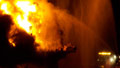
A federal task force has estimated that between 35,000 and 60,000 barrels (about 1.5 million to 2.5 million gallons) of oil have been gushing into the Gulf daily since April 22, when the Deepwater Horizon oil rig sank in the Gulf, two days after it exploded in flames. The accident left 11 workers dead and uncorked an undersea gusher that well owner BP has been unable to cap for 11 weeks.
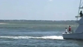
Meanwhile, weekend tests of the A Whale, a converted cargo ship its owners say is the world's largest oil-skimming vessel, turned out to be inconclusive, its owners reported.
Bob Grantham of TMT Shipping Offshore said rough seas over the initial 48-hour testing period made it difficult to determine the skimming results, but he expects more typical sea conditions over coming days will allow more testing. TMT will work with the Coast Guard during the extended testing period "to make operational and technological adjustments aimed at improving skimming effectiveness, given the actual conditions we are encountering in the Gulf," Grantham said.
The A Whale spent the weekend attempting to separate crude oil from seawater in a 25-square-mile area north of the ruptured BP oil well that's caused the largest oil spill in U.S. history. Taiwan-based TMT says the ship can skim about 21 million gallons of oil a day, about 250 times the capability of the modified fishing vessels now being used in the Gulf.
More help is on the way in the form of heavy oil recovery devices, or HORDs. The Deepwater Horizon Incident Joint Information Center says that just weeks after the first HORD was successfully tested in the Gulf off the Alabama coast, the devices are making the cleanup much more efficient and effective, especially in collecting the thick, heavy oil that hampers traditional skimming methods. They are also able to clean up the extremely light and difficult-to-remove sheen left on the water's surface after skimming.
Eight to 10 HORDs, originally dubbed tarball retrieval devices, are being manufactured each day in shipyards in Pensacola, Florida, and Bayou La Batre, Alabama. Up to 1,000 units are expected to be manufactured and put into service, according to the Deepwater Horizon Incident Joint Information Center.
The disaster has scared tourists away from the Gulf Coast and prompted the federal government to close a third of federal Gulf waters to fishing and impose a six-month moratorium on deepwater oil drilling -- a severe blow to states where resorts, fisheries and oil are pillars of the economy. BP said Monday it has spent more than $3 billion on efforts to contain and clean up the spill and pay claims leveled by idled workers.
The National Oceanographic and Atmospheric Administration extended the fishing closures by about 1,100 square miles on Sunday, adding the waters off Louisiana's Vermilion Bay to the off-limits zone. Vermilion Parish President Wayne Touchet said Monday the new closures will hamper local fishermen, but he expects the restrictions to be lifted soon as the weather shifts.
"We weren't really affected by the oil spill until now. At the beginning of the oil spill, we had some closures in state waters, in fishing and oystering areas. Those areas reopened quickly," Touchet said.
"Now, it's the height of shrimping season and (we) have closure in federal waters. Most of our shrimping is in near-shore waters, but they closed at 6 a.m. this morning due to the season to prevent overfishing," he said.
And a tropical disturbance in the Gulf of Mexico, about 50 miles southwest of Morgan City, Louisiana, loomed as a new potential threat Monday evening. The National Hurricane Center reported that there was a 60 percent chance that the disorganized, low-pressure system could develop into a tropical storm before moving inland Monday night or Tuesday.
Since the system is so close to shore, it is not likely to have much time to develop. But it could dump up to 2 to 4 inches of rain on the area as it moves onshore, the hurricane center reported.
BP said it got about 24,955 barrels of oil out of the water Sunday. And the use of burning and dispersants appear to be breaking up the large, uninterrupted tracts of oil that have plagued the Gulf in recent weeks.
Charles Gaiennie, a spokesman for the joint oil spill response, said Monday that aircraft flying over the Gulf are not encountering contiguous patches of oil at the same rate as before. He credits the "proactive response" and, ironically, the rough seas that, while they have somewhat limited the collections operations, have broken up the oil patches.
BP said Monday it is making progress on the long-term solution to the leak -- two relief wells. BP said the first relief well has reached a depth of 17,725 feet and is on its sixth "ranging" run, using an electromagnetic field to determine where best to intersect with the main well for "kill" operations at a target depth of around 18,000 feet. The second relief well is now 13,871 feet deep, BP said.
CNN's Elizabeth Mayo, Dave Hennen, Vivian Kuo and Aaron Cooper contributed to this report.